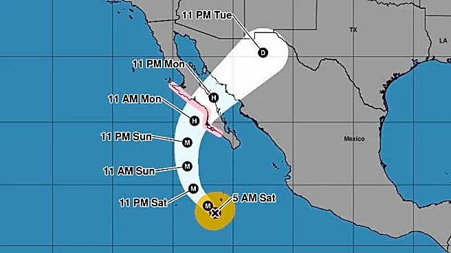









The National Weather Service has issued a flood watch for the El Paso-Las Cruces area and Southern New Mexico as the potential for heavy rains from moisture from Hurricane Polo make their way to the region.
The flood watch is in place from 12 p.m. Monday, Sept. 28, through Tuesday night until 6 a.m. Wednesday, Sept. 30, the NWS El Paso stated.
Repeated rounds of rain showers and isolated thunderstorms are forecast for the region, including the potential for flash flooding especially since the heavy rains last week have saturated the ground, the NWS stated.
The most likely amount of rainfall will be 1.5 inches to 2.5 inches through Tuesday night but some locations could received as much as 3
to 4 inches of rain, the National Weather Service forecast.
The "greatest concern" for flooding in the region will be the north of the Interstate 10 corridor, NWS added.
Hurricane Polo path in Mexico
Precipitation stemming from Hurricane Polo is forecast to head in a northeastern direction toward New Mexico and far West Texas after the hurricane makes landfall along Mexico's Pacific coast.
Hurricane Polo is projected to weaken after making landfall on Monday in the Mexican Pacific coast state of Baja California Sur before crossing the Gulf of California and making a second landfall on mainland Mexico, bringing potentially dangerous flash flooding to parts of Sinaloa, Sonora and Chihuahua, Reuters reported.

The National Hurricane Center said that Polo is expected to drop 4 to 8 inches of rain across parts of Baja California Sur, with maximum amounts of 10 inches, which could cause dangerous flooding and mudslides, Reuters reported.
Daniel Borunda may be reached at dborunda@elpasotimes.com and @BorundaDaniel on X.
This article originally appeared on El Paso Times: Flood watch in El Paso, New Mexico as Hurricane Polo rain heads to area