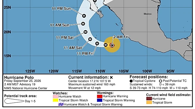

Hurricane Polo is headed toward Mexico, but its biggest impact for Texas will come after the storm moves inland and sends a surge of tropical moisture north into the Southwest.
According to the latest advisory
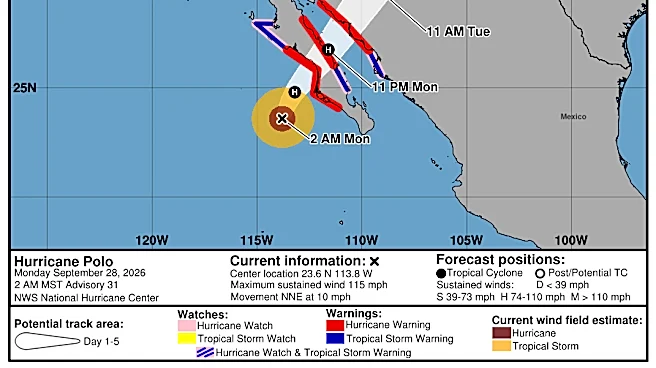
from the National Hurricane Center, Polo is located about 125 miles southwest of Cabo San Lazaro, Mexico, with maximum sustained winds near 115 mph and higher gusts. The Category 3 hurricane is forecast to be near major hurricane strength when it reaches Baja California Sur and weaken slightly before making landfall in mainland Mexico.
In Texas, the moisture from Polo is expected to fuel widespread showers and thunderstorms across West Texas beginning Monday, Sept. 28, with the threat continuing into Wednesday, Sept. 30. Heavy rain and flash flooding will be possible, particularly in areas that have already picked up significant rain in recent weeks, according to the National Weather Service office in El Paso.
Far West Texas is already under a flood watch from Monday afternoon through late Tuesday night, Sept. 28-29. The National Weather Service said tropical moisture will be transported north ahead of Polo, bringing repeated rounds of rain and thunderstorms to southern New Mexico and Far West Texas.
For El Paso, the National Weather Service is forecasting a 90% chance of thunderstorms on Tuesday, Sept. 29, with additional chances of storms on Wednesday, Sept. 30. The forecast calls for temperatures to fall from the upper 80s on Monday to around 80 degrees on Tuesday as tropical moisture moves into the region.
Polo's path through Mexico
Forecasters said Polo is expected to bring life-threatening winds and flash flooding over portions of Baja California Sur and Sonora Monday, Sept. 28, and Tuesday, Sept. 29, with conditions expected to begin deteriorating in Baja California Sur early Monday morning.
The NHC said the Mexican government has issued a hurricane warning for the west coast of Baja California Sur, from Punta Abreojos to Santa Fe, and the east coast of the state from Loreto to Bahía San Juan Bautista. Mainland Mexico also has a hurricane warning in effect from Bahía Kino to Huatabampo.
A hurricane warning means hurricane conditions are expected somewhere within the warning area, in this case within 12 to 30 hours, and that preparations to protect life and property "should be rushed to completion," according to the hurricane center.

Forecasters said hurricane conditions are expected within the warning area along the west coast of Baja California Sur by late Monday afternoon, with tropical storm conditions beginning in the southern portion of the warning area late Monday morning. These conditions are expected to spread northward and eastward throughout the day.
Polo is forecast to produce rainfall totals of 6-12 inches across portions of the state, with 4-6 inches and a maximum of around 8 inches expected across southern and central Sonora. The rain could produce life-threatening flooding and mudslides, forecasters said.
"A storm surge could produce significant coastal flooding in areas of onshore winds," forecasters said in the advisory. "Near the coast, the surge will be accompanied by large and destructive waves."
When will Texas get the heaviest rainfall?
Polo's moisture could turn into a multi-day soaking for parts of Texas, with the heaviest rain shifting east across the state as the storm's remnants merge with a large upper-level system.
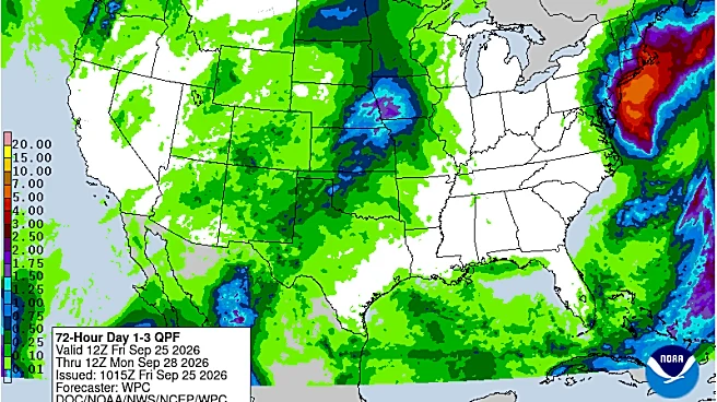
The Weather Prediction Center has placed parts of the Texas Panhandle and Central Texas under a Moderate Risk of excessive rainfall, meaning conditions could support numerous instances of flash flooding. The risk expands across the Southern Plains as the system moves east, with additional heavy rain possible Thursday, Oct. 1.
The heaviest rain is expected to develop as Polo's remnant moisture combines with a surge of Gulf moisture. The WPC said the greatest rainfall on Tuesday, Sept. 29, will be concentrated near the Texas Panhandle, northeastern New Mexico, and southeastern Colorado, before the threat shifts farther into Texas on Wednesday.
By Wednesday, Sept. 30, Central Texas and eastern Oklahoma are under a Moderate Risk for excessive rainfall, while a broader Slight Risk stretches across much of Texas. The WPC said multiple days of overlapping rainfall could increase the risk of flash flooding, particularly where heavy rain falls repeatedly.
North Texas, including the Dallas-Fort Worth area, is expected to get into the action Wednesday. NWS Fort Worth says widespread rain and storms are expected to begin Wednesday and continue through late week, with widespread heavy rainfall increasingly likely and localized flooding possible.
How much rain could Texas get?
- Far West Texas: 1-3 inches of rain could fall in parts of the region, with locally higher amounts possible as tropical moisture from Polo fuels repeated thunderstorms Monday through Wednesday.
- Texas Panhandle: Several inches of rain are possible, particularly near the New Mexico border, where moisture from Polo will interact with a strengthening upper-level system Tuesday and Wednesday.
- North Texas and DFW: About 1-4 inches of rain is possible through the end of the week, with locally higher totals. The heaviest rain is expected Wednesday into Thursday as Polo's moisture spreads east.
- Central Texas: About 1-4 inches is possible, with locally higher totals. The WPC has placed portions of Central Texas under a Moderate Risk for excessive rainfall Wednesday.
- South Texas: Heavy rain becomes possible later in the week as deep tropical moisture spreads across the Southern Plains. Exact totals remain less certain.
- East Texas: Additional rounds of rain could develop Thursday and Friday as the upper-level system slows over the Southern Plains, increasing the potential for localized heavy rainfall.

Remnants of Polo could bring rain to central United States
The remnants of Polo are expected to dump heavy rain across the central United States this week, forecasters said. Around the same time that what is left of Polo enters the United States, a large non-tropical storm will be sweeping eastward from the Great Basin and Rockies, AccuWeather said.
"As the two features combine, perhaps into a massive hybrid storm system, areas of beneficial rain and flash flooding are likely to unfold," AccuWeather meteorologist Alyssa Glenny said.
Hurricane Polo path tracker
This forecast track shows the most likely path of the center of the storm. It does not illustrate the full width of the storm or its impacts, and the center of the storm is likely to travel outside the cone up to 33% of the time.
Hurricane Polo spaghetti models
Illustrations include an array of forecast tools and models, and not all are created equal. The hurricane center uses only the top four or five highest-performing models to help make its forecasts.
Gabe Hauari is a national trending news reporter at USA TODAY. You can follow him on X @GabeHauari or email him at Gdhauari@usatoday.com.
Brandi D. Addison covers weather across the nation as the Weather Connect reporter for the USA TODAY Network and contributes to Texas Connect coverage across the state. She can be reached at baddison@usatodayco.com. Follow her on Facebook here.
This article originally appeared on El Paso Times: Hurricane Polo's moisture heads for Texas. Here's where rain will hit