






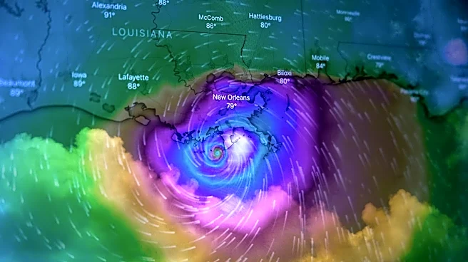
Tropical Storm Fay formed in the Atlantic Ocean Sept. 20, according to a National Hurricane Center forecast advisory, but there are no coastal watches or warnings, or threats to land.
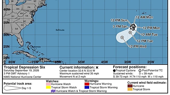
Fay's 45 mph winds were about 450 miles southwest of the Azores, with the storm moving north-northeast at about 5 mph.
Tropical Storm Fay, the sixth named storm of the 2026 Atlantic hurricane season, is hundreds of miles away in the eastern Atlantic and poses no threat to the Tampa Bay region.
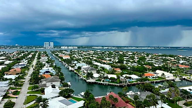
Across Hillsborough, Pinellas, Pasco and surrounding counties, the greater concern today will be afternoon thunderstorms developing in hot and humid conditions. The National Weather Service says a few storms could become strong, producing damaging wind gusts, hail, frequent
lightning and localized flooding from slow-moving downpours.
Shop Amazon for hurricane supplies
➤ Track all active storms
Meanwhile, the NHC is watching two tropical waves in the Atlantic and Caribbean.
The next name after Fay for the 2026 Atlantic hurricane season will be Gonzalo.
➤ Weather alerts via text: Sign up to get updates about current storms and weather events by location
Here's the latest advisory from the National Hurricane Center as of 5 a.m. Sept. 20.
Tampa Bay area weather forecast
For Tampa, St. Petersburg, Clearwater and surrounding west-central Florida communities, scattered to numerous afternoon thunderstorms are expected to develop today.
The National Weather Service says an upper-level low over the eastern Gulf is increasing atmospheric instability and could allow a few storms to become strong. Damaging wind gusts, small hail, dangerous lightning and localized flooding from slow-moving storms are the primary concerns. Humidity remains high, with rainfall totals increasing rapidly under stronger cells. Temperatures will reach around 90 degrees before storms become widespread during the afternoon and early evening.
Where is Tropical Storm Fay?
At 5 a.m. ET, the center of Tropical Storm Fay was located near latitude 33N, longitude 33W. Fay is moving north-northwest near 5 mph.
Forecasters say Fay's general motion is expected for about another day. A turn to the southwest is expected Monday.
Location: About 450 miles southwest of the Azores
Maximum sustained winds: 45 mph
Minimum central pressure: 1004 MB
Spaghetti models for Tropical Storm Fay
➤ Track Tropical Storm Fay
Special note about spaghetti models: Spaghetti model illustrations include an array of forecast tools and models, and not all are created equal. The Hurricane Center uses only the top four or five highest-performing models to help make its forecasts.
Will we get Hurricane Fay?
The National Hurricane Center forecast discussion says the combination of relatively moist air and the merging of warmer and cooler conditions should cause Fay to gain some more strength during the next 12 to 24 hours.
However, an increase in shear and dry air should end its opportunity for strengthening. Fay will likely become a remnant low Tuesday and dissipate by the end of the week.
Could we see a tropical storm or hurricane near Florida in September?
Anything is possible, but chances are low, according to the National Hurricane Center.
Will there be no hurricanes in 2026?
If this year's Atlantic season has no hurricanes by Nov. 30, it will be only the third time it has happened, and you have to go back more than 100 years for the last times, in 1907 and 1914.
Of course, it is possible there were hurricanes, but records before the satellite era depended on observations from those nearby.
Since the satellite era began in 1966, there have been two occasions where we've seen two hurricanes in a season, in 1982 and 2013.
"We have never gone this late into the Atlantic hurricane season without a hurricane in the satellite era," said AccuWeather Lead Hurricane Expert Alex DaSilva.
National Hurricane Center tracking Tropical Storm Fay, 2 tropical waves
Along with Tropical Storm Fay, the NHC is tracking two tropical waves:
- A central Atlantic tropical wave has its axis along 45W from 06N to 21N, slowly drifting westward.
- A western Caribbean tropical wave has its axis along 84W south of 20N, from near the coast of Nicaragua to northeast Costa Rica, moving westward around 7-12 mph.
What is a tropical wave?
"Tropical waves are clusters of showers and thunderstorms that act as the seedlings for many tropical storms throughout the Atlantic season," said Alex DaSilva, AccuWeather lead hurricane expert, via email.
"There are about 60 tropical waves that move across the Atlantic each year, and roughly 10% to 15% of them develop into a tropical system. That's about one in seven.
"Tropical waves are important because they contribute to about 80% of all major hurricanes."
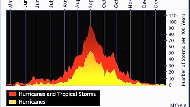
When is hurricane season?
The Atlantic hurricane season runs from June 1 through Nov. 30.
Ninety-seven percent of tropical cyclone activity occurs during this time period, NOAA said.
➤ Hurricane Center testing new cone: What's changing this season?
The Atlantic basin includes the northern Atlantic Ocean, Caribbean Sea and Gulf of America, as the Gulf of Mexico is now known in the U.S. per an order from President Trump. NOAA and the National Hurricane Center are now using Gulf of America on maps and in advisories.
Countdown clock to end of 2026 Atlantic hurricane season
How many tropical storms, hurricanes are in a typical season?
The 30-year average, from 1991 to 2020, is 14 named storms, seven hurricanes and three major hurricanes.
Tampa Bay weather radar for Sept. 20, 2026

Weather watches and warnings issued in the Tampa Bay area
When is the peak of hurricane season?

The peak of the season was Sept. 10, with the most activity happening between mid-August and mid-October, according to the Hurricane Center.
What are names for 2026 Atlantic hurricane season?
Here are the names for the 2026 Atlantic hurricane season and how to pronounce them:
- Arthur: Tropical Storm Arthur formed June 17, 2026
- Bertha: Tropical Storm Bertha formed July 20, 2026
- Cristobal: Tropical Storm Cristobal formed Aug. 12
- Dolly: Tropical Storm Dolly formed Aug. 27
- Edouard: Tropical Storm Edouard formed Sept. 1
- Fay: Tropical Storm Fay formed Sept. 20
- Gonzalo, gohn-SAH-loh
- Hanna, HAN-uh
- Isaias, ees-ah-EE-ahs
- Josephine, JOH-seh-feen
- Kyle, KY-ull
- Leah, LEE-ah
- Marco, MAR-koe
- Nana, NA-na
- Omar, OH-mar
- Paulette, pawl-LET
- Rene, re-NAY
- Sally, SAL-ee
- Teddy, TEHD-ee
- Vicky, VIH-kee
- Wilfred, WILL-fred
Interactive map: See how many hurricanes, tropical storms have passed near your home
Stay informed. Get weather alerts via text
What's next?
We will continue to update our tropical weather coverage to bring you the most current information you need to protect your home and family.
John Gallas and Cheryl McCloud are journalists for the USA TODAY Network-Florida's service journalism Connect team. You can get all of Florida's best content directly in your inbox each weekday by signing up for the free newsletter, Florida TODAY, at naplesnews.com/newsletters.
This story was produced by reporter John Gallas, jgallas@usatodayco.com, with the assistance of Artificial Intelligence (AI). Journalists were involved in every step of the review, editing and publishing process. Learn more at cm.usatoday.com/ethical-conduct.
This article originally appeared on Sarasota Herald-Tribune: Tropical Storm Fay forms in the Atlantic. Tampa-area forecast
Our editors independently choose our recommendations. Some content is produced with paid support from a third party, however our editorial decisions remain independent. If you buy through our links, the USA TODAY Network may earn a commission. Prices and availability may change.