





The Pacific Ocean is heating up, El Niño is strengtheningand a marine heat wave is lingering off the California coast— but another ocean pattern in the Atlantic could add complexity to the climate signals scientists are watching.
Scientists are monitoring a combination of El Niño, Atlantic La Niña and unusually warm ocean temperatures that could influence how weather patterns evolve across California in the months ahead.
El Niño will likely remain the dominant ocean pattern shaping California’s winter weather, influencing the position of the jet stream and the potential for storms to reach the West Coast. But other parts of the climate system — including Atlantic sea surface temperatures and a persistent marine heat wave — could subtly influence
atmospheric patterns and add uncertainty to the forecast.
El Niño strengthens across the Pacific
El Niño conditions are intensifying across the tropical Pacific, with ocean temperatures climbing steadily.
The latest observations show sea surface temperatures running more than 2 degrees Celsius above average, a sign the event is strengthening toward a potentially very strong El Niño.
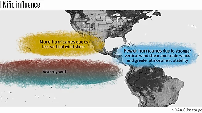
Historically, El Niño can shift the jet stream southward, increasing the potential for wetter conditions across parts of the southern United States and California during winter. However, the exact impacts depend on the strength, location and timing of the event — along with other atmospheric patterns.

A marine heat wave is simmering off California’s coast
Adding another layer of complexity: ocean temperatures remain unusually warm along the California and Baja California coasts.
Forecasts show a 70% to 100% chance of marine heat wave conditions continuing off California through the end of the year, according to the latest global marine heat wave outlook.
Marine heat waves can influence coastal temperatures, marine ecosystems and the atmosphere above the ocean. A warmer ocean can provide additional heat and moisture to storms, although the impacts on rainfall patterns are not always straightforward.
The Atlantic is sending its own signal
Across the Atlantic, scientists are also monitoring aLa Niña-like patternthat could influence global atmospheric circulation.
The Atlantic pattern does not directly control California’s weather the way El Niño does, but it can interact with Pacific conditions and affect how weather patterns evolve across North America.
That means forecasters are watching not just one ocean, but how multiple ocean basins interact.
What it could mean for California
The combination of a strengthening El Niño and persistent marine heat could create a complicated winter setup for California.
Forecasters will continue watching:
- Storm track changes: El Niño can shift the Pacific jet stream and influence where storms make landfall.
- Rain and snow potential: California’s precipitation outlook will depend on how El Niño interacts with other climate patterns.
- Coastal temperatures: Warm ocean waters could keep coastal areas warmer than average.
- Extreme weather risks: Ocean temperatures can influence atmospheric moisture available to storms.
The oceans are not working independently — they are part of a connected climate system. This winter’s weather may depend on how those competing signals line up.
Stay informed. Get weather alerts via text
Brandi D. Addison covers weather across the nation as the Weather Connect reporter for the USA TODAY Network and contributes to Texas Connect coverage across the state. She can be reached at baddison@usatodayco.com. Follow her on Facebook here.
This article originally appeared on Palm Springs Desert Sun: A triple ocean tug-of-war could shape California weather