




A continuous shared path for cyclists and pedestrians, public art, pocket parks, improved lighting and crossings and a link to the longest state-designated trail in the U.S., the Iron Belle Trail, are all future possibilities for an east-west road running through four southern Macomb County cities.
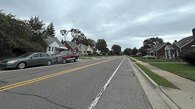
The proposed Stephens Road Greenway would be along an approximately 6-mile stretch of Stephens Road from Lawrence Avenue (just west of Van Dyke) in Center Line on the west, through Warren and Eastpointe, to Little Mack Avenue in St. Clair Shoreson the east.
Stephens Road is between 9 Mile and 10 Mile roads and is dotted by houses, businesses, industries, houses of worship, parks, schools, the Michigan Military Technical & Historical Society in Eastpointe
and the St. Clair Shores Civic Arena. It has existing sidewalks and on-street parking in some stretches and crosses large, busy thoroughfares, such as Van Dyke, Gratiot and I-94, in others.
The proposed greenway could help people connect to public transportation, some of the cities' downtowns, the Nautical Mile inSt. Clair Shores, Lake St. Clair and the Iron Belle Trail, which would be on the Center Line end of the corridor.
"That gives Stephens a role in a much larger regional network while still serving very practical local purposes. Getting someone safely to a park, connecting a neighborhood to a business or simply giving people a better way to get around our community," Hunter Manikas, economic development technician for the city of Warren, told Warren City Council at its Sept. 15 meeting.
He said Stephens Road is "one of our most interesting corridors" with "a great deal of potential lying beneath this modest roadway."
Chris Causley of St. Clair Shores, who is president of the Michigan Military Technical & Historical Society, said he attended a meeting about the greenway proposal in St. Clair Shores.
"I think anything that would make the corridor more accessible would be wonderful," he said, adding that he would be in favor of making "everything look a little nicer."
Causley said he's not sure how many people would ride through the corridor, but if people were to use it, it would be "wonderful" if they stopped at the museum.
Safety improvements rank high in study
Warren, Eastpointe and Center Line city councils discussed, accepted or adopted a feasibility study about the proposed greenway during meetings in September. St. Clair Shores City Council could do so at its Sept. 21 meeting.
The cities did not make any future financial commitments, acquire any properties or make any changes to existing infrastructure when approving the54-page study, which could serve as a planning document going forward.
The study was possible in part with a nearly $33,000 planning grant from the Southeast Michigan Council of Governments, with remaining costs of the $46,500 project shared by the cities, according to materials in agenda packets for Eastpointe and St. Clair Shores city councils.
Work on the study began in the fall of 2025 and included meetings with stakeholders, from city officials to residents to utility and transportation representatives, and a visit to the corridor. An online community survey earlier this year drew 642 responses from a wide range of ages, mobility preferences and corridor users, 66% of whom indicated they were supportive of creating the greenway.
Of the survey's respondents, 35% were from Eastpointe, 29% from Warren, 27% from St. Clair Shores, 5% from Center Line and 4% from other locations.
The most frequently cited concerns with the current corridor were vehicle speeds; lack of dedicated pedestrian and cycling facilities; poor lighting and visibility; difficult crossings and intersections; and traffic volumes, according to the study by Anderson, Eckstein & Westrick, Inc., which provides engineering services to the four cities.

The study said safety-related improvements ranked among the highest priorities, particularly those focused on crossings, pedestrian visibility and dedicated space for walking and cycling. There was also strong interest in beautification, landscaping and amenities that would create a more welcoming and recognizable corridor.
The study found that the corridor currently has inconsistent pedestrian and cyclist accommodations; gaps in connectivity; limited streetscape improvements; and challenges related to crossing safety at major intersections. Constraints include on-street parking considerations, right-of-way limitations and existing utilities and infrastructure to work through.
For example, sidewalks are present along much of the corridor, but widths, conditions and separations from traffic vary, and existing cycling accommodations are limited and inconsistent with cyclists sharing lanes with vehicle traffic or using sidewalks, according to the study.
Iron Belle Trail tie-in, greenspaces by curbs possible
Eastpointe's Economic Development Manager Ian McCain called the greenway proposal effort "a labor of love for a number of months" when speaking to Eastpointe City Council on Sept. 1. The city of Warren applied for the grant, he said, and Eastpointe has the longest stretch of road along the corridor.
McCain told the council that the greenway would improve connectivity; expand recreation; enhance safety; promote environmental sustainability; strengthen community identity; and tie into other master plans in the cities and neighboring communities.
Some of the ideas proposed to link the corridor include a shared-use path that would connect to the Iron Belle Trail in Center Line.
The Iron Belle Trail is more than 70% complete, according to the state, connecting more than half of Michigan's counties and spanning more than 2,000 miles from the western Upper Peninsula to Belle Isle in Detroit. It features a biking route along the eastern side of the state using existing bike paths, lanes and designated routes, and a hiking route on the western side of the Lower Peninsula.
Other ideas for the Stephens Road Greenway, which is identified in eight segments, include landscaping; placemaking and wayfinding features; extending curbs and creating greenspaces by curbs; green stormwater infrastructure; utility adjustments, and turning unused parcels into pocket parks, trailheads or areas for benches or bicycle repair stations.
State and federal grants and other private and public funding opportunities would be sought to help cover the cost of any improvements in the corridor.
Manikas told Warren City Council that some efforts, such as public art, could be less expensive and done more quickly, such as within a year or two; then officials could build up to more expensive improvements as funding becomes available.
He said there is no long-term commitment to construct everything in the shared corridor and expenditures in the city's portion would come to council for consideration. Warren council members were supportive of the effort, pleased the city was collaborating with its neighbors and hoping the greenway could be a driver of economic development.
McCain told Eastpointe City Council the proposed greenway would turn Stephens Road into a "safer, greener, and more connected corridor."
Contact Christina Hall: chall@freepress.com. Follow her on X, formerly Twitter: @challreporter.
Support local journalism. Subscribe to the Free Press.
Submit a letter to the editor at freep.com/letters.
This article originally appeared on Detroit Free Press: This road in 4 Michigan cities could get safer, greener, more connected