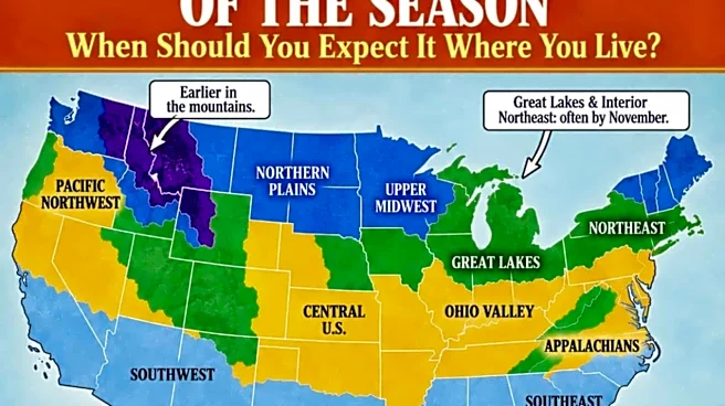





The Farmers' Almanac released a forecast map showing when the typical first snowfall is expected across the United States. The highest elevations in the Pacific Northwest and northern Rockies — including parts of Idaho, Montana, Washington and Wyoming — are expected to be the first areas to see measurable snow this fall, according to the report.
But it's important to note that "an August or September mountain snowfall does not necessarily mean winter has arrived for good," the Farmers' Almanac says. "Early snow often melts quickly when warmer weather returns."
Here's what the Farmers' Almanac predicts and what the National Weather Service shows as the average dates for the first measurable snowfall in some key New York communities.
What's the outlook in New York?
Northern New
York, including much of the Adirondack region, could see its first snow in October, while the remainder of New York is expected to see its first snow of the season in November, according to the Farmers' Almanac.
Lake-effect snow is also common in western and central New York, as residents know. But lake-effect snow does not have a specific start date. The season begins "as increasingly cold air crosses the still-warm Great Lakes during late autumn," Weather Service forecasters said.
According to updated National Weather Service data, the average date for the first measurable snowfall ranges from early November to mid-December, depending on the community. Saranac Lake, which is near the High Peaks and typically sees earlier snowfall than much of New York, has the earliest average first snowfall date at Oct. 23, according to the Weather Service.
NWS: When to expect snow in New York

According to the National Weather Service, the average dates for the first measurable snowfall in key New York communities include:
- Saranac Lake, New York — Oct. 23
- Binghamton, New York — Nov. 1
- Syracuse, New York — Nov. 5
- Buffalo, New York — Nov. 8
- Rochester, New York — Nov. 8
- Albany, New York — Nov. 16
- Poughkeepsie, New York — Nov. 30
- Central Park in New York City — Dec. 7
- Islip, New York — Dec. 14
MORE: How much snow will New York get this winter?
How accurate is the Farmers' Almanac at predicting the first snowfall?
Weather watchers can track the accuracy of the Farmers' Almanac, which notes that its first snowfall map is a "climatological guide rather than a forecast for one particular storm."
See when the Farmers' Almanac expects snow in New York

According to the Farmers' Almanac's 2026-27 winter forecast, the Northeast could see a "tricky mix of rain, sleet, ice and heavy wet snow."
The Almanac predicts a winter of "snow, sleet, and surprises," with some areas experiencing repeated storms and quick cold snaps.
Here's the Farmers' Almanac's forecast for the typical first snowfall in New York state.
Snow in November
In addition to the Plains and central Rockies, "the Great Lakes and interior Northeast often see their first measurable snow in November," according to the Farmers' Almanac.
Regarding the overall prediction for this winter, inland areas of the Northeast could see several rounds of heavy, wet snow, particularly in January and February, according to the Almanac. Small changes in storm tracks and temperatures could determine whether New Yorkers see rain, sleet, freezing rain or accumulating snow.
The Almanac advises residents to be prepared for forecasts to change quickly as storms approach.
Contributing: USA TODAY Network
This article originally appeared on Rochester Democrat and Chronicle: When will New York see its first snow? See snowfall dates