
Triple-digit temperaturescontinue to grip parts of Tennessee, but with summer winding down and fall just around the corner, many Tennesseans are already looking ahead to the colder months.
As winter draws
closer, the two questions on everyone's minds are: When will the first snowflakes fall, and could Nashville wake up to a white Christmas?
While no one can predict exactly what the coming winter will bring, historical climate data and long-range outlooks offer some clues about when Tennessee typically sees its first snowfall and which parts of the state are most likely to see accumulating snow before the holiday season.
Here's what the Farmer's Almanac tells us about what to expect in Tennessee this winter season.
When will TN receive snow? What to know about Farmer's Almanac prediction

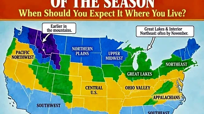
According to the Farmers' Almanac snowfall map, West and Middle Tennessee could see its first snowfall sometime between late November and December, while East Tennessee could see snowflakes as soon as early November, though the exact timing varies.
The almanac noted that latitude alone does not determine when the first snow arrives. Factors such as elevation, storm tracks and local weather patterns can impact the date.
"This is a climatological guide rather than a forecast for one particular storm," the almanac wrote. "Elevation, latitude, nearby bodies of water and the weather pattern in a particular year can move the first snow considerably earlier or later."
The almanac also highlighted that the definition of a "first snow" can differ.
In some cases, it may refer to the first snowflakes observed falling, even if they melt immediately without accumulating. Others consider it the first measurable snowfall, defined as at least 0.1 inch of accumulation, the threshold commonly used by the National Weather Service.
A first significant snowfall is generally considered an event that leaves at least an inch of snow on the ground.
Will Nashville see a white Christmas in 2026?
A white Christmas remains a relatively rare event in Nashville, according to the weather service.
Historical records show Nashville has a 19% chance of seeing at least a trace of snow on Christmas Day and an 8% chance of recording measurable snowfall of 0.1 inch or more.
The city's most recent white Christmas occurred in 2010, when 1.1 inches of snow fell.
The snowiest Christmas on record came in 1969, when nearly 3 inches of snow blanketed the city. According to the weather service, a mix of rain and snow began around midnight before changing to all snow through much of Christmas morning.
Since recordkeeping began in 1884, Nashville has had 28 Christmases with at least a trace of snow or more.
When does Middle Tennessee receive its first snowfall?
According toclimate records from the National Weather Service office in Nashville, Middle Tennessee typically sees its first measurable snowfall between mid- and late December.
On average, Crossville records its first measurable snowfall around Dec. 15, Nashville around Dec. 23 and Clarksville around Dec. 27.
Tennessee winter weather averages
Winter weather patterns vary across Tennessee, with Memphis typically receiving the most precipitation during December, January and February, according tolocal climatology data from the weather service.
Nashville averages 4.43 inches of precipitation and a mean temperature of 42.7 degrees in December, 4.02 inches and 39.6 degrees in January, and 4.47 inches and 43.4 degrees in February.In Memphis, precipitation averages 5.49 inches in December, 4.14 inches in January and 4.55 inches in February, while mean temperatures range from 44.8 degrees in December to 42.1 degrees in January and 46.1 degrees in February.
In Knoxville, precipitation averages 3.76 inches in December, 3.65 inches in January and 3.81 inches in February, alongside mean temperatures of 39.3, 36.4 and 40 degrees respectively.
Across all three cities, January is typically the coldest month of the winter season.
Middle Tennessee highest winter snowfalls
Middle Tennessee has seen significant snowfall during past winter seasons. In Nashville, the snowiest winter on record occurred during the 1959-60 season, when nearly 40 inches of snow fell across the city.
During that same season, Clarksville recorded about 33 inches of snow, while Crossville received roughly 60 inches, the highest total among the three cities.
Middle Tennessee top 5 snowstorms
Here's a look at Middle Tennessee's top five snowstorms.
Nashville
- March 1892: 17 inches
- February 1886: 16 inches
- February 1929: 15 inches
- December 1963-January 1964: 10 inches
- January-February 1951: 10 inches
Clarksville
- March 1940: 16 inches
- January 1909: 13 inches
- January 1910: 12 inches
- March 1986: 10 inches
- February 1969: 10 inches
Crossville
- March 1993: 20 inches
- February 1960: 13 inches
- December 1963: 13 inches
- February 1996: 12 inches
- February 1967: 11 inches
When is the first day of winter? What to know about the winter solstice
The first day of winter in the Northern Hemisphere arrives with the winter solstice, which will occur on Dec. 21, 2026, at 2:50 p.m. CT. The annual event marks the astronomical start of winter and occurs each year between Dec. 20 and Dec. 23, according to the almanac.
The winter solstice also marks the shortest day and longest night of the year in the Northern Hemisphere, as it brings the fewest hours of daylight.
After the solstice, daylight hours gradually begin to increase, continuing to grow longer until the summer solstice, which marks the first day of summer and the longest day of the year.
Diana Leyva covers trending news and service journalism for The Tennessean. Contact her at Dleyva@gannett.com.
This article originally appeared on Nashville Tennessean: When will Tennessee get its first snow? What the Farmers' Almanac says
Our editors independently choose our recommendations. Some content is produced with paid support from a third party, however our editorial decisions remain independent. If you buy through our links, the USA TODAY Network may earn a commission. Prices and availability may change.