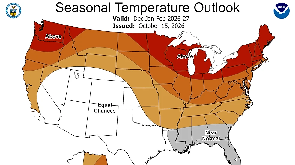






Ohio could see a warmer-than-usual winter with less snow than normal as a strong El Niño influences weather patterns across the Great Lakes region, according to the National Oceanic and Atmospheric Administration's latest winter outlook.
The outlook released Thursday, Oct. 15, favors above-average temperatures across the Midwest, including Michigan, and drier-than-average conditions in parts of the Great Lakes region. It covers December 2026 through February 2027.
But a milder winter overall doesn't rule out major snowstorms or periods of bitter cold.
“We have to remember that a strong El Niño is not necessarily related to the severity of the impacts,” National Weather Service Director Ken Graham said during a NOAA media briefing. “It doesn't erase
the risk.”
A milder seasonal outlook does not mean a storm-free winter.
What does NOAA's winter forecast say about Ohio?
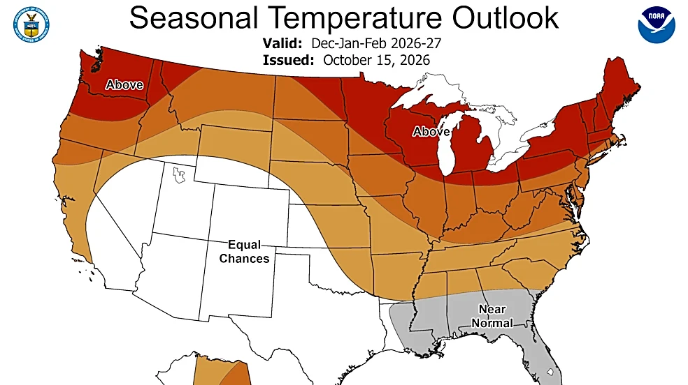
NOAA's outlook favors above-average temperatures across Ohio and much of the Midwest. Its precipitation forecast is less definitive for the Ohio Valley, where the agency does not strongly favor above- or below-average seasonal precipitation.
The outlook describes the likelihood of broad climate patterns over several months. It does not predict individual storms, exact snowfall totals or the timing of cold-air outbreaks.
That distinction is important for Ohio, where winter conditions can vary between the Lake Erie shoreline and communities farther south.
A warmer seasonal average does not mean every week will be mild. Ohio could still experience stretches of freezing weather interrupted by periods of above-average temperatures.


Will Ohio get less snow this winter?
Ohio could see less persistent snow cover if the warmer pattern expected during El Niño develops, but the state's seasonal snowfall totals remain uncertain.
During the NOAA briefing, meteorologist Jon Gottschalck discussed the expected snowpack across the Great Lakes region and the interior Northeast.
"The snow pack is likely to be less than normal," Gottschalck said.
That's because a shift in the storm track farther east and south can limit the conditions that carry moisture from the Great Lakes toward inland areas. Warmer air can also make it harder for snow to accumulate and remain on the ground.
Gottschalck also explained how El Niño can influence lake-effect snow, which is particularly relevant to communities near Lake Erie.
"With warmer temperatures as well, during the El Niño events, there's the potential for less lake effect snow," he said.
However, lake-effect snow depends on individual weather setups, including the direction of the wind and the temperature difference between the lake and the air above it. Those conditions can still develop during a warmer-than-average winter.
Could Ohio still see major snowstorms and extreme cold?
A warmer-than-average winter does not eliminate the possibility of disruptive snowstorms or dangerous cold.
During the briefing, NOAA officials emphasized that seasonal forecasts describe the overall pattern rather than the weather residents will experience during a particular storm.
Major cold outbreaks and snowstorms can still occur even when the seasonal outlook favors warmer conditions.
That means Ohio residents should not interpret the forecast as a guarantee of fewer winter weather disruptions. A single storm can bring heavy snow to parts of the state, while other communities receive little accumulation.
Northern Ohio also faces the possibility of lake-effect snow near Lake Erie, depending on wind direction and atmospheric conditions.
Brandi D. Addison covers weather nationwide as the Weather Connect reporter for the USA TODAY Network and contributes to Texas Connect coverage statewide. She can be reached at baddison@usatodayco.com. Follow her on Facebook here.
This article originally appeared on The Columbus Dispatch: Will Ohio have a mild or brutal winter? Latest NOAA forecast amid El Niño