







After another soggy weekend and several rounds of thunderstorms, central Ohio is finally expected to catch a break from the rain this week.
The National Weather Servicesays scattered showers and thunderstorms remain possible Aug. 17, mainly between 8 a.m. and 5 p.m., with locally heavy rainfall that could lead to flooding. A hazardous weather outlook remains in effect for much of central Ohio because of the flood threat, while portions of eastern Ohio remain under a flood watch.
"A cold front will move across the area today," the NWS in Wilmington said on X. "Another cold front will slowly move through Wednesday night into Thursday. This will result in a week that is not as warm or humid with showers and thunderstorms limited to today and midweek."
Monday's showers are expected to taper off by Monday evening, followed by partly cloudy skies overnight.
Aug. 18 is shaping up to be the driest day of the week, with mostly sunny skies and a high near 81 degrees.
Rain chances return Aug. 19 in the afternoon and evening, when showers and thunderstorms become likely. The National Weather Service gives those periods a 60% chance of precipitation, with another chance of showers lingering into Thursday before drier weather returns for the end of the week.
Aug. 21 through Aug. 23 look mostly dry, with mostly sunny skies and highs hovering around 80 degrees.
How much rain fell in Columbus this weekend?
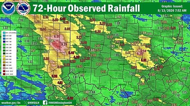
Rainfall totals varied significantly depending on where storms repeatedly tracked over the weekend.
Official observations from NOAA's NOWData recorded 1.26 inches of rain at John Glenn Columbus International Airport over the weekend, including 0.74 inches Aug. 15 and 0.52 inches Aug. 16. The Dayton area picked up 1.47 inches this weekend.
More rain has fallen in eastern Ohio, where Gov. Mike DeWine is sending additional state resources to Perry, Muskingum and Perry counties.
As much as 10 inches of rain has fallen in Crooksvillein the past week, Fire Chief Dyrall Newlon told the Zanesville Times Recorder. Vehicles were submerged in the waters, and homes and businesses flooded. Hundreds of residents were rescued by emergency personnel.
The wet weekend continued an already soggy month. Through Aug. 16, Columbus has picked up 5.37 inches of rain this month - well above the 1.90 inches that's considered normal by this point in August. Southern Ohio near Cincinnati recorded 3.29 inches of total rainfall this month.
Columbus weather forecast
Monday: A 50% chance of showers and thunderstorms, mainly before 5 p.m. Mostly cloudy, with a high near 82 degrees.
Monday night: Partly cloudy, low around 64 degrees.
Tuesday: Mostly sunny, high near 81 degrees.
Wednesday: Showers and thunderstorms likely after 2 p.m., high near 81 degrees. Chance of rain: 60%.
Thursday: A 30% chance of showers. Partly sunny, high near 79 degrees.
Friday: Mostly sunny, high near 79 degrees.
Saturday: Mostly sunny, high near 80 degrees.
Sunday: Mostly sunny, high near 78 degrees.
Trending reporter Amani Bayo can be reached at abayo@dispatch.com.
This article originally appeared on The Columbus Dispatch: When will the rain stop in Columbus? Here's when drier weather returns