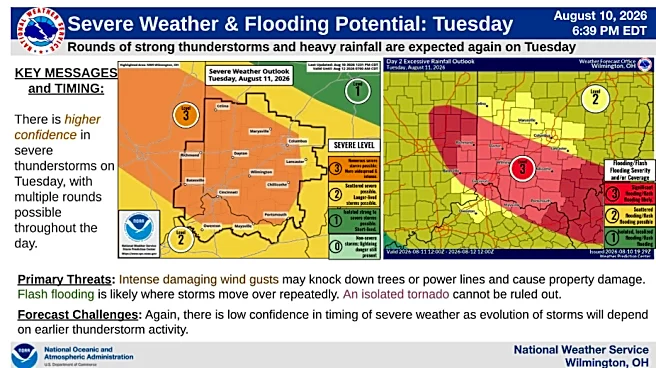








Be prepared for a potentially dangerous rounds of severe weather Tuesday, with forecasters warning that a significant damaging wind event could develop in the afternoon and evening. The entire region is also under a flood watch as heavy rainfall is possible.
The National Weather Service says conditions are coming together for a widespread severe thunderstorm outbreak capable of producing wind gusts exceeding 75 mph on Aug. 11. If storms organize into a large, long-lived complex, widespread tree damage, power outages and structural damage could occur across the region.
The environment is primed for a widespread, potentially significant damaging wind event, forecasters noted, with the most dangerous storms expected during the peak heating hours
of the afternoon and evening.

Although destructive straight-line winds are the primary threat, isolated tornadoes could develop within the squall line, especially on its northern flank. Large hail also remains possible in the strongest storms.
Flash flooding concerns growing
In addition to the severe storm threat, forecasters are raising concerns about flash flooding today through Tuesday night.
Multiple rounds of thunderstorms could dump several inches of rain across portions of the region, particularly where storms repeatedly move over the same locations. Northern areas face the greatest flooding risk during the day.
A flood watch is in effect through Wednesday morning.
Of even greater concern is the potential for heavy rainfall to continue after the severe wind threat passes. Moisture is expected to flow into the region behind the storms, allowing additional thunderstorms to develop and repeatedly track over the same areas.
Forecasters are watching for a "back-building" storm pattern, where new thunderstorms continuously form over rain-soaked locations. If this setup occurs, localized rainfall totals between 5 and 7 inches could develop by Wednesday, leading to significant flash flooding.
Looking ahead
Unsettled weather is expected to continue through the remainder of the week, with additional chances for thunderstorms and heavy rainfall through Friday. Forecasters say drier conditions may finally begin returning late Friday and continue into the weekend.
Residents are urged to stay alert for forecast updates, have multiple ways to receive warnings, and be prepared to take action quickly if severe thunderstorm, tornado or flash flood warnings are issued.
Cincinnati weather forecast
Tuesday: A chance of showers and thunderstorms, mainly after 3 p.m. Partly sunny, with a high near 89. Heat index values as high as 100. Light south wind becoming southwest 5 to 9 mph in the morning. Chance of precipitation is 50%. New rainfall amounts between a half and three quarters of an inch possible.
Tuesday night: Showers and thunderstorms before 2 a.m., then showers likely and possibly a thunderstorm between 2 a.m. and 4 a.m., then a chance of showers and thunderstorms after 4 a.m. Low around 70. Northeast wind around 6 mph becoming calm in the evening. Chance of precipitation is 90%. New rainfall amounts between three quarters and one inch possible.
Wednesday: Showers and thunderstorms likely before 10 a.m., then a slight chance of showers and thunderstorms after 5 p.m. Cloudy, then gradually becoming mostly sunny, with a high near 89. Heat index values as high as 101. Calm wind becoming west 5 to 7 mph in the afternoon. Chance of precipitation is 60%. New precipitation amounts between a half and three quarters of an inch possible.
Wednesday night: A chance of showers and thunderstorms before 8 p.m., then showers likely and possibly a thunderstorm between 8 p.m. and 2 a.m., then showers likely after 2 a.m. Mostly cloudy, with a low around 70. Light and variable wind. Chance of precipitation is 70%. New rainfall amounts between a quarter and half of an inch possible.
Thursday: Showers likely, with thunderstorms also possible after 11 a.m. Mostly cloudy, with a high near 87. Calm wind becoming west around 6 mph in the afternoon. Chance of precipitation is 70%. New rainfall amounts between a half and three quarters of an inch possible.
Thursday night: Showers likely and possibly a thunderstorm. Mostly cloudy, with a low around 70. Chance of precipitation is 70%. New rainfall amounts between a quarter and half of an inch possible.
Friday: A chance of showers, with thunderstorms also possible after 2 p.m. Mostly cloudy, with a high near 85. Chance of precipitation is 40%.
Friday night: A chance of thunderstorms before 8 p.m. Partly cloudy, with a low around 66. Chance of precipitation is 30%.
Saturday: Mostly sunny, with a high near 86.
Source: National Weather Service in Wilmington
This article originally appeared on Cincinnati Enquirer: Storm outbreak brings potential for 75 mph winds, flooding to Cincinnati area