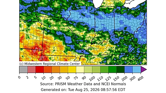







It feels like it's rained a lot this summer in Greater Cincinnati (like a lot), but is this actually the rainiest summer the region has had recently? Not quite.
In August alone, the Queen City saw torrential downpours, a derecho and confirmed tornadoes
, but it wasn't even close to being the rainiest month so far this year. June holds the record for the most rainfall totals so far with 7.57 inches, per the National Weather Service.Here's what to know about Cincinnati's summer rainfall and if it's truly been a rainy season for the record books.
Has this been Cincinnati's rainiest summer so far?
Not exactly, but we did get more August rain than last year.
In August, the Cincinnati/Northern Kentucky International Airport recorded 3.73 inches of rain, according to the National Weather Service. In 2025,
the Cincinnati region only saw 2.52 inches of rain in August.
"Broadly speaking, the rainfall amounts in the immediate Cincinnati area range from 3-8 inches for the month of August," said Nate McGinnis, meteorologist for the National Weather Service office in Wilmington. So, we fall right into the low side of normal.

As for summer (June through September), the region has seen 15.04 inches of rainfall so far since June 1, which is likely to top last year's summer precipitation, which totaled 15.23 inches during the entire three-month period.
So why is this wet pattern happening?
According to McGinnis, "as opposed to the last few years, a ridge of high pressure was positioned farther to the southwest inside of over the Ohio Valley. This high pressure has continued to feed moisture into the Ohio Valley week after week. Additionally, a trough over southeast Canada has provided multiple storm systems that tracked through the Midwest and Ohio Valley."
A derecho contributed to August rainfall totals
The powerful thunderstorm that ripped through Greater Cincinnati on Aug. 11 was classified as a "derecho" by the National Weather Service, a phenomenon that Cincinnati hasn't seen in over a decade.
A derecho is a line of fast-moving thunderstorms with destructive winds, according to the National Environmental Satellite, Data, and Information Service. Its winds are as powerful as those found in hurricanes and tornadoes, except derecho winds move in straight lines.

"Derecho" means "straight" in Spanish. These winds can travel more than 58 miles per hour; some even reach up to 130 miles per hour.
According to the National Weather Service, a derecho is a "somewhat rare type of severe thunderstorm." But when they do happen, they're usually most common in the Midwest. The last time a "derecho" storm hit Greater Cincinnati was in June 2012.
Here's a look at Cincinnati's rain totals so far this year
According to the National Weather Service, the rainiest year in Cincinnati history came in 2011, when the region saw 73.28 inches, with the rainiest month occurring in April with 13.52 inches.
Here's a look at Cincinnati's rain totals so far this year:
- January: 1.38 inches.
- February: 1.15 inches.
- March: 5.82 inches.
- April: 3.99 inches.
- May: 6.35 inches.
- June: 7.57 inches.
- July: 3.74 inches.
- August: 3.73 inches.
The year-to-date rainfall total so far is 33.73 inches.
This article originally appeared on Cincinnati Enquirer: Cincinnati had a stormy summer. Is it one of the rainiest ever?