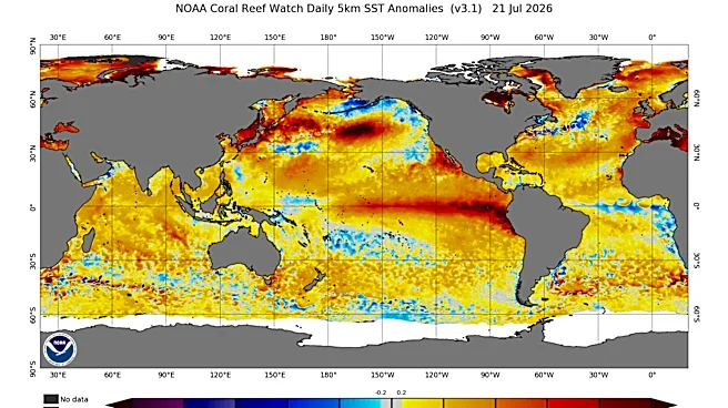

A strengthening Super El Niño could shake up weather patterns across the United States this fall and winter.
Across parts of the country, last winter brought November snowstorms, early blizzard warnings
and repeated blasts of Arctic air. Ohio and many other regions endured frigid temperatures and Winter Storm Fern in early 2026. Now, forecasters are watching whether a rapidly strengthening Super El Niño could influence the 2026-27 winter. Strong El Niño events can shift the jet stream and funnel more storms and moisture into parts of the United States, though it's still too early to know exactly how the developing pattern could affect Ohio or the rest of the country.
So what could all of that mean for Ohio? Here's what forecasters and past El Niño winters suggest Ohio could see this winter.
What makes a Super El Niño different?
Super El Niño is one of the strongest versions of El Niño. It happens when sea-surface temperatures in parts of the equatorial Pacific rise at least 2 degrees Celsius above average, making it one of the strongest forms of El Niño, according to The Weather Channel.
El Niño is a periodic warming of water in the central and eastern equatorial Pacific Ocean that can influence global weather patterns for several months.
What could a Super El Niño mean for Ohio? What history suggests
A Super El Niño can disrupt weather patterns across the country, but Ohio likely won't see meaningful effects from El Niño until winter, when the climate pattern has a stronger influence on North American weather, according to Raelene Campbell of the National Weather Service office in Cleveland.
In Ohio, history points toward a warmer, drier and less snowy winter.
"It's going to be drier and warmer (in Ohio this winter)," Campbell told the Canton Repository. "Overall snowfall may be decreased, but when I say that, that's not accounting for lake effect."
Historical research by National Weather Service in Cleveland and Cincinnati reached a similar conclusion, that moderate to strong El Niño winters across the Ohio Valley and Lower Great Lakes were typically warmer, drier and less snowy than normal.
For Ohioans, the historical odds favor a milder winter rather than a harsh one. That doesn't mean snowstorms won't happen. But if this El Niño develops as expected, history suggests much of the state would see warmer temperatures, less precipitation and less snowfall overall.
Could winterlike weather arrive earlier than usual in Ohio, U.S.?
Typically, El Niño’s strongest influence on the atmosphere emerges during late fall and winter, as warming in the tropical Pacific becomes more established. According to Severe Weather Europe, those ocean temperatures are "building at a remarkable pace, setting the stage for a highly active weather pattern as we head into the upcoming cold season."
"This is important because fall is usually a transition season, with weaker and less organized seasonal patterns," the analysis states. "But the newest forecast trends suggest a more connected evolution, where the Super El Niño influence just keeps amplifying."
Super El Niño could begin influencing weather patterns earlier than usual, with a fall setup that more closely resembles a typical El Niño winter, according to the analysis. Forecast models indicate the potential for a stronger jet stream across the southern United States, which could help steer more storm systems and draw additional moisture into the country.
That matters because winter storms need more than just cold air — they also need moisture and a storm track that can bring those ingredients together. A stronger Pacific jet stream can help deliver more moisture into the southern and eastern United States, increasing the potential for wetter and more active weather patterns.
At the same time, Severe Weather Europe’s analysis shows the potential for high pressure to build across Canada. That pattern could help push colder Arctic air farther south into parts of the United States.
"The pattern supports a stronger southern storm track across the United States, while the Canadian high-pressure anomaly can help deflect colder air southward into parts of the central and eastern United States," the analysis states.
That combination — more moisture moving north along an active storm track and a pathway for colder air to move south — is what has forecasters watching for a more active winter pattern. Additionally, the forecast comparison indicates that the pattern may become stronger as winter progresses, with a colder-air pathway developing across parts of the central and eastern United States by January.
"As the cold air pathway locks into the central and eastern United States by January, it can provide the missing temperature ingredient to mix with an active southern storm track," the analysis states. "Together, they can significantly raise the potential for strong winter storms and severe cold outbreaks as the season reaches its peak."
When does fall officially begin?
The first official day of fall 2026 is Tuesday, Sept. 22, marking the autumnal equinox in the Northern Hemisphere.
The equinox occurs when the sun crosses the celestial equator, bringing nearly equal amounts of daylight and darkness around the world. After the equinox, days will continue to grow shorter and nights longer across Ohio and the rest of the Northern Hemisphere until the winter solstice in December.
For meteorologists, however, fall begins earlier. The meteorological fall season starts Sept. 1 and runs through Nov. 30, aligning with the calendar months used to track seasonal weather patterns.
Possible U.S. weather impacts of El Niño
A potentially powerful El Niño developing in the Pacific Ocean is drawing attention from climate scientists and long-range forecasters, who are watching how the pattern could influence weather around the globe.
Forecasters say it is still too early to determine exactly how the developing El Niño will affect the country, but past strong events provide clues.
- A wetter South and Southeast: Strong El Niño events often favor above-average precipitation across the southern United States. NOAA found that much of the Southeast experienced wetter-than-average winters during eight of 11 strong El Niño events analyzed.
- More rain and snow possible in California: California often sees wetter conditions during El Niño winters because the southern storm track can become more active. Those conditions can increase the likelihood that atmospheric rivers will bring heavy rain to Southern California and boost mountain snowfall, though scientists emphasize that every El Niño is different.
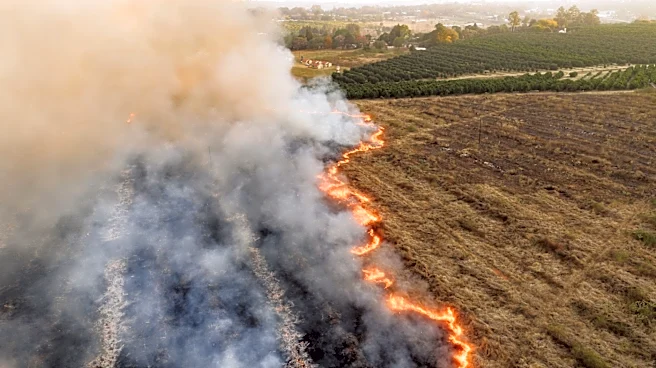
- Warmer, drier conditions in parts of the North and West: Strong El Niño events have historically favored warmer and drier conditions across parts of the Northwest, Northern Plains and Upper Midwest. That could prolong drought in some areas and increase wildfire concerns if dry conditions persist.
- Hurricane season impacts: El Niño can also influence tropical activity. In the Atlantic, stronger upper-level winds can disrupt developing storms, often reducing hurricane activity. In the eastern Pacific, El Niño typically creates a more favorable environment for tropical storms and hurricanes because of warmer waters, increased low-level spin and reduced wind shear.
- Hawaii wildfire concerns: El Niño’s impacts can also extend beyond the mainland. Increased summer rainfall can encourage grass growth, but if conditions later turn dry, that vegetation can become fuel for wildfires.
How El Niño develops
El Niño doesn’t start on a fixed date. It begins when sea surface temperatures in the tropical Pacific warm above average and stay elevated for several months, signaling a shift in both ocean and atmospheric patterns.
They also don’t occur on a strict schedule. They tend to emerge irregularly every two to seven years, depending on how ocean temperatures, wind patterns and broader climate conditions evolve.
Most El Niño events typically form between March and June, strengthen through summer and into fall, peak between November and January, and fade in late winter and spring.
How long does El Niño last?
El Niño is usually a one-season-to-one-year event, not a multi-year climate phase like La Niña can sometimes appear to be in extended cycles, according to NOAA.
In the current outlook, conditions are already present. They are expected to strengthen during the Northern Hemisphere winter of 2026–27, suggesting this event could persist from its development phase in 2026 into early 2027 before gradually weakening.
U.S. weather watches and warnings map
Stay informed. Get weather alerts via text
Brandi D. Addison covers weather across the nation as the Weather Connect reporter for the USA TODAY Network and contributes to Texas Connect coverage across the state. She can be reached at baddison@usatodayco.com. Follow her on Facebook here.
This article originally appeared on USA TODAY: What Super El Niño forecast could mean for winter in Ohio