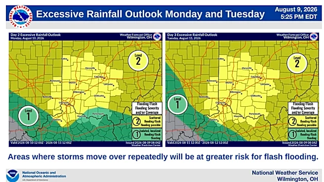








An active stretch of weather is underway across the Cincinnati area and will continue through at least midweek. Multiple rounds of showers and thunderstorms are expected, with the potential for damaging wind gusts, torrential rainfall, and localized flooding.
Monday: Severe storms, heavy downpours possible
A few thunderstorms could develop during the morning, but the greater threat arrives later in the afternoon and evening as stronger storms move into the region.
Multiple rounds of thunderstorms will be possible today into tonight. The greater potential for severe storms and heavy rain will be this afternoon into the evening, possibly lingering into the overnight hours. pic.twitter.com/jvC7l814j9
— NWS Wilmington OH (@NWSILN) August 10, 2026
Some storms may become severe, producing damaging winds and heavy downpours. Additional thunderstorms
could continue overnight.
Flash flooding is a concern, according to a hazardous weather advisory issued by the National Weather Service in Wilmington.

Tuesday: Threat of damaging winds, flash flooding
The forecast remains highly dependent on how Monday night's storms evolve, but confidence is growing that Tuesday could be another active severe weather day, according to the National Weather Service in Wilmington.
Thunderstorms may already be ongoing in the morning before additional development during the afternoon and evening.
Any stronger storm complexes could bring widespread damaging winds, intense rainfall, and even a few brief tornadoes. Repeated rounds of storms may lead to flash flooding concerns.
Wednesday, Thursday: Storms move south, flooding possible
Thunderstorm chances continue, especially during the Wednesday afternoon and evening. While the overall severe weather threat may begin shifting south of Cincinnati, heavy rain remains possible. Areas that receive multiple rounds of rainfall could experience flooding problems, particularly in low-lying and poor-drainage locations.
Additional scattered thunderstorms remain possible on Thursday. By this point, cumulative rainfall from earlier in the week could lead to rising creeks and rivers, increasing the risk of river flooding in some locations.
Drying out
A drier pattern is expected to develop Friday into Saturday as a stronger weather system pushes east and allows less humid air to move into the Ohio Valley.
This should provide a welcome break from the repeated rounds of storms.
This article originally appeared on Cincinnati Enquirer: Rounds of storms in Cincinnati forecast. Severe weather, flooding possible