


The nation's largest public art festival will soon take over the streets of Cincinnati and Northern Kentucky.
Blink takes place each night from Thursday, Oct. 8, through Sunday, Oct. 11, this year. And with it comes lots of road closures. The bright side? Covington is introducing a Dora-like district for pedestrians in special areas where roads are closed. So be sure to take advantage.
Here's how to get around Blink Cincinnati 2026, including a list of road closures, transportation options and Covington's new drink-friendly district.
Cincinnati road closures
The following streets will be closed for Blink Run the Night on Tuesday, Oct. 6, ahead of the festival. The streets will close at 6:30 p.m. and reopen at 9 p.m.
- Elm Street: Closed between Fourth Street and Fifth Street (closes at 4:30 p.m. for start/finish line construction).
- Elm Street: Closed between Fifth Street and Mehring Way.
- Fifth Street: Closed between Central Avenue and Race Street.
- Fourth Street: Closed between Race Street and Plum Street.
- Third Street: Westbound closed between Race Street and Plum Street.
- Second Street: Closed between the Clay Wade Bailey Bridge and Race Street.
- Central Ave.: Southbound closed between Seventh Street and Fifth Street.
- Central Ave.: Northbound closed between Third Street and Fifth Street.
- Freedom Way: Closed between Elm Street and Race Street.
- Mehring Way: Closed between Central Avenue and East Pete Rose Way.
- Johnny Bench Way: Closed.
- E Pete Rose Way: Closed west of Broadway.
The following streets will be closed for the Ready, Set,
Blink! Opening Ceremony Thursday, Oct. 8, from 4-9:30 p.m.
- Central Parkway: Closed between Liberty Street and Ezzard Charles Drive (closes at 6 a.m. for block party construction).
- Central Parkway: Closed between Liberty Street and Elm Street.
- Fourteenth Street: Closed west of Elm Street.
- Magnolia Street: Closed west of Elm Street (local access maintained but no access to Central Parkway).
- Fifteenth Street: Closed west of Elm Street (local access maintained but no access to Central Parkway).
- Odeon Street: Closed west of Elm Street (local access maintained but no access to Central Parkway).
- Wade Street: Closed west of Elm Street (local access maintained but no access to Central Parkway).
The following streets will close nightly from 7-11 p.m. Friday-Sunday, Oct. 9-11:
North-South streets:
- Elm Street: Closed between Central Parkway and Findlay Street (Liberty Street remains open to east-west traffic).
- Race Street: Closed between Central Parkway and Findlay Street (Liberty Street remains open to east-west traffic).
- Vine Street: Closed between Third Street and Central Parkway (Third Street, Fifth Street, Sixth Street, Ninth Street remain open for east-west traffic).
- Walnut Street: Closed between Third Street and Central Parkway (Third Street, Fifth Street, Sixth Street, Ninth Street remain open for east-west traffic.
- Main Street: Closed between Second Street and Twelfth Street (Second Street, Third Street, Fifth Street, Sixth Street, Ninth Street and Central Parkway remain open for east-west traffic). Main Street will close to maintain the streetcar.
- Jackson Street: Closed between Twelfth Street and Central Parkway.
East-West streets:
- Fourth Street: Restricted between Main Street and Race Street. The street will remain open as long as possible but may close due to crowd congestion.
- Seventh Street: Restricted between Main Street and Race Street. The street will remain open as long as possible but may close due to crowd congestion.
- Charles Street: Closed between Central Parkway and Elm Street.
- Twelfth Street: Closed to through traffic between Main Street and Central Parkway.
- Fourteenth Street: Closed between Central Parkway and Vine Street.
- Grant Street: Closed to through traffic between Central Parkway and Elm Street.
- Magnolia Street: Closed to through traffic between Central Parkway and Elm Street.
- Odeon Street: Closed to through traffic between Central Parkway and Elm Street.
- Wade Street: Closed to through traffic between Central Parkway and Elm Street.
- Green Street: Closed to through traffic between Vine Street and Elm Street.
- Elder Street: Closed between Vine Street and Central Parkway.
In addition to these street closures during Blink Festival hours, the following blocks will close and remain closed for the entire week:
- Freedom Way: Closed between Race Street and Marian Spencer Way (Rosa Parks Street will remain open during non-event hours).
- Plum Street: Closed between Ninth Street and Eighth Street.
- Court Street: Closed between Race Street and Walnut Street (Vine Street will remain open during non-event hours).
- Jackson Street: Closed between Twelfth Street and Thirteenth Street.
- Elder Street: Closed between Campbell Street and Elm Street.
The suspension bridge will also be closed nightly from 7-11 p.m. Cincinnati Police Department officers will help maintain local residential access. Additional streets may close as needed for traffic volumes. The streetcar service will be maintained.
How to access Cincinnati during Blink
From the East Side
Use the Metro Park & Ride service available nighty from 6 p.m.-12 a.m. at Crossroads Oakley, 3500 Madison Road.
From the Clifton area
Use the Metro Park & Ride service available nightly from 6 p.m.-midnight at Cincinnati State, 3658 Central Parkway.
From the northern suburbs
Use the Butler County Regional Transit Authority Park & Ride service available nightly from 5:30 p.m.-11 p.m. at the following locations:
- Meijer, 3651 Towne Blvd., Middletown.
- Meijer, 7390 Tylersville Road, West Chester.
Additional options
Pedestrians can use Metro, Butler County Regional Transit Authority, the Transit Authority of Northern Kentucky (TANK) and Red Bike.
Discounted Blink passes are available through the Transit app. For more information, visit: blinkcincinnati.com/resources/park-and-ride.
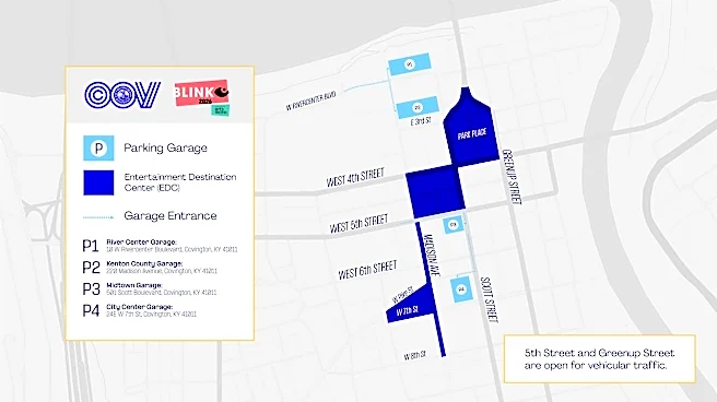
Covington road closures
The city of Covington released the following Blink road closures, effective Oct. 3 at 8 a.m. through Monday, Oct. 12 at 5 p.m.
- Park Place: Closed from Scott Street to Greenup Street.
- Court Street: Closed.
The following road will be closed beginning at 8 a.m. on Oct. 5, through 5 p.m. Tuesday, Oct. 13:
- Tobacco Alley from Madison Avenue to Scott Street.
The following roads will close nightly from 6 p.m. to 11 p.m. from Thursday, Oct. 8, through Sunday, Oct. 11.
- Roebling Way and the Roebling Bridge.
- E. Third Street: Closed from Scott Street to Greenup Street.
- Electric Alley: Closed from E. Fourth Street to E. Fifth Street.
- W. Pike Street: Closed from Washington Street to Madison Ave.
In addition to the closures above, the city's Entertainment Destination Center (EDC) will include the following streets closed to vehicle traffic:
- E. Fourth Street: Closed from Madison Avenue to Greenup Street.
- Scott Street: Closed from E. Third Street to E. Fifth Street.
- Madison Ave.: Closed from E. Fourth Street to E. Eighth Street.
- W. Seventh Street: Closed from Washington Street to Madison Ave.
West Fifth Street and Greenup Street will remain open to vehicle traffic.
What is Covington's Entertainment Destination Center?
The Entertainment Destination Center, also known as EDC, is an area of Covington where pedestrians can carry open containers of alcohol in specially marked cups.
The EDC will be in operation throughout Blink, Oct. 8-11, from 7-11 p.m. each night. Participating businesses will serve customers in the specially marked cups.

The following businesses are participating in Covington’s EDC:
- Agave & Rye
- Braxton Brewing Company
- Carmelo’s Restaurant
- Covington Yard
- dEcORa
- Dice on Draft
- FrostHaus
- The Globe
- The Hannaford
- Knowledge Bar and Social Room
- KungFood Amerasia
- Revival Vintage Bottle Shop and Bar
- Ripple Wine Bar
- Smoke Justis
- The Well
- Up There
- Wabi Sabi
- Wenzel Distillery
How to access Covington during Blink
From Cincinnati
Pedestrians will be able to use the Roebling Suspension Bridge to travel between Covington and Cincinnati.
Drivers can use the Clay Wade Bailey Bridge and Brent Spence Bridge.
From Newport
Pedestrians and bicyclists can use the free TANK Licking River Link shuttle, which connects Newport and Covington with stops on both sides of the Licking River.
Drivers should use the Girl Scout Bridge (KY 1120/11th Street).
Additional options
Use TANK, the Transit Authority of Northern Kentucky public bus system. TANK will offer special Blink Park & Ride service from Northern Kentucky University on Friday, Oct. 9, and Saturday, Oct. 10. Regular TANK routes will also operate throughout the festival.
Use rideshare options such as Uber and Lyft.
Use a GEST cart. The Green Easy Safe Transportation's free, on-demand electric carts move between Covington and Newport.
This article originally appeared on Cincinnati Enquirer: What roads are closed for Blink? See full list, transportation routes