






A new study has found coastal forest loss along parts of the N.C. coast has accelerated in recent years, and may still be speeding up.
The study by researchers from N.C. State University focused on the Albermarle-Pamlico Peninsula in the northeastern part of the state. Using satellite imagery, researchers found that the coastal region lost more than 20% of its coastal forest between 1985 and 2021, with losses increasing between 2010 and 2021.
Titilayo Tajudeen, lead author on the study and a graduate researcher at N.C. State, said sea-level rise was the chief driver of the forest loss. Strong tropical storm strikes, including Hurricane Irene in 2011, engineering of the landscape to drain it for agricultural uses that also allows salt water to push
farther inland, and several drought events over the years also contributed to the habitat loss.
The most pronounced losses were within a mile of so of the coast, with the proliferation of "ghost forests" even greater than the general forest loss.
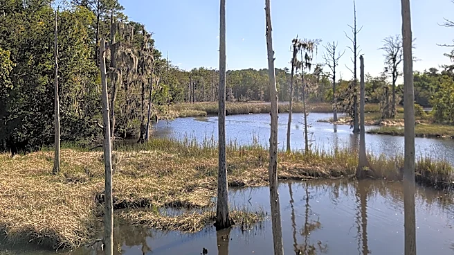
The sight of dead and dying trees is a common sight in the Wilmington area, especially around the lower Cape Fear River watershed and along the region's tidal creeks and brackish channels. The tall, grayish-white, often limbless sentinels that rise from the marshes are especially pronounced just north of downtown Wilmington in and around Smith Creek, where acres of old cypress groves are gone or just barely holding on.
These forests of tree skeletons can be found all along the coasts of North Carolina, South Carolina, Georgia and the Chesapeake Bay tracking north, and their ranks are growing as climate change combines with natural events and man's engineering of the coast to allow salt water to seep farther and farther inland. According to the N.C. State study, the rate of coastal forest retreat along parts of the U.S. East Coast is 2 to 14 times greater than pre-industrial rates.
What are ghost forests?
Ghost forests represent areas where the marsh and vegetation hasn't been able to keep up with an increased exposure to salinity. The salty water slowly poisons the trees, leaving them as graying pillars of environmental change before they eventually collapse.
While some trees like cypress and some cedars can survive in brackish waters, too much salt can cause widespread tree death.
The saltier water, beside changing freshwater to saltwater wetlands, also eats away at the marshes, dissolving and washing the soil away, accelerating erosion along shorelines. A very visible sign of this is along the Northeast Cape Fear River north of downtown Wilmington near the Interstate 140 bridge, where increased tidal exchanges and sea-level rise tied in part to the deepening of the Cape Fear River shipping channel has seen the river's footprint widen significantly.

Why are ghost forests increasing?
While some habitat transformation would be expected under natural conditions, man's decades of pumping millions of tons of heat-trapping greenhouse gases into the atmosphere has changed the world's weather patterns.
The warming planet has increased the melting of the ice caps, raising sea levels and allowing salt water to reach farther inland and in greater quantities. Rising ocean temperatures also are contributing to the problem, since the volume of the ocean is expanding as the sea water warms.
Climate change means stronger and bigger tropical weather systems, where amplified storm surge pushes water father onto land and up waterways. For example, the highest readings ever at the Wilmington tide gauge, which sits at the foot of the Cape Fear Memorial Bridge and has been in operation since 1908, were recorded during 2020's Hurricane Isaias, a relatively small Category 1 storm.
Increasing and more persistent periods of drought, another sign of climate change, also means there's sometimes less freshwater to counter the impacts of the salt water pulses. North Carolina has experienced several periods of extended drought in recent years, including for much of 2026.
Researchers at the Virginia Institute of Marine Science measuring coastal forest retreat rates using historical maps and core samples have seen it jump from less than 0.5 meters (1.6 feet) per year in parts of North Carolina prior to 1875 to more than 4 meters (13 feet) in places today.

What does it mean for the environment?
Ghost forests don't provide the range of habitat for freshwater and saltwater flora and fauna that a healthy coastal forest and brackish environment does. Researchers are still trying to determine the long-term impacts from these changes to coastal systems on migrating birds, insects, invertebrates, and other critters and plants that call them home.
Ghost forests also can't provide the protection that a healthy forest does by helping absorb the wind and water energy from hurricanes and other strong weather events. That's because as the trees die and other organic material in the wetlands succumbs to the increased salinity in the water, the marshes start falling apart and washing away.
"If I was putting it on a scale, I wouldn't say there are too many benefits from those habitat changes," said Dr. Andrea Hawkes, a geologist and oceanographer at the University of North Carolina Wilmington.
The wetlands also are great carbon sinks, but that capability is lost as they are washed away. A 2021 study by N.C. State researchers found that ghost trees, colloquially called snags, increased greenhouse gas emissions of the overall decomposing wetland ecosystem by about 25%.

N.C. State study findings
The study published in September 2026 in the PLOS One scientific journal used imagery from two different satellites to determine coastal forest loss between 1985 and 2021.
Researchers determined the peninsula's forest loss to be 42,000 acres between 1985 and 2010 and nearly 60,000 acres between 2010 and 2021.
Tajudeen said there are likely several reasons the transition of coastal forest areas on the peninsula to marsh, ghost forest and shrub sped up in recent years. While natural events, like tropical storms, played a role, she said there's no doubt human fingerprints also played a part in the habitat loss, with a warming climate due to greenhouse gas emissions accelerating sea-level rise, producing bigger and stronger tropical storm events, and increasing the duration and number of drought events.
The punch after punch of events simply didn't allow some areas to recover, which they might have done in the past.
While northeastern N.C. is a known hotspot for coastal shoreline loss due to its low-lying, flat topography and that its sandy, marshy land is sinking just as sea-level rise increases, increased coastal forest loss and erosion woes are a problem along much of the N.C. coast − including in the Wilmington area.
"What we're seeing in places like Smith Creek is really a harbinger of what's going to come," Hawkes said. "We're really seeing these wetlands change before our eyes."
Tajudeen said researchers hope the study and future work will allow officials to focus on how and where to take steps to stop, or at least slow down, the coastal forest loss. In short, instead of just practicing coastwide solutions like planting more saltwater-resistant trees ahead of areas that will likely be inundated in the coming years, pick certain areas to use your finite financial and manpower resources that offer a greater chance of success.
"If we know what's happened and what might happen and where, we might be able to focus on those areas that we view as more critical, more important," Tajudeen saidReporter Gareth McGrath can be reached at GMcGrath@usatodayco.com or @GarethMcGrathSN on X/Twitter. This story was produced with financial support from Journalism Funding Partners. The USA TODAY Network maintains full editorial control of the work.
This article originally appeared on Wilmington StarNews: NC’s coastal forests are dying. Why the pace may be accelerating.