



A new U.S. 17 connection is on the way for northern Brunswick County.
As Brunswick officials weigh transportation priorities for the N.C. Department of Transportation's next State Transportation Improvement Program, a long-discussed connector road between U.S. 17 and N.C. 133 will likely be surfaced by a developer first.
N.C. 133, also called River Road, extends from Belville to Oak Island, serving as a major thoroughfare and evacuation route. Though a majority of the route remains untouched by development, a golf course, convenience store, and school are located along the route, as well as several homes, neighborhoods and parks.
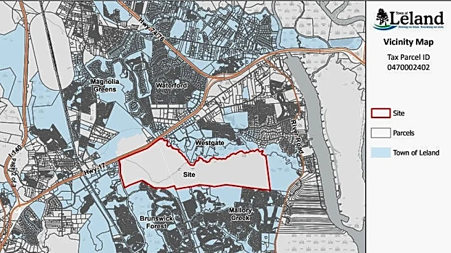
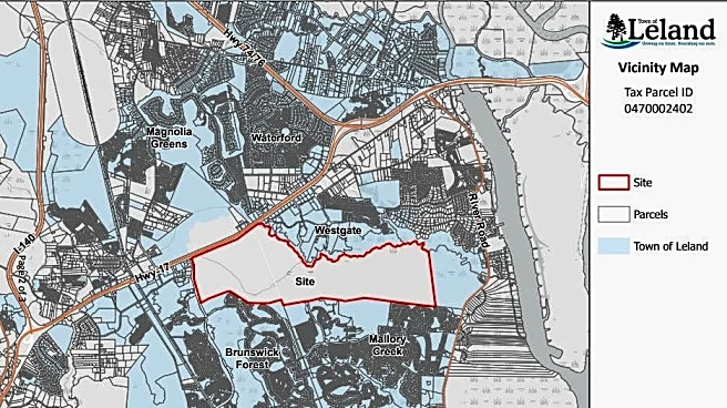
The proposed route, known in regional planning documents as the U.S. 17/N.C. 133 Connection, shows a new roadway linking
the two highways. The NCDOT P8 Prioritization Map shows their proposed roadway starting near Egret Nest Circle, cutting through Mallory Creek and the Jackey's Creek property, and landing between Brunswick Forest and the West Gate shopping center.
Community members who provided input to the NCDOT on the project said the additional route is "badly needed" and "overdue." Construction of more homes and a school will only increase the congestion.
The proposed Jackey's Creek development, which received annexation and rezoning approval from the town of Leland in 2025, includes plans for residential and commercial development, a future elementary school site, as well as a connector road between U.S. 17 and N.C. 133.
An existing road connects Mallory Creek and Brunswick Forest to both highways. However, the new roadway will serve as the main access for the upcoming development.
The N.C. 133 and U.S. 17 corridor has appeared in local transportation planning documents for years. Transportation planners with the Wilmington Urban Area Metropolitan Planning Organization (WMPO) identified the corridor as a possible future connection several years ago. The project is in the organization's Cape Fear Navigating Change 2050 project list and is identified as a project included in the Town of Leland's 2013 Collector Street Plan.
Leland Town Manager David Hollis said the project has been looked at in many different ways, but has not received state funding. With the NCDOT State Transportation Improvement Program being a 10-year, multi-step process for funding, Hollis said the Jackey's Creek developer is planning to obtain right-of-ways and bring the project to life.
"They're looking to move forward," Hollis said. "Something major would have to happen for them not to want to move forward at this point."

Belville Mayor Chuck Bost said the route would come with positives and negatives. However, he believes existing infrastructure for N.C. 133 needs to be addressed before future development adds more traffic to N.C. 133.
"N.C. 133 is a hurricane evacuation route, and the road that's there right now is inadequate for that," Bost said.
The developer is currently working with the town of Leland and the NCDOT to develop a detailed design and plan for the road, said Hollis, noting more information is expected to be available in the next six months.
"It's very likely that the developer would build a two-lane road and there would be enough right-of-way for it to be expanded in the future to a four-lane road," said Hollis, noting the expansion, if decided, would be a public entity's responsibility.
While the design of the development's road is not finalized, the NCDOT's proposal aligns with a separate proposal to construct a new river crossing south of the existing Cape Fear Memorial Bridge. Other projects under the NCDOT's consideration include widening N.C. 133 to a four-lane road from Blackwell Road to Rabon Way.
STAY (ROAD) CONNECTED: Keep up with the area’s latest Brunswick County news by signing up for the Brunswick Today newsletter and following us on Facebook and Instagram.
Savanna Tenenoff covers Brunswick County for the StarNews. Reach her at stenenoff@usatodayco.com.
This article originally appeared on Wilmington StarNews: How a new road could add another link for Belville and Leland