



A hurricane in the Gulf of Mexico is on its way to the southeast, and while most Georgians won't get the full force, everyone should expect a stormy weekend.
The National Weather Service issued a tropical storm warning for five counties in the corner of southwest Georgia, a tropical storm watch for much of southwest Georgia (including Columbus and Americus), a hazardous weather outlook for a huge portion of north and middle Georgia (including Atlanta and Macon), and a high wind watch for Atlanta, Athens, and other parts of north Georgia.
A tropical storm watch is issued when tropical storm conditions are a possible threat within 48 hours, while a warning issued when those sorts of conditions are certainty that can be expected in 36 hours or less.
Conditions in both the watch and warning areas are favorable for tornadoes with local peak winds north of 10-15 mph and 40 mph guests, but there is a potential for 39-57 mph winds. Flooding rain is also possible.
Areas under the hazardous weather outlook should expect some form of impact Friday through early Sunday including flood-level rains, strong gusty winds, and possible tornadoes. However, there is still some uncertainty of the exact magnitude of the local impact.
But even residents not currently under an NWS advisory shouldn't expect a break. Augusta and Savannah can both expect rain to start late Friday but especially coming down on Saturday through Sunday with winds around 17 mph and gusts potentially crossing 30 mph. Thunderstorms are also possible. The weather may start to weaken Sunday evening for Augusta, but will probably stay strong in Savannah.
Where is Hurricane Isaias now
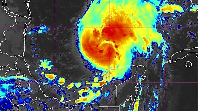
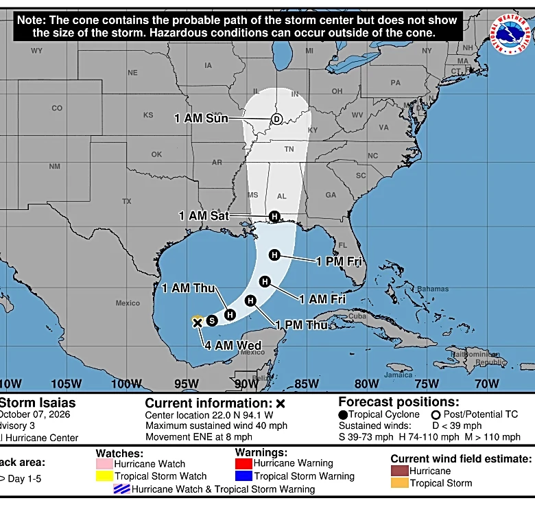
As of 8 a.m., the center of Isaias was 385 miles south-southwest of the mouth of the Mississippi River, and moving to the east-northeast at 9 mph. Its maximum sustained winds were 80 mph, making it a Category 1 storm.
Tropical Storm Isaias forecast
The hurricane center warned Isaias is likely to continue a period of rapid strengthening before reaching the coast somewhere between Pascagoula MS and Panama City Beach, Florida, on Friday evening. Isaias could have winds of over 100 mph as it approaches the coast, then dramatically weaken. It's forecast to peak before making landfall.
"Regardless, Isaias is expected to remain a dangerous hurricane through landfall, and gusty winds are expected well inland after landfall," the hurricane center said in a forecast discussion Thursday morning.
Tropical Storm Isaias spaghetti models
Here is a USA Today Co. spaghetti model for Isaias:
Explain the timeline and path of Tropical Storm Isaias in 2020
Back in 2020, parts of America got hit by another storm named Isaias. It made landfall at Ocean Isle Beach, NC on Monday, Aug. 3 as a Category 1 hurricane with maximum sustained winds of 85 mph.
It moved quickly north through the Mid-Atlantic, bringing significant impacts up and down the East Coast including 46 confirmed tornadoes from South Carolina to Connecticut. Flooding and heavy gusts were also reported. It finally dissipated on Aug. 5 in Canada.
How to pronounce Isaias
The National Hurricane Center says Isaias should be pronounced as ees-ah-EE-ahs.
Isaias name meaning
According to The Bump, the origin Isaias is Hebrew and means "salvation of God" or "God is my salvation." It's also an alternative spelling for Isaiah.
Miguel Legoas is a Deep South Connect Team Reporter for USA Today. Find him on Instagram @miguelegoas and email at mlegoas@gannett.com.
This article originally appeared on Savannah Morning News: Where is Hurricane Isaias now? See watches, warnings issued in Georgia