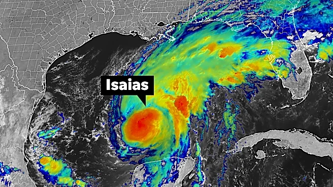


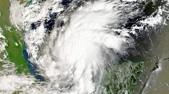
Hurricane Isaias has strengthened into a powerful Category 3 storm and continues to intensify. According to the National Hurricane Center’slatest 11 a.m. update, maximum sustained winds have increased from 120 mph at 8 a.m. to 150 mph. The storm is also picking up speed, raising concerns about its potential impacts as it moves toward the coast.
The biggest part of the storm is expected to make landfall late Friday, between 7 and 9 p.m., moving further east of Pensacola, per the latest update.
The National Hurricane Centerexpects Isaias to make landfall as a Category 3 hurricane or a strong Category 2. Storm surge remains one of the biggest concerns, with 6 to 9 feet possible in some areas, increasing the risk of significant coastal flooding. To
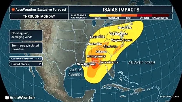
make matters worse, the storm’s expanding wind field could also bring dangerous conditions well beyond the coast. Forecasters say that because Isaias is moving quickly, damaging winds could extend far inland, with winds reaching up to 50 mph possible in areas as far away as Birmingham, Atlanta, and parts of Tennessee.
So, while Jacksonville is clear of landfall impacts, heavy rain, flooding and wind gusts still remain a concern. Here’s what to expect.
➤ Track Hurricane Isaias
What impacts can Jacksonville expect from Isaias?
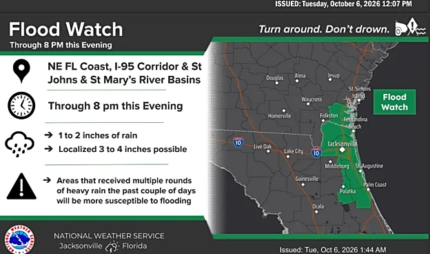
Stormy weather and heavy rainfall will continue across the Jacksonville area, with a Flood Watch in effect for all of Southeast Georgia and Northeast Florida. In Northeast Florida, the watch remains in effect through tonight, with 1 to 3 inches of rain expected and locally higher amounts possible.
Jacksonville is also under a Coastal Flood Advisory until 2 p.m. Saturday. Looking ahead, isolated severe thunderstorms are possible Saturday and could continue throughout the day. The main threats include strong wind gusts and the potential for brief tornadoes.
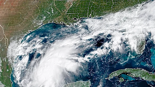
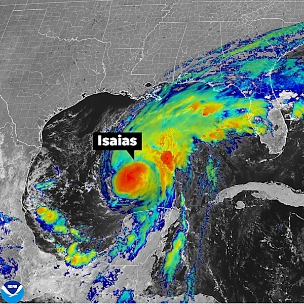
According to the National Weather service, swells from Isaias are affecting the western and northern portions of the Yucatan peninsula and will spread northward toward the Gulf Coast today, causing life-threatening surf and rip current conditions. See image below.

What's the latest on Isaias?
Hurricane Isaiasstrengthened into a major Category 3 hurricane with maximum sustained wind speeds of 150 mph, according to a 11 a.m. alert from the National Hurricane Center on Oct. 9, with the storm increasing its speed by 1 mph.
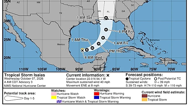
Forecasts suggest Isaias could encounter wind shear before making landfall. According to the latest update, the storm’s main impacts are expected to reach the coast late Friday, between 7 and 9 p.m., with the projected landfall shifting farther east of Pensacola.
See graphics of Hurricane Isaias for path, rain potential impacts
Where Isaias expected to land? where?
Landfall is likely to be near Pensacola, probably near midnight, said Ryan Truchelut, chief meteorologist at WeatherTiger, who works with the USA TODAY Network.
"During this time, the wind field is also predicted to grow due to the trough interaction, and some of these impacts will extend well away from the center."
➤ Isaias: A threat level breakdown for North Florida
Isaias is headed for the Northern Gulf Coast, what residents should know
Isaias is a dangerous hurricane,and residents can expect "significant storm surge, damaging winds, and flooding rains when it reaches the northern Gulf Coast," according to the National Hurricane Center, which also encouraged residents to prepare for power outages.
➤ Weather alerts via text: Sign up to get updates about current storms and weather events by location
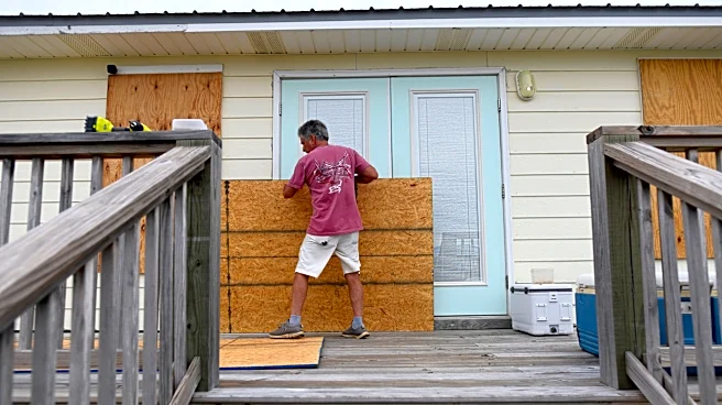
Residents should quickly finish preparing for the storm. Tropical storm conditions are expected in the warning areas beginning in the next few hours, the Hurricane Center said at 8 a.m.
Gov. Ron DeSantis on Oct. 8 expanded a state of emergency to 27 counties.
Isaias is the ninth named storm of the 2026 Atlantic hurricane season and the first hurricane.
Here's the latest information from the National Hurricane Center on Isaias.
Where is Hurricane Isaias?
- Location: 240 miles south of Pensacola
- Winds: 120 mph
- Movement: north-northeast at 15 mph
- Pressure: 959 mb
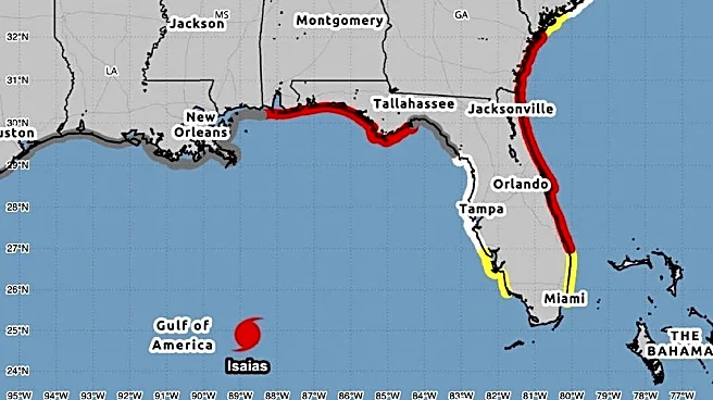
At 8 a.m., the center of Hurricane Isaias was located near latitude 27.0 North, longitude 87.7 West. Isaias is moving toward the north-northeast near 15 mph. A turn toward the north is expected later today.
On the forecast track, Isaias is expected to approach the U.S. northern Gulf Coast this afternoon and make landfall within the warning area tonight or early Saturday.
Data from an Air Force Reserve Hurricane Hunter aircraft indicate that maximum sustained winds are near 110 mph with higher gusts. Isaias is likely to become a major hurricane this morning and remain a dangerous hurricane at landfall this evening or tonight.
Hurricane-force winds extend outward up to 30 miles from the center, and tropical-storm-force winds extend outward up to 185 miles (295 km).
The minimum central pressure based on dropsonde data from the reconnaissance mission is 959 mb (28.32 inches).
Spaghetti models for Hurricane Isaias
Special note about spaghetti models: Spaghetti model illustrations include an array of forecast tools and models, and not all are created equal. The Hurricane Center uses only the top four or five highest performing models to help make its forecasts.
What impacts could Isaias have on Florida?
Isaias is expected to bring life-threatening storm surge, damaging hurricane-force winds, heavy rain and a possibility for tornadoes.
Here's a breakdown of what impacts Florida could see from Hurricane Isaias, according to Truchelut:
Storm surge: This is the deadliest of hurricane threats, and one many people overlook as they focus on winds.
"Areas along and just east of the likely landfall range, roughly from Gulf Shores, Alabama, to Panama City are at the greatest risk of destructive surge impacts. These areas are likely to see anywhere from to 4 to as much as 7 feet of storm surge, exacerbated by an unfavorable timing of high tide on Friday night between 11 p.m. and midnight," Truchelut said.
Wind: "All the warned regions should prepare for hurricane-force winds, but the strongest likelihood of peak wind gusts of 75 to 100 mph range is in southern Alabama and the western Panhandle tomorrow night, especially on the coastline between roughly Dauphin Island to just east of Destin."
Tornadoes: "The extreme westerly wind shear Isaias will encounter Friday evening is something that weakens hurricanes, but is also going to create a very favorable environment for tornadoes to develop in the outer bands of the eastern half of the storm."
Rainfall: "Isaias is also going to be a significant rainmaker, though storm accumulations will be limited by its fast forward speed at landfall and dry air on the south side of the storm. Through Sunday morning, the heaviest precipitation totals will fall between Mobile and Tallahassee, generally ranging from 3-6 inches with the potential for localized amounts of up to 10 inches," Truchelut said.
Watches and warnings issued for Hurricane Isaias
Hurricane warnings:
- Ocean Springs, Mississippi, to the Bay/Gulf County Line in Florida
Storm surge warnings:
- Mouth of the Mississippi River to the Suwannee River
Storm surge watches:
- Suwannee River to Yankeetown in Florida
Tropical storm warnings:
- Jefferson/Plaquemines Parish Line, Louisiana, to west of Ocean Springs, Mississippi
- East of Bay/Gulf County Line to Aucilla River in Florida
Hazards affecting land associated with Hurricane Isaias
Storm surge: The combination of a dangerous storm surge and the tide will cause normally dry areas near the coast to be flooded by rising waters moving inland from the shoreline. The water could reach the following heights above ground somewhere in the indicated areas if the peak surge occurs at the time of high tide:
The water could reach the following heights above ground somewhere in the indicated areas if the peak surge occurs at the time of high tide:
- Alabama/Florida border to Grayton Beach, Florida: 6-9 ft
- Dauphin Island, Alabama to Indian Pass, Florida: 4-6 feet
- Grayton Beach, Florida to Indian Pass, Florida: 4-7 ft
- Indian Pass, Florida to Steinhatchee River, Florida: 4-6 feet
- Steinhatchee River, Florida, to Suwannee River, Florida: 3-5 feet
- Mouth of the Mississippi River, Louisiana to Dauphin Island, Alabama: 3-5 ft
- Mobile Bay: 3-5 ft
- Suwannee River to Yankeetown, Florida: 2-4 feet
The deepest water will occur along the immediate coast near and to the east of the landfall location, where the surge will be accompanied by large and dangerous waves. Surge-related flooding depends on the relative timing of the surge and the tidal cycle, and can vary greatly over short distances.
Wind: Hurricane conditions are expected within the hurricane warning area tonight into early Saturday, with tropical storm conditions beginning later today. Tropical storm conditions are expected in the warning areas beginning in the next few hours.
Rainfall: Through the weekend, Isaias is expected to produce rainfall amounts of 4 to 8 inches across southern Alabama, the Florida Panhandle and Big Bend, and southwest Georgia. Localized totals up to 15 inches are possible, particularly within banding across the Florida Panhandle and Big Bend.
Across much of the remainder of the Southeast, rainfall amounts of 2 to 5 inches are expected. Localized higher amounts up to 10 inches are possible, especially across the Southern Appalachians and coastal Carolinas.
Flash and urban flooding is likely across the region, with considerable impacts possible across much of southern Alabama and the Florida Panhandle into southwestern Georgia.
River flooding is also expected, some of which could be significant.
Tornadoes: A tornado risk will begin late this afternoon and continue tonight in coastal areas of Alabama, the Florida Panhandle, and far southwest Georgia. The tornado threat will continue Saturday across parts of eastern Alabama, the Florida Panhandle, Georgia, and the Carolinas.
Surf: Swells from Isaias are affecting the western and northern portions of the Yucatan Peninsula and will spread northward toward the Gulf Coast later today. These swells are likely to cause life-threatening surf and rip current conditions.
Key messages about Hurricane Isaias from National Hurricane Center
Key messages associated with Hurricane Isaias:
- A life-threatening storm surge is expected from the Mouth of the Mississippi River to Suwannee, Florida. Residents in the warning area should follow advice given by local officials and evacuate immediately if told to do so.
- Damaging hurricane force-winds are expected over portions of the Florida Panhandle, southern Alabama, and southern Mississippi where a Hurricane Warning is in effect. Residents in these areas should prepare for the possibility of long-duration power outages.
- Damaging wind gusts are possible over much of central and northern Alabama, extreme eastern Mississippi, and portions of western and northern Georgia, especially in areas of higher terrain. Additional Tropical Storm and High Wind Watches and Warnings may be required for portions of that area later today. Residents should secure loose outdoor items, avoid driving high-profile vehicles, and prepare for power outages.
- Isaias will bring areas of heavy rainfall to the central U.S. Gulf coast and much of the Southeast through the weekend. Considerable flash and urban flooding, along with significant river flooding, will be possible.
How strong could Hurricane Isaias get?
As of 8 a.m. Oct. 9, expected wind speeds predicted for Isaias are:
- Initial: 110 mph
- 12 hours: 120 mph
- 24 hours: 75 mph, inland
- 36 hours: 40 mph, post-tropical
- 48 hours: 30 mph, post-tropical
- 60 hours: 15, post-tropical
- 72 hours: dissipated
See latest weather watches, warnings issued for Florida
Florida weather radar for Oct. 9, 2026

Stay informed. Get weather alerts via text
What's next?
We will continue to update our tropical weather coverage to bring you the most current information you need to protect your home and family.
Doris Alvarez is a Breaking and Trending Reporter for The Florida Times-Union. You can get all of Jacksonville’s best content directly in your inbox each weekday by signing up for the free Daily Briefing and News Alerts newsletters at jacksonville.com/newsletters
This article originally appeared on Florida Times-Union: When, where will Hurricane Isaias hit land? See Jacksonville impacts