



A powerful El Niño could influence Philadelphia's winter storm pattern this season, but that doesn't necessarily mean Delaware Valley residents should expect more snow.
El Niño can alter storm tracks across the United States, and a very strong event will likely shift the jet stream southward and eastward this winter, according to the National Oceanic and Atmospheric Administration's 2026-27 U.S. Winter Outlook
.NOAA expects wetter-than-average conditions along the East Coast, while warmer-than-average temperatures are favored across much of the East.
Those ingredients could affect winter storms around Philadelphia, but they don't add up to a seasonal snowfall forecast.
In fact, NOAA cautions that its seasonal outlook does not predict snowfall totals
because snow generally cannot be forecast more than about a week in advance. Here's everything to know as winter approaches.
What does El Niño mean for Philadelphia snow?
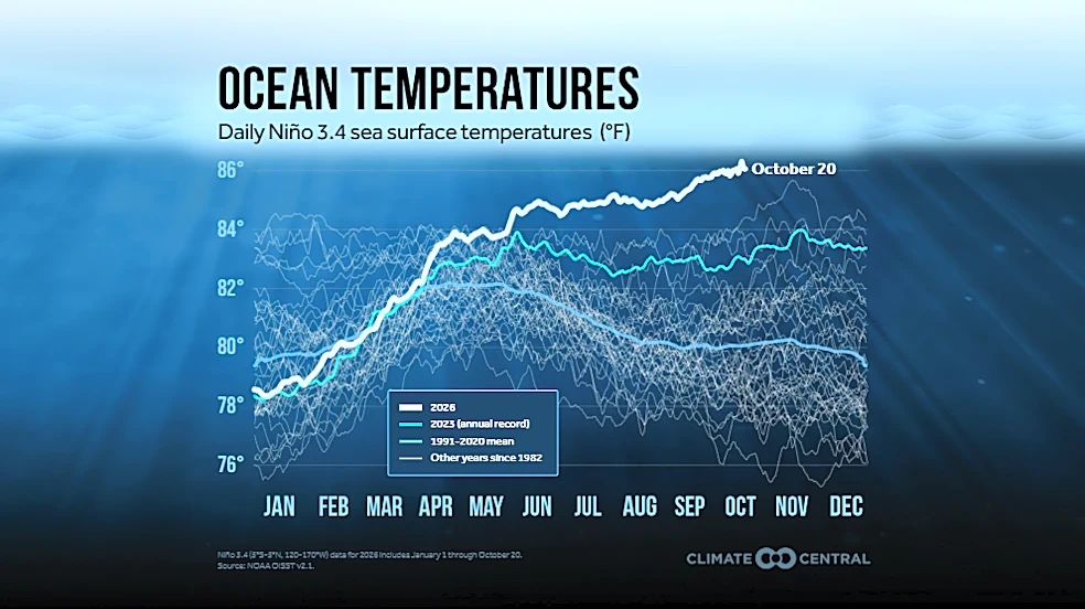
El Niño occurs when ocean temperatures near the equator in the eastern and central Pacific remain above average for an extended period. The resulting changes in the ocean and atmosphere can alter storm tracks and affect temperatures and precipitation around the world, according to AccuWeather’s 2026 El Niño analysis.
A strong El Niño typically strengthens and shifts the southern branch of the jet stream, raising the potential for wetter conditions across parts of the southern United States while favoring warmer conditions across portions of the North, AccuWeather reported.
NOAA's current winter outlook similarly favors wetter-than-average conditions along the East Coast.
Does a strong El Niño always mean more snow?
A wetter winter doesn't necessarily mean a snowier one.
NOAA's seasonal outlooks calculate the likelihood that total precipitation and temperatures will be above, near or below average. They do not project how much snow will fall during the season.
That distinction is particularly important around Philadelphia because NOAA's current outlook favors both wetter-than-average conditions along the East Coast and warmer-than-average temperatures across much of the East.
So while El Niño could help create an active winter weather pattern, exactly what falls from any particular storm can't be determined from the seasonal outlook alone.
What else determines how much snow Philly gets?
El Niño is only part of the larger weather picture.
AccuWeather says unusually warm waters in other areas of the Pacific could interact with El Niño and other large-scale atmospheric patterns, affecting the location and strength of winter storm tracks.
Ultimately, Philadelphia's snowfall will depend on the storms and temperatures that develop during the winter. NOAA notes that reliable snow forecasts generally aren't possible more than about a week ahead.
That means the developing El Niño may help set the stage for Philadelphia's winter, but it cannot tell residents months in advance whether the season will ultimately be a snowy one.
Damon C. Williams is a Philadelphia-based journalist reporting on trending, breaking and service-related topics across the Mid-Atlantic region for the USA Today Network.
This article originally appeared on Bucks County Courier Times: Does a strong El Niño mean more snow for Philadelphia this winter?