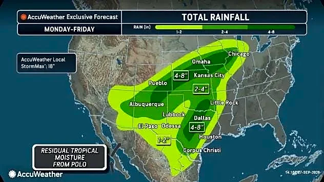

A slight flash flooding risk is expected in Corpus Christi by the night of Oct. 1.
According to the National Weather Service Corpus Christi, abundant moisture from the remnants of Hurricane Polo will interact
with a slow-moving cold front, leading to scattered to numerous showers and thunderstorms across the Corpus Christi region.
Flash flood risk will increase later into the week. River flooding is also possible, "but confidence is too low to include at this time."
As of about 5 a.m. Sept. 29, the forecast for the night of Oct. 1 includes a moderate risk of flash flooding west of Alice, with a slight risk of flash flooding — at least 15% — to the east, including Nueces, Kleberg, San Patricio and Aransas counties.
There is a marginal risk of flash flooding, at least 5%, in these coastal counties near Corpus Christi on the night Oct. 2, with a slight risk west of Falfurrias and Alice.
Temperatures are expected to remain above normal Sept. 29 and Sept. 30.
A heat advisory might be needed Sept. 30 across the coastal plains, according to a 6:24 a.m. Sept. 29 forecast discussion.
The Tuloso-Midway Independent School District announced that it was rescheduling homecoming festivities planned for the weekend due to the weather forecast.
As a result, an early release day planned for Oct. 1 had been rescheduled for Oct. 15, with homecoming festivities and events planned between Oct. 10 and Oct. 16.
This article originally appeared on Corpus Christi Caller Times: Heavy rainfall, flash flooding could hit Coastal Bend on Oct. 1