/images/ppid_59c68470-image-178842752628930457.webp)




What is the story about?
An earthquake of magnitude 5.0 struck Tibet on Thursday, September 3, 2026, according to the National Center for Seismology (NCS).
The earthquake was recorded at 13:46:38 IST, the NCS said in a post on X.
The earthquake occurred at a latitude of 31.479° N and longitude of 80.370° E, with a depth of 14 km.
The NCS identified the location of the earthquake as Tibet. The seismic activity was also shown on the NCS map in the region near Uttarakhand.
According to the information displayed on the NCS map, the earthquake was located 128 km north-east of Joshimath in Uttarakhand, India.
The NCS marked the earthquake as reviewed in its seismic information.
The map shared by the NCS showed the epicentre in the area north of Uttarakhand and close to the Himalayan region. The seismic activity was represented by coloured zones around the epicentre.
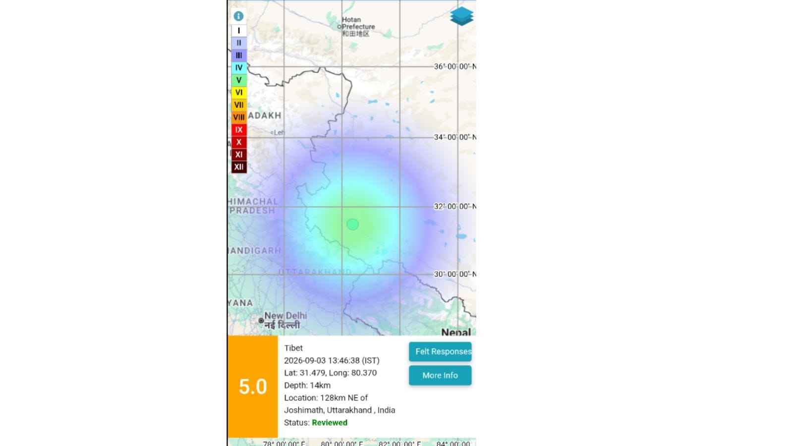
The earthquake was recorded at 13:46:38 IST on September 3, 2026, with the NCS listing its magnitude as 5.0 and depth as 14 km.
The coordinates provided by the NCS placed the epicentre at 31.479° N latitude and 80.370° E longitude.
The NCS shared the earthquake information through its official X account, @NCS_Earthquake, and directed users to the BhooKamp App for more information.
The earthquake information on the map also identified the location as Tibet and showed its proximity to Joshimath in Uttarakhand.
The NCS map displayed the seismic intensity around the earthquake’s epicentre, with the affected area extending towards parts of the Himalayan region.
The earthquake was recorded at a relatively shallow depth of 14 km, while the NCS classified the event with a magnitude of 5.0.
The earthquake was recorded at 13:46:38 IST, the NCS said in a post on X.
EQ
of M: 5.0, On: 03/09/2026 13:46:38 IST, Lat: 31.479 N, Long: 80.370 E, Depth: 14 Km, Location: Tibet. For more information Download the BhooKamp App https://t.co/5gCOtjdtw0 @DrJitendraSingh @OfficeOfDrJS @tummalasrini @GSuresh_NCS @ndmaindia pic.twitter.com/zwrE8sNscC
— National Center for Seismology (@NCS_Earthquake) September 3, 2026
The earthquake occurred at a latitude of 31.479° N and longitude of 80.370° E, with a depth of 14 km.
The NCS identified the location of the earthquake as Tibet. The seismic activity was also shown on the NCS map in the region near Uttarakhand.
According to the information displayed on the NCS map, the earthquake was located 128 km north-east of Joshimath in Uttarakhand, India.
The NCS marked the earthquake as reviewed in its seismic information.
The map shared by the NCS showed the epicentre in the area north of Uttarakhand and close to the Himalayan region. The seismic activity was represented by coloured zones around the epicentre.
The earthquake was recorded at 13:46:38 IST on September 3, 2026, with the NCS listing its magnitude as 5.0 and depth as 14 km.
The coordinates provided by the NCS placed the epicentre at 31.479° N latitude and 80.370° E longitude.
The NCS shared the earthquake information through its official X account, @NCS_Earthquake, and directed users to the BhooKamp App for more information.
The earthquake information on the map also identified the location as Tibet and showed its proximity to Joshimath in Uttarakhand.
The NCS map displayed the seismic intensity around the earthquake’s epicentre, with the affected area extending towards parts of the Himalayan region.
The earthquake was recorded at a relatively shallow depth of 14 km, while the NCS classified the event with a magnitude of 5.0.


/images/ppid_59c68470-image-178845010575726563.webp)