


What is the story about?

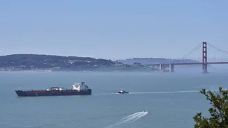
SAN FRANCISCO (AP) — Ferries, cargo ships, and tankers traversed the choppy waters of San Francisco Bay on Tuesday as a whale surfaced nearby, its spout
barely visible against the white caps. To address the risk of unnoticed whales, an AI-powered detection network launched this week aims to track them day and night. The system, known as WhaleSpotter, continuously scans the bay for whale blows and heat signatures up to 2 nautical miles away, alerting mariners to slow down or reroute when whales are in the vicinity.
“They'll be able to make adjustments way before they get anywhere close,” said Thomas Hall, director of operations for San Francisco Bay Ferry. “It will also allow us to track data over time and see where the whales are camping out so we can adjust our routes during whale season to avoid those areas completely.”This initiative arises amid a troubling increase in gray whale deaths in the bay. In the previous year, 21 dead gray whales were discovered in the broader Bay Area, marking the highest number in 25 years, according to The Marine Mammal Center, with at least 40% of these fatalities attributed to ship strikes. At least 10 more gray whales have died in the Bay Area this year.
Scientists indicate that these figures likely underestimate the actual toll, as many whale carcasses sink or drift back out to sea before being discovered or reported.
Gray whales have historically migrated along the California coast on their approximately 12,000-mile journey between breeding lagoons in Mexico and feeding grounds in the Arctic. However, a growing number are now diverting into San Francisco Bay, lingering for days or even weeks in the crowded estuary — a trend increasingly linked to climate change. Warming temperatures and changes in Arctic sea ice disrupt the food web that gray whales depend on during summer feeding months, according to a 2023 study published in Science, resulting in many whales being malnourished during migration.
Many whales now concentrate in a high-traffic corridor between Angel Island, Alcatraz, and Treasure Island, directly intersecting with ferry routes and shipping lanes. “It’s the worst place possible in terms of all the ship traffic,” remarked Rachel Rhodes, a project scientist at the Benioff Ocean Science Laboratory who led the initiative. The frequency of collisions has been so high that “the teams responding to strandings said they ran out of places to even land dead whales.”
The eastern North Pacific gray whale population was once regarded as a conservation success story after rebounding from commercial whaling and being removed from the Endangered Species Act in 1994. However, their numbers have since declined by half over the past decade, according to the National Oceanic and Atmospheric Administration, leaving just 13,000 remaining.
“They may not be getting the quality or quantity of food they’re used to in the Arctic,” Rhodes stated. “That means they’re starting this incredibly long migration at a disadvantage.”
Artificial intelligence automatically identifies potential whale sightings, which are then confirmed by trained marine mammal observers before alerts are dispatched via radio to ferry operators, vessel traffic controllers, and posted publicly on the Whale Safe website.
WhaleSpotter systems are already operational on vessels and fixed installations like lighthouses and coastal towers in the United States, Canada, and Australia. However, researchers assert that the San Francisco Bay network is the first to directly integrate land-based and vessel-mounted detections with official mariner alerts, enabling near-real-time communication of whale sightings to ships navigating the bay.
The initial hours of testing yielded a significant influx of detections. “Suddenly to have a full sense of how much whale activity is in this space honestly put me a little bit on edge,” said Douglas McCauley, director of the Benioff lab. “But we're going to use that data and we're going to be smart about how we use that space and share it with the whales.”
Researchers highlight that the system's greatest advantage is its constant monitoring capabilities. Unlike human observers, thermal cameras can operate through the night and in many foggy conditions typical of the bay.
One camera has been installed on Angel Island, and another will soon be mounted on a ferry traveling between downtown San Francisco and Vallejo, creating what Rhodes described as a “moving data collection platform.” Scientists hope to eventually expand coverage across the bay with additional cameras on the Golden Gate Bridge and Alcatraz.
A severe marine heat wave off the California coast is diminishing the area of cold, nutrient-rich water where krill, anchovies, and sardines thrive. As offshore waters warm, humpback whales are increasingly following their prey closer to shore, where California’s Dungeness crab fishery operates. This fishery utilizes tens of thousands of vertical lines that connect traps on the seafloor to surface buoys, posing entanglement hazards for whales migrating and feeding along the coast.
This spring, regulators again closed parts of the fishery off central California to conventional gear, a measure that has become more common in recent years as warming waters increase whale overlap with crab fishing seasons. While gray whales also face risks, humpbacks are particularly vulnerable. “Humpbacks are curious and they’ll scratch their backs on the gear,” explained Kathi George, director of cetacean conservation biology at The Marine Mammal Center. “If they get a line caught on their body, they’ll breach and they’ll roll and end up entangling themselves.”
Whales can drag heavy gear for months, which can lead to starvation, infection, and drowning. In 2024, thirty-six whales were confirmed entangled off the West Coast, the highest number since 2018, according to NOAA, though scientists caution that most cases go undocumented.
California approved commercial use of ropeless pop-up crab fishing gear for the first time this spring, allowing fishermen to continue harvesting through the end of the season. This system stores ropes and buoys on the seafloor until fishermen return and trigger an acoustic release that brings the gear to the surface.
Supporters argue that this technology allows fishermen to continue harvesting crab while significantly reducing the risk to whales. As climate change alters ocean conditions and whale migration patterns, scientists anticipate that the overlap between whales, ships, and fishing gear will persist.
“We will have to continue to be adaptive and science-driven in terms of our management to reduce wildlife risk and keep fishermen on the water,” said Caitlynn Birch, Oceana’s Pacific campaign manager and a marine scientist. “California has been a national leader in developing whale-safe fishing technologies, and we hope that model can help guide other fisheries on the West Coast and nationally.”