


What is the story about?
Jammu and Kashmir witnessed widespread rain and snowfall over the past 24 hours, while dense to very dense fog disrupted visibility across large parts of north and east India, the India Meteorological Department (IMD) said.
The IMD said the weather activity is being driven by successive western disturbances, with another system expected to affect northwest India from February 5, bringing renewed precipitation and colder conditions.
Western disturbances to bring more rain and snow
Light to moderate rain and snowfall occurred at many locations across Jammu and Kashmir, Ladakh and Himachal Pradesh, with isolated rainfall reported in Haryana, western Uttar Pradesh and east Rajasthan, as per IMD.
Thunderstorms accompanied by squally winds of 30-50 kmph were also observed over Uttarakhand during the past day.
The weather agency stated that scattered to fairly widespread rain and snowfall, along with thunderstorms, lightning and gusty winds, are likely to continue over Jammu and Kashmir, Himachal Pradesh and Uttarakhand till February 3.
Read more: Amrit Udyan to open for public viewing from Feb 3: How to book tickets, timings, important dates
Another western disturbance is expected to impact the western Himalayan region between February 5 and 7, extending fresh precipitation over the hills, the IMD added.
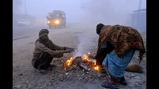
Dense fog disrupts visibility across north India
Dense to very dense fog severely reduced visibility at several locations in Punjab, Uttar Pradesh and Odisha, with visibility dropping below 50 metres in places such as Amritsar, Prayagraj and Kanpur, the IMD said.
Fog conditions were also reported from parts of Haryana, Bihar, Madhya Pradesh and Meghalaya.
The IMD has issued a dense fog warning for Punjab, Haryana and Chandigarh till February 3, with isolated foggy conditions likely to persist till February 5.
Similar fog alerts remain in place for western Uttar Pradesh, Rajasthan, Bihar, Assam, Meghalaya, Odisha and Sub-Himalayan West Bengal over the next few days.
Temperatures to dip, Delhi NCR to see partly cloudy day
Minimum temperatures across northwest India are expected to fall by 2-4 degrees Celsius over the next three days.
Delhi NCR is likely to experience shallow to moderate fog during morning hours from February 2 to 4, with maximum temperatures remaining below normal.
Read more: Budget 2026 sparks political debate over growth, investment, and fiscal strategy
The IMD forecast suggests partly cloudy skies over Delhi, with minimum temperatures ranging between 8-12 degrees Celsius and light northerly to north-westerly winds prevailing during the period.
The weather agency advised residents, particularly in fog-prone regions, to remain cautious during early morning and night hours due to reduced visibility and colder conditions.
The IMD said the weather activity is being driven by successive western disturbances, with another system expected to affect northwest India from February 5, bringing renewed precipitation and colder conditions.
Western disturbances to bring more rain and snow
Light to moderate rain and snowfall occurred at many locations across Jammu and Kashmir, Ladakh and Himachal Pradesh, with isolated rainfall reported in Haryana, western Uttar Pradesh and east Rajasthan, as per IMD.
Thunderstorms accompanied by squally winds of 30-50 kmph were also observed over Uttarakhand during the past day.
The weather agency stated that scattered to fairly widespread rain and snowfall, along with thunderstorms, lightning and gusty winds, are likely to continue over Jammu and Kashmir, Himachal Pradesh and Uttarakhand till February 3.
Read more: Amrit Udyan to open for public viewing from Feb 3: How to book tickets, timings, important dates
Another western disturbance is expected to impact the western Himalayan region between February 5 and 7, extending fresh precipitation over the hills, the IMD added.
Dense fog disrupts visibility across north India
Dense to very dense fog severely reduced visibility at several locations in Punjab, Uttar Pradesh and Odisha, with visibility dropping below 50 metres in places such as Amritsar, Prayagraj and Kanpur, the IMD said.
Fog conditions were also reported from parts of Haryana, Bihar, Madhya Pradesh and Meghalaya.
The IMD has issued a dense fog warning for Punjab, Haryana and Chandigarh till February 3, with isolated foggy conditions likely to persist till February 5.
Similar fog alerts remain in place for western Uttar Pradesh, Rajasthan, Bihar, Assam, Meghalaya, Odisha and Sub-Himalayan West Bengal over the next few days.
Temperatures to dip, Delhi NCR to see partly cloudy day
Minimum temperatures across northwest India are expected to fall by 2-4 degrees Celsius over the next three days.
Delhi NCR is likely to experience shallow to moderate fog during morning hours from February 2 to 4, with maximum temperatures remaining below normal.
Read more: Budget 2026 sparks political debate over growth, investment, and fiscal strategy
The IMD forecast suggests partly cloudy skies over Delhi, with minimum temperatures ranging between 8-12 degrees Celsius and light northerly to north-westerly winds prevailing during the period.
The weather agency advised residents, particularly in fog-prone regions, to remain cautious during early morning and night hours due to reduced visibility and colder conditions.