


What's Happening?
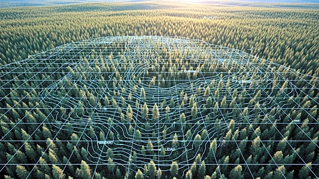
Max Resource Corp. has announced the commencement of an airborne high-resolution LiDAR survey over the Mora mining concession located in the Middle Cauca Gold Belt, Colombia. This survey aims to delineate high-priority drill locations and identify new targets within the concession. The Mora property, which Max Resource has the exclusive right to purchase, is situated 85 kilometers south of Medellin and hosts several world-class gold deposits. The LiDAR technology will assist in building a 3D model of the terrain, crucial for the success of Max's planned drill program. The survey is part of Max's broader exploration strategy, which includes geological and geophysical data collection, channel sampling of artisanal mines, and 3D modeling. The company
has mapped nine inactive mines and aims to uncover hidden artisanal mines through the LiDAR survey.
Why It's Important?
The initiation of the LiDAR survey by Max Resource Corp. is a significant step in advancing the exploration of the Mora property, potentially leading to the discovery of new gold deposits. The Middle Cauca Gold Belt is known for its rich mineral resources, and successful identification of drill targets could enhance Max's position in the mining industry. The use of LiDAR technology represents a modern approach to exploration, offering precise geospatial data that can reduce the risks associated with traditional methods. This development could attract further investment and interest in the region, potentially boosting local economies and contributing to the global gold supply.
What's Next?
Following the LiDAR survey, Max Resource Corp. plans to proceed with drilling activities based on the identified targets. The company will continue its exploration program, which includes detailed geological and geophysical analysis. Stakeholders, including investors and local communities, will be closely monitoring the outcomes of these activities. The success of the survey and subsequent drilling could lead to increased exploration and mining activities in the Middle Cauca Gold Belt, potentially impacting regional development and employment.
Beyond the Headlines
The use of LiDAR technology in mining exploration highlights the industry's shift towards more sustainable and efficient practices. By providing detailed terrain models, LiDAR reduces the environmental impact of exploration activities, as it minimizes the need for extensive ground disturbance. This approach aligns with global trends towards responsible mining and could set a precedent for other companies in the sector. Additionally, the integration of advanced technologies in mining could lead to innovations in other areas, such as resource management and environmental conservation.