


Saguaro National Park, located in southeastern Arizona, is a fascinating area that showcases the diverse landscapes of the Sonoran Desert. Established as a national park in 1994, it is divided into two distinct districts: the Tucson Mountain District and the Rincon Mountain District. Each district offers unique geological features and ecosystems, making the park a rich tapestry of natural beauty and biodiversity.
The Tucson Mountain District
The Tucson Mountain District (TMD)
is situated about 10 miles west of Tucson. This area is characterized by its volcanic rock formations, which differ significantly from those found in the Rincon Mountain District. Over the past 30 million years, geological processes have shaped the landscape, resulting in the displacement of rocks from beneath the Tucson Mountains to form the Rincon Mountains. The Tucson Mountains are lower in elevation compared to the Rincons, with elevations ranging from 2,180 to 4,687 feet, culminating at Wasson Peak.
The TMD is known for its desert scrub and grassland communities, which thrive in the arid conditions. The volcanic history of the area is evident in the large breccia and granitic remnants visible in the district. These geological features not only define the landscape but also contribute to the area's unique biodiversity.
The Rincon Mountain District
In contrast, the Rincon Mountain District (RMD) lies about 10 miles east of Tucson and is significantly higher and wetter than the TMD. The Rincon Mountains, part of the Madrean Sky Islands, support a wide range of plant and animal life not found in the Tucson Mountain District. Elevations in the RMD range from 2,670 to 8,666 feet, with Mica Mountain being the highest point.
The RMD's diverse ecosystems include oak woodland, pine-oak woodland, and mixed conifer forests at higher elevations. This variety of habitats supports a rich array of flora and fauna, making it a vital area for biodiversity. The Rincon Creek, located in the southern part of the district, features the largest riparian zone in the park, providing a crucial water source for the area's wildlife.
The Sonoran Desert Landscape
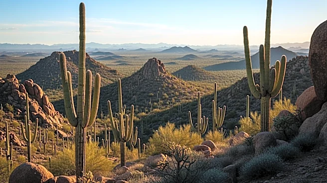
Both districts of Saguaro National Park are part of the Sonoran Desert, known for its iconic saguaro cacti. These towering cacti are a symbol of the American Southwest and thrive in the park's desert environment. The park's location within the watershed of the Santa Cruz River, which is generally dry, adds to the unique desert landscape.
The park's geography is further defined by its proximity to the Tucson Basin and nearby mountain ranges, including the Santa Catalinas and the Rincons. These features are part of the Basin and Range Province, a region formed by the stretching and thinning of the Earth's crust. This geological history has created a landscape of dramatic contrasts, from the rugged mountains to the expansive desert valleys.
Saguaro National Park's geography is a testament to the dynamic forces of nature that have shaped the land over millions of years. Its diverse landscapes offer visitors a chance to explore the beauty and complexity of the Sonoran Desert, making it a unique and valuable natural treasure.