


Tennessee, a state in the southeastern United States, is renowned for its diverse geography and natural beauty. From the towering peaks of the Blue Ridge Mountains to the fertile plains of West Tennessee, the state's landscape is as varied as it is stunning. This article delves into the geographical features that define Tennessee, highlighting the unique characteristics of its three Grand Divisions: East, Middle, and West Tennessee.
East Tennessee: The Appalachian Mountains
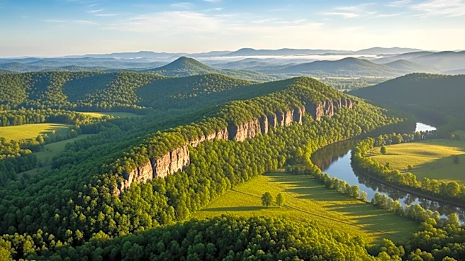
East Tennessee
is dominated by the Appalachian Mountains, which include the Blue Ridge Mountains and the Great Smoky Mountains. These ranges are home to some of the highest elevations in eastern North America, with peaks averaging around 5,000 feet. The region's rugged terrain is characterized by steep ridges and deep valleys, offering breathtaking vistas and a haven for outdoor enthusiasts. The Great Smoky Mountains National Park, the most visited national park in the United States, is located here, drawing millions of visitors each year to its scenic beauty and diverse wildlife.
The Ridge-and-Valley Appalachians, also known as the Tennessee Valley, stretch westward from the Blue Ridge Mountains. This area consists of linear ridges and valleys that run northeast to southwest, creating a distinctive landscape. The Tennessee River, a major waterway, flows through this region, providing vital resources and recreational opportunities.
Middle Tennessee: The Highland Rim and Nashville Basin
Middle Tennessee is characterized by the Highland Rim and the Nashville Basin, part of the Interior Low Plateaus. The Highland Rim is an elevated plain that surrounds the Nashville Basin, a geological dome known for its rich, fertile farmland. This area is marked by rolling hills and karst topography, with numerous caves, sinkholes, and underground streams.
The Nashville Basin is particularly notable for its agricultural productivity, thanks to its fertile soils. This region is also home to the state's capital, Nashville, which sits at the heart of the basin. The combination of natural beauty and economic vitality makes Middle Tennessee a significant cultural and economic hub.
West Tennessee: The Mississippi Alluvial Plain
West Tennessee is defined by the Mississippi Alluvial Plain, a flat, fertile region that extends from the Gulf of Mexico to southern Illinois. This area is characterized by lowlands, floodplains, and swamps, shaped by the meandering Mississippi River. The river forms the western boundary of the state, providing a vital transportation route and supporting a rich ecosystem.
The fertile soils of West Tennessee make it an important agricultural region, with crops like cotton and soybeans thriving in the area. The region's flat terrain contrasts sharply with the mountainous landscapes of East Tennessee, highlighting the state's geographical diversity.