


The United States Virgin Islands are a captivating group of islands located in the Caribbean Sea. Known for their stunning landscapes and strategic location, these islands offer a unique blend of natural beauty and geographic significance. Situated about 1,100 miles southeast of Florida and 40 miles east of Puerto Rico, the U.S. Virgin Islands are part of the Virgin Islands archipelago, which includes the British Virgin Islands, Vieques, and Culebra.
This article delves into the geographic features that define the U.S. Virgin Islands.
Location and Surroundings
The U.S. Virgin Islands are positioned near the boundary of the North American Plate and the Caribbean Plate, making them geologically significant. They lie roughly 100 miles south of the Puerto Rico Trench, a notable underwater feature. The islands are surrounded by the North Atlantic Ocean to the north and the Caribbean Sea to the south, providing them with a diverse marine environment. This strategic location has historically made the islands a key shipping lane, particularly near the Anegada Passage.
The islands are part of the Virgin Islands archipelago, which is geologically separated from the Lesser Antilles by the Anegada Passage and from the Greater Antilles by the Mona Passage. This separation contributes to the unique geological characteristics of the islands, with Saint Croix being the exception as it lies on a different carbonate platform.
Island Features and Terrain
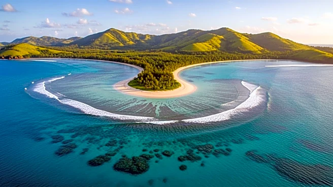
The U.S. Virgin Islands consist of several dozen islands and cays, with Saint Thomas, Saint John, and Saint Croix being the main islands. Saint Thomas and Saint John are hilly and volcanic, bordered by the North Atlantic Ocean and the Caribbean Sea. Saint Croix, the largest island, is entirely in the Caribbean Sea and lies 40 miles south across the Virgin Islands Trough.
The terrain of the islands is mostly hilly to rugged and mountainous, with little level land. Crown Mountain on Saint Thomas is the highest point at 1,555 feet. The islands boast a coastline of 117 miles, known for its beautiful beaches and coral reefs. Notable natural landmarks include Magens Bay on Saint Thomas and Trunk Bay on Saint John, as well as the Virgin Islands Coral Reef National Monument.
Climate and Natural Hazards
The U.S. Virgin Islands enjoy a tropical climate moderated by easterly trade winds, with relatively low humidity. Temperatures vary little throughout the year, with summer highs around 91°F and winter highs around 86°F. Rainfall averages about 38 inches per year, with September to November being the wettest months.
The islands are prone to tropical storms and hurricanes, with a hurricane season from June to November. Recent history has seen significant damage from hurricanes such as Irma and Maria in 2017. Despite these challenges, the islands remain a popular destination for their natural beauty and favorable climate.