


For Rolling Fog: The Oregon Coast
There are few sights as mystical as a thick marine layer rolling in from the Pacific to swallow the coastline. The Oregon coast, particularly the stretch between Cannon Beach and Samuel H. Boardman State Scenic Corridor, is a masterclass in atmospheric
drama. This isn't your average gloomy day; it's an active, moving spectacle. The fog, born from the collision of cool ocean air and warmer land, doesn't just sit there. It creeps through ancient Sitka spruce forests, wraps around iconic sea stacks like Haystack Rock, and creates a sense of ethereal mystery. For the best experience, find a high vantage point like Neahkahnie Mountain or a cozy cliffside cabin. You can spend a morning watching the world disappear and reappear, a breathtaking show that’s both peaceful and powerful. The best viewing times are often late spring and early fall, when the temperature differences are most pronounced.
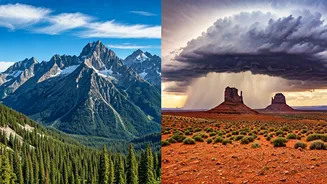
For Alien Invasions: The Eastern Sierra, California
If you want to see clouds that look like they belong on another planet, head to the Eastern Sierra. This is the land of the lenticular cloud—smooth, stationary, saucer-shaped formations that seem to hover silently over mountain peaks. They look so much like UFOs that they're a common source of sighting reports. These clouds form when stable, moist air flows over a massive barrier, like the Sierra Nevada range, creating standing waves in the atmosphere. The clouds materialize at the crest of these waves. The Owens Valley, with its stark desert floor and the towering wall of the Sierras, provides the perfect theater. Drive Highway 395 between Lone Pine and Bishop on a windy day, and you're almost guaranteed to see these silent, sculptural wonders stacked in the sky. It's a photographer’s dream and a humbling reminder of the invisible forces shaping our world.
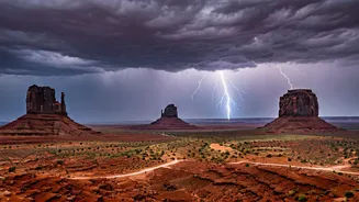
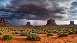
For Towering Power: The Great Plains
This one comes with a serious caveat: do it safely, preferably with a guided tour. But for the most awesome display of meteorological power on the continent, nothing beats the anvil-headed thunderheads of the Great Plains. In late spring, from the Texas Panhandle up through Oklahoma and Kansas—the heart of "Tornado Alley"—the sky can transform from placid blue to a churning cauldron in a matter of hours. The sheer scale is difficult to comprehend. Supercell thunderstorms build vertically into the stratosphere, their tops spreading out in the iconic anvil shape. Watching one of these systems gather strength from a safe distance is a primal experience, a direct view of nature’s raw creative and destructive energy. Professional storm-chasing tours handle the logistics and complex forecasting, putting you in the right place at the right time without the risk, allowing you to just witness the sublime spectacle.
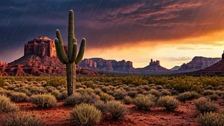
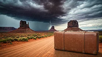
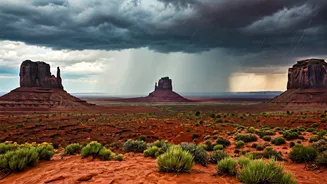
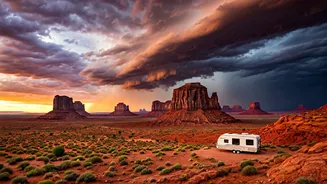
For Monsoon Drama: The Desert Southwest
Summer in Arizona and New Mexico means monsoon season. From July to early September, the typically bone-dry desert landscape comes alive with some of the most dramatic skies in the country. The day starts clear and hot, but by early afternoon, colossal cumulonimbus clouds begin to build over the mountains. They rise like brilliant white castles before their bases turn a bruised purple, promising a deluge. The ensuing storms are brief but violent, with crackling lightning and curtains of rain that you can see approaching from miles away. When the storm passes, it leaves behind air scrubbed clean, the smell of rain-soaked creosote, and often, a double rainbow against the red rock. Head to places like Sedona, Arizona, or the high desert around Santa Fe, New Mexico, find a spot with a panoramic view, and watch the daily drama unfold. It’s a full-sensory performance, from the rumbling thunder to the incredible light.