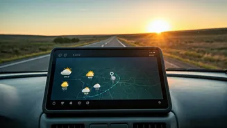


Why Your Weather App Is Often Wrong
To understand why this new AI approach is such a big deal, you first have to know how we’ve been forecasting weather for decades. The traditional method, called Numerical Weather Prediction (NWP), is a marvel of science. It uses some of the world’s most
powerful supercomputers to solve hideously complex physics equations that model the Earth's atmosphere. Think of it as a massive, digital simulation of the planet, taking current conditions—temperature, pressure, wind—and calculating forward in time to see what happens next. The gold standard has long been the European Centre for Medium-Range Weather Forecasts (ECMWF) model, a system so computationally intensive it takes hours to run. The problem? The atmosphere is chaotic. Tiny errors in the initial data can snowball into huge forecast mistakes a week later. This is why a 10-day forecast for your beach trip can feel more like a suggestion than a certainty.
How Artificial Intelligence Changes the Game
Instead of solving physics from scratch, AI models take a completely different route. Tech giants like Google and NVIDIA have trained AI systems on decades of historical weather data. Google’s model, named GraphCast, hasn't been taught fluid dynamics; it's been shown the weather map from virtually every day for the last 40 years and what happened next. By analyzing these hundreds of thousands of examples, the AI learns the patterns. It's less like a physicist with a calculator and more like a seasoned sailor who has seen every kind of sky and can tell you what storm follows. It recognizes relationships and outcomes that are too complex or subtle for traditional models to capture perfectly. It doesn't need to simulate the physics because it has already seen the results of those physics in action, over and over again.
Faster, Sharper, and Further Out
The results of this new approach are stunning. Where the best traditional models need hours of supercomputer time to generate a 10-day forecast, Google’s GraphCast can do it on a single specialized computer in under a minute. It’s not just faster; it’s more accurate. In tests comparing it to the ECMWF’s high-resolution system, GraphCast provided a more accurate forecast on over 90% of variables. Crucially, its biggest advantage is in the medium-range forecast—the 3-to-10-day window that is vital for planning things like a holiday weekend. Furthermore, these AI models have shown an uncanny ability to predict extreme weather events, like the path of a hurricane or the location of an atmospheric river, with greater lead time and precision. This leap in performance is being hailed as one of the biggest advances in meteorology in a generation.
So, What Does This Mean for Your Road Trip?
You probably won't be downloading a 'GraphCast' app tomorrow. This technology is, for now, a tool for the experts. National weather agencies like the National Oceanic and Atmospheric Administration (NOAA) are already exploring how to integrate these AI models into their official forecasting workflows. Think of it as giving your trusted local meteorologist a new superpower. When they tell you that Saturday looks clear for your drive to the mountains but rain is moving in Sunday afternoon, that forecast will be backed by a new level of data-driven confidence. The practical benefit for you is reliability. The chances of a surprise washout are dropping. You can make go/no-go decisions on plans with more certainty, whether it’s booking a non-refundable cabin, planning a big family BBQ, or just deciding which day is best for a long drive.