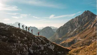


Tour du Mont Blanc
Circumnavigate the majestic Mont Blanc massif on this legendary 106-mile route, spanning France, Italy, and Switzerland. While elite ultrarunners tackle
it in a single race, ordinary runners can savor the experience over multiple days, staying in charming mountain refuges. For a taste of its grandeur, consider the 28-mile segment between Courmayeur, Italy, and Champex Lac, Switzerland. Regardless of the distance covered, the journey offers unparalleled alpine vistas and delectable European cuisine, making it a truly immersive experience in the heart of the Alps.
Presidential Traverse
Traverse the rugged spine of New Hampshire's White Mountains on the 18-mile Presidential Traverse, summiting nine peaks named after U.S. presidents. This point-to-point route, primarily on the steep and rocky Appalachian Trail, is deceptively challenging despite its moderate distance. Runners will encounter dramatic elevation changes and exposure above the treeline, demanding respect for the notoriously unpredictable White Mountain weather. Essential resupply points include two Appalachian Mountain Club huts and several river crossings. This iconic trail is also a popular venue for those seeking to set Fastest Known Times (FKTs).
Kalalau Trail
For those with exceptional agility and a thirst for dramatic coastal scenery, the 22-mile Kalalau Trail on Kauai, Hawaii, is an extraordinary out-and-back adventure. Portions of the path wind precariously along steep cliffs that plunge directly into the Pacific Ocean, and frequent rainfall can transform the red dirt and lava rock into a slick, challenging surface. The reward for navigating these demanding conditions is a spectacular panorama of lush green vegetation meeting the deep blue sea. An overnight camping permit is required to explore beyond the initial two miles to Hanakāpī’ai Valley, underscoring the trail's remote and wild nature. Access requires advance parking reservations or a shuttle from Hanalei Bay.
Timberline Trail
Experience a complete circuit of Oregon's iconic Mount Hood on the 41.5-mile Timberline Trail. This loop offers a diverse running experience, guiding you through dense forests, across dynamic river crossings, and past ancient glaciers on the flanks of the 11,249-foot dormant volcano. Most runners begin and end their journey at the historic Timberline Lodge. The trail alternates between alpine meadows and subalpine forests, providing a constantly shifting landscape. Established campgrounds with basic amenities are available, and water can be refilled at specific points. Permits are necessary but readily available at trailheads without a numerical restriction.
Four Pass Loop
Discover the breathtaking beauty of the Colorado Rockies on the 27-mile Four Pass Loop, located just outside Aspen. This challenging route navigates four distinct alpine passes, each soaring above 12,400 feet, with the highest point reaching 12,500 feet at West Maroon Pass. For runners unaccustomed to high altitudes, this loop presents a significant test of physical and mental fortitude. The scenery is a vibrant tapestry of summer wildflowers, snow-dusted peaks, golden aspen groves, and serene alpine lakes, all within the stunning Maroon Bells-Snowmass Wilderness. Runners are urged to tread lightly and adhere to Leave No Trace principles, respecting the delicate alpine environment. A parking pass is required for day access to the trailhead.
Milford Track
Embark on a remote and spectacular journey along New Zealand's South Island on the 33-mile Milford Track. This route, situated within the dramatic Fjordland National Park, necessitates water taxi transport at both its beginning and end, adding an element of adventure to the expedition. Along the track, operated by New Zealand's Department of Conservation, hikers can find overnight accommodations in designated huts, with some private lodges and shelters also available. The trail itself is a raw and stunning passage through unique fjord and mountain terrain, featuring numerous bridges, including the notable 236-foot-long Clinton River Bridge.
Grand Canyon R2R2R
Face one of the most demanding and visually stunning challenges in trail running with the Grand Canyon Rim-to-Rim-to-Rim (R2R2R) route. This epic undertaking begins on the South Rim, descends to the mighty Colorado River, ascends to the North Rim, and then retraces its path back to the South Rim. The full circuit involves approximately 22,000 feet of combined elevation gain and loss, spanning between 42 and 48 miles, depending on specific trail choices. Optimal conditions are found in spring and fall. Comprehensive preparation is paramount, including ample hydration, nutrition, and appropriate gear, as water sources can be inconsistent. Runners must also share the trails respectfully with other users, particularly in the heavily trafficked areas below the South Rim. Note: A section of the North Kaibab Trail is currently closed, impacting the full route's accessibility.