


India's Lyari Explained
The term 'Lyari' in India has recently surged in online popularity, sparking curiosity and some confusion due to its namesake in Pakistan. However, the
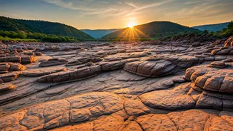
Indian Lyari refers to a remarkable seasonal riverbed situated within the arid Rann of Kutch in Gujarat. This natural feature isn't a constant watercourse; it flourishes primarily during the monsoon season. As the rains recede, the river gradually dries up, revealing a vast expanse of dry riverbed punctuated by intermittent water pools. This captivating dry landscape is the core attraction, drawing attention for its unique geological characteristics and scientific value, entirely distinct from any urban or border-related narratives.
No Pakistani Link
It's crucial to clarify that the 'Lyari' currently making waves online in India has absolutely no connection to the Lyari River in Karachi, Pakistan, nor is it an urban settlement. This Indian Lyari is a purely natural geological formation, an integral part of Gujarat's diverse topography. The name similarity has led to widespread misconceptions, but the reality is that this Lyari possesses its own distinct identity and significance, rooted solely in its natural landscape and ecological context within India.
Captivating Landscape Features
The allure of Gujarat's Lyari lies predominantly in its extraordinary riverbed structure. Over eons, the relentless interplay of water flow, wind, and geological time has sculpted intricate layers of rock. These formations exhibit a textured, carved appearance, offering a visually striking testament to nature's artistry. The land's unique patterns and contours are a direct result of these powerful natural forces, creating a landscape that is both ancient and mesmerizing. This detailed layering provides valuable insights into the region's environmental history, making it a site of significant geological interest.
Location and Access
The Lyari riverbed is strategically located approximately 70 kilometers from Bhuj, a prominent city in Gujarat, and is situated in close proximity to the significant Dhinodhar Hills. While it is beginning to attract visitors interested in its unique natural beauty, Lyari remains a relatively undiscovered gem. It has not yet attained the status of a major tourist destination, preserving its serene and untouched atmosphere. Its accessibility makes it a feasible excursion for those exploring the Kutch region, offering a glimpse into a less-traveled natural wonder.
Geological Significance
Beyond its aesthetic appeal, the rock formations found within Lyari hold considerable scientific importance. These stratified rocks are considered invaluable archives, potentially containing information about the region's past climatic conditions and environmental changes. Paleoclimatologists and geologists can study these layers to reconstruct historical weather patterns, providing crucial data for understanding long-term climate shifts. This makes Lyari more than just a beautiful landscape; it's a natural laboratory offering profound insights into Earth's history.
Dhinodhar Hill's Role
The nearby Dhinodhar Hill adds another layer of geological intrigue to the Lyari region. Identified as a volcanic plug, this remarkable structure formed when molten lava cooled and solidified within a volcanic conduit. Over vast stretches of time, the softer surrounding rock eroded away, leaving this resistant igneous formation standing prominently. The natural drainage patterns emanating from Dhinodhar Hill radiate outwards, significantly influencing the overall landscape and contributing to the distinct topographical layout of the area surrounding Lyari.
Seasonal Transformation
Lyari exhibits a dynamic seasonal transformation, offering different experiences throughout the year. During the monsoon, it functions as a flowing river, its waters carving through the landscape. However, as the monsoon season concludes, the water recedes, leaving behind a tranquil, arid riverbed dotted with ephemeral pools. The visual appeal of Lyari is often amplified during the early morning and late evening hours. At these times, the changing light casts dramatic shadows and highlights the rich earthy tones of the terrain, creating breathtaking panoramic views that captivate visitors.
Regional Development Impact
While Lyari itself has largely retained its natural state, the surrounding region is experiencing a gradual shift due to developmental activities. Areas adjacent to the riverbed, such as the Banni Grassland, are witnessing the implementation of various projects. These include mining operations and the establishment of renewable energy infrastructure, notably solar and wind power installations. These initiatives, while contributing to regional progress, are subtly altering the broader landscape around the historically significant Lyari riverbed, presenting a dynamic interplay between nature and human development.