


The Illusion Unveiled
The natural world often presents us with scenes that seem to defy the laws of physics, tricking our eyes and sparking our curiosity. Among these marvels
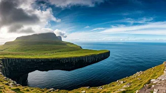
is Sørvágsvatn, a spectacular lake located in the Faroe Islands, renowned for an optical illusion that makes it appear to be perched dramatically above the vast expanse of the Atlantic Ocean. This perception has garnered significant international attention, captivating visitors and photographers alike. While the visual spectacle is undeniably real, the scientific explanation behind this captivating phenomenon is equally intriguing, rooted in the island's unique geological features and geographical positioning. Photographs often amplify this effect, making the lake seem to hover hundreds of meters above the sea, when in reality, the elevation difference is a more modest 30 to 40 meters, a testament to how perspective can reshape our understanding of a landscape.
Largest Lake's Identity
Beyond its famous visual trick, Sørvágsvatn holds the distinction of being the largest body of freshwater in the entire Faroe Islands archipelago. It is situated on Vágar Island, an area conveniently close to the islands' sole airport, making it an accessible yet still somewhat remote destination. Locally, and particularly among residents of nearby communities, the lake is also recognized by the name Leitisvatn. Its water supply originates from a network of smaller streams and the abundant rainfall characteristic of the region. This water eventually finds its way to the Atlantic Ocean, dramatically cascading over a cliff face in a breathtaking waterfall known as Bosdalafossur, an event that further enhances the lake's mystique while maintaining its freshwater status.
Geological Foundations
The dramatic landscapes of the Faroe Islands owe their existence to volcanic activity, with ancient lava flows of basalt forming the very bedrock of the region. Sørvágsvatn is nestled within this rugged, geologically rich terrain, sculpted by a complex interplay of natural forces over millennia. The imposing cliffs that cradle the lake and the rugged coastline bordering the islands are not merely aesthetic features; they are fundamental to the creation of the island's striking topography. Crucially, these geographical elements are also the architects of the famous illusion. The lake's placement, slightly inland and adjacent to ocean-facing cliffs, is what orchestrates this visual deception. From elevated vantage points, particularly from the Trælanípa cliffs, the absence of immediate visual cues for the space between the lake and the ocean allows the illusion of a suspended body of water to take hold.
Photographer's Haven
In recent years, Sørvágsvatn has ascended to prominence as a favored destination for both seasoned photographers and intrepid travelers seeking landscapes that offer a departure from the ordinary. The journey to Trælanípa, a cliff renowned for its commanding views, is particularly sought after, as it is from this vantage point that the most compelling illusion of the lake floating in mid-air is achieved. Despite its growing popularity, the site has managed to retain a sense of untouched natural beauty, avoiding the extensive commercialization often seen in more mainstream tourist spots. Visitors are encouraged to tread lightly and stick to designated trails, given the challenging, uneven terrain and the region's notoriously unpredictable weather patterns. It's important to remember that the lake doesn't truly float; it sits at a significant elevation, with the perceived levitation being a masterful play of geography and perspective, making Sørvágsvatn a unique treasure from both visual and scientific standpoints.