


Field Access Revolution
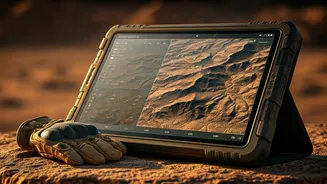
The U.S. Special Operations Command is actively evaluating a cutting-edge mobile software platform designed to grant operators in remote or contested areas
immediate access to commercial satellite imagery and sophisticated analytics. This innovative system is engineered to function directly on ruggedized Android tactical devices, commonly known as ATAK (Android Tactical Assault Kit) devices. These robust smartphones and tablets are indispensable tools for military and law enforcement, facilitating comprehensive battlefield awareness, precise mapping, and seamless mission coordination. The surge in commercial Earth-observation satellite capabilities is fundamentally altering how intelligence is consumed by military units. Rather than relying exclusively on intelligence filtered and disseminated through traditional, centralized analysis hubs, modern operators increasingly demand the ability to access raw satellite data and derived insights directly on their mobile equipment while actively engaged in missions, especially when connectivity is compromised or limited. This shift empowers forces operating at the 'tactical edge' with more timely and relevant information for critical decision-making.
SkyFi's Tactical Edge
Developed by SkyFi, a geospatial data firm based in Austin, this software solution is specifically tailored to meet the needs of military personnel who require enhanced access to imagery and AI-driven analytics in dispersed or communication-challenged operational zones. SkyFi's chief executive, a former U.S. special operations aviator, highlighted the growing demand for such capabilities. The company secured a contract, the value of which remains undisclosed, to develop this specialized software along with an ATAK plugin, and to conduct initial field assessments with SOCOM operators. An extensive network of defense contractors and software developers has sprung up around the ATAK platform, creating various plugins and data services that significantly expand its utility. Users can consolidate diverse information streams—including maps, real-time friendly force locations, drone feeds, sensor readings, and operational data—into a single, unified mobile interface. SkyFi aims to seamlessly integrate commercial satellite imagery into this existing operational ecosystem, providing a critical layer of intelligence directly at the user's fingertips, enhancing situational awareness and operational effectiveness in dynamic environments.
Earth Intelligence Marketplace
SkyFi operates a unique Earth intelligence marketplace, aggregating a vast array of imagery and analytical products from numerous commercial imaging constellations, rather than owning satellites itself. This platform consolidates diverse data types, including high-resolution optical imagery, synthetic aperture radar (SAR), and hyperspectral data, sourced from multiple providers. The current landscape of commercial satellite technology generates an unprecedented volume of imagery, coupled with advancements in cloud computing and mobile software, fostering an expectation that intelligence products should be readily available to field operators. Without direct access, military personnel previously had to submit requests through formal, centralized channels well in advance of operations, with limited ability to retrieve or task imagery once deployed, particularly in areas with denied or degraded communications. SkyFi's software allows users to retrieve archived imagery, initiate requests for new image captures, and integrate remote sensing data directly into their mission workflows. While some advanced functions, like direct satellite tasking, still require cloud connectivity, the core benefit lies in providing actionable intelligence at the point of need.
Optimizing Data Delivery
A key challenge addressed by this platform is bandwidth management. Instead of transmitting massive quantities of raw imagery to deployed forces, the strategic approach is to deliver highly focused, localized datasets tailored to a user's specific area of operation. For instance, if forces are operating in a particular country, the system prioritizes imagery relevant to that immediate theater, rather than the entire nation. The company has already conducted extensive testing of similar direct-to-device imagery systems with international military units over the past year, validating its effectiveness. Furthermore, the potential applications extend beyond military contexts. SkyFi is actively promoting comparable capabilities to civilian agencies and emergency response organizations that already utilize ATAK devices, such as law enforcement, firefighting, and forestry services. The widespread adoption of ATAK devices, numbering over 500,000 users across these sectors, underscores the broad applicability of this technology. The development of the SkyFi application was significantly influenced by former engineers from Uber, emphasizing a collective drive to deliver critical information efficiently to the front lines of operation.