


Rainfall's Role
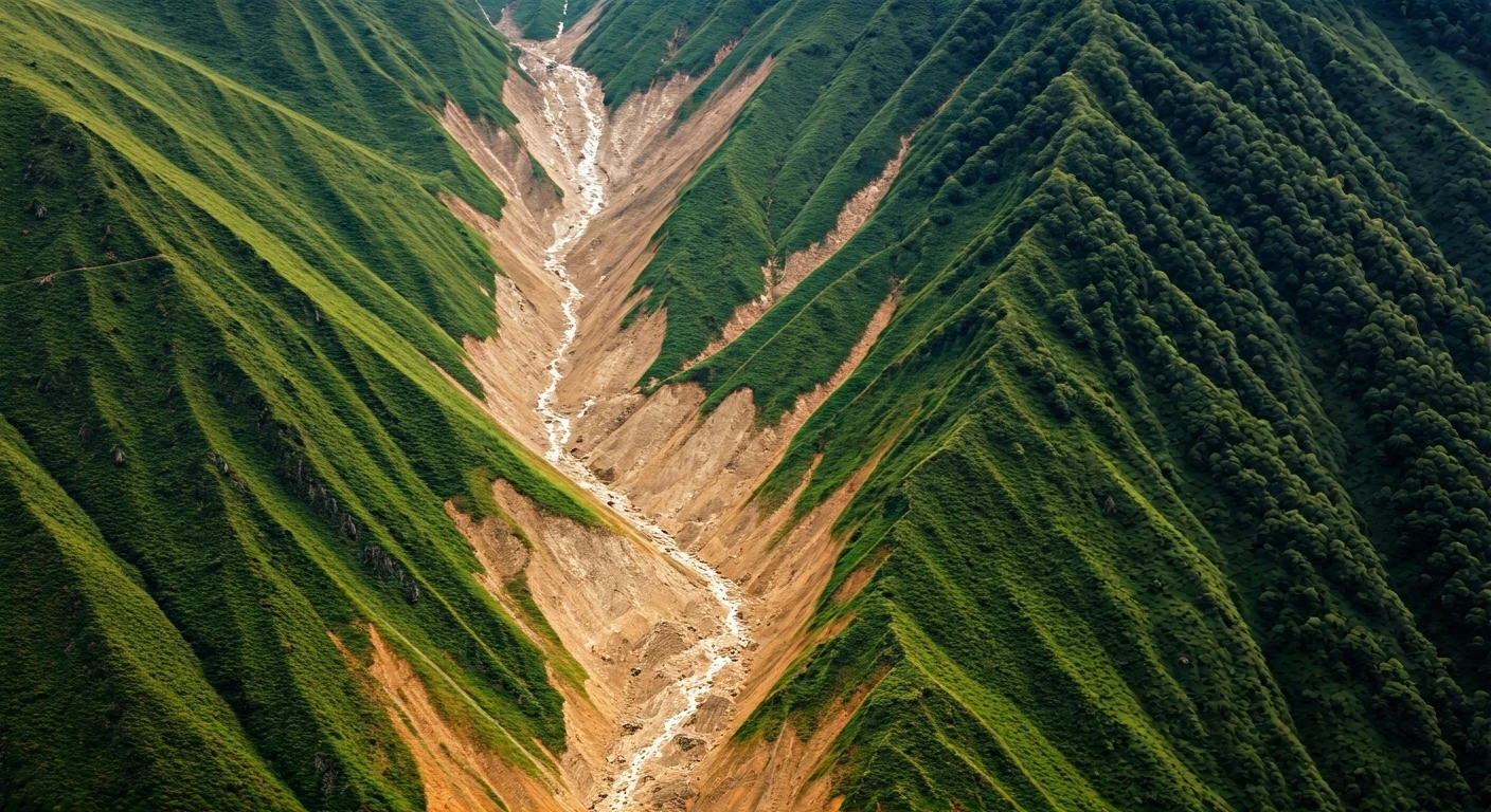
The primary trigger for the Darjeeling landslides was the unusually heavy rainfall experienced in October. The slopes in the Himalayas, already vulnerable,
became saturated with water. This saturation significantly reduced the stability of the soil and rock formations. The GSI has specifically pointed out the excessive rainfall as the immediate cause. The impact of the rainfall was amplified by the pre-existing geological conditions of the region, which made it prone to such disasters. Understanding the intensity and duration of the rainfall is crucial to fully comprehend the scope of the landslides and their impact on the landscape and communities.
Saturated Slopes Unveiled
The Himalayan slopes, already known for their susceptibility to landslides, became extremely vulnerable because of the excessive water saturation. This saturation essentially acted as a lubricant, diminishing the cohesive forces within the soil and rock layers. This, in turn, made the slopes more prone to collapse. The GSI's assessment highlights that the geological structure combined with the prolonged exposure to heavy rainfall was a lethal combination. The saturated conditions increased the pore water pressure, leading to a reduction in the shear strength of the soil, thereby causing the devastating landslides observed in Darjeeling. This underscores the critical role of water management and risk assessment in such high-risk regions.
Geological Considerations
The underlying geological characteristics of the Darjeeling region are also significant in understanding the cause of the landslides. The area is characterized by complex geological formations, including the presence of unstable rock formations and steep slopes. These factors, combined with intense rainfall, created ideal conditions for landslides to occur. The Himalayan region is geologically young and still undergoing significant tectonic activity, making it inherently unstable. The GSI’s findings highlight the need for ongoing geological surveys and risk assessments to identify vulnerable areas and implement mitigation strategies. This includes developing early warning systems and enforcing stricter regulations regarding construction and land use in high-risk zones.
Consequences and Impacts
The landslides had a significant impact on the Darjeeling region, causing damage to infrastructure, loss of life, and disruption to daily life. Roads, bridges, and buildings were destroyed or damaged, leading to isolation and hardship for residents. The displacement of people and the loss of property created enormous challenges for the local authorities, including emergency response and long-term rehabilitation efforts. Furthermore, landslides have long-term environmental consequences, affecting soil erosion, water quality, and biodiversity. Assessing the extent of these impacts is necessary for planning recovery efforts and formulating strategies to build resilience and mitigate the risk of future disasters. Recovery efforts may involve relocating communities, implementing infrastructure improvements, and reforesting affected areas.
GSI's Analysis Findings
The GSI played a crucial role in assessing the causes of the landslides in Darjeeling. Through their investigation, they gathered critical data about rainfall intensity, soil conditions, and geological factors. Their detailed analysis confirmed the direct link between heavy October rainfall and the resulting landslides. The GSI’s work also offers valuable insights for predicting future landslides and implementing effective preventative measures. The findings from the GSI investigation will be essential in developing disaster management plans, improving early warning systems, and enhancing the resilience of communities at high risk. These scientific efforts help policymakers make informed decisions and reduce the impact of natural disasters.