


A Name, Not A City
A curious keyword, 'Lyari in India,' has been circulating across social media and search engines, sparking immediate confusion due to its similarity to a well-known
area in Karachi, Pakistan. However, this trending term doesn't refer to a bustling urban center or a geopolitical story. Instead, it highlights a spectacular natural phenomenon in Gujarat: a seasonal riverbed within the vast Rann of Kutch. This geological marvel has been present for years, appreciated by locals, but is now capturing broader attention for its unique arid landscape and scientific significance. It's a testament to nature's artistry, an overlooked treasure finally stepping into the spotlight.
Gujarat's Dry Riverbed
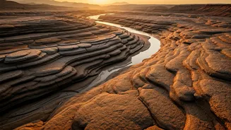
In the Indian context, 'Lyari' designates a transient watercourse situated in the distinctive Rann of Kutch region of Gujarat. This river, also known as Tal-Lyari, is not a perennial feature; its flow is intrinsically tied to the monsoon season. When the rains cease and the water recedes, what remains is an expansive riverbed dotted with intermittent pools of water. It is this arid, exposed riverbed that has become the focal point of current interest, showcasing a landscape sculpted by the elements over millennia. This natural formation possesses its own unique identity and is entirely separate from any urban area or its Pakistani namesake.
Sculpted By Nature
The visual allure of Lyari stems from the striking architecture of its riverbed. Reports indicate that the area is characterized by intricate layers of rock, meticulously shaped over vast stretches of time. These formations appear deliberately carved, lending the terrain a remarkably textured and artistic quality. The forces behind this natural sculpting are water erosion, the persistent action of wind, and the inexorable passage of time. These elements have collaboratively worked to mold the land into its present, captivating form, a dynamic canvas painted by geological history.
Geological Treasure Trove
Beyond their aesthetic appeal, the rock formations within Lyari hold substantial scientific value. Experts believe these layered deposits contain invaluable historical records, potentially offering insights into past climatic conditions and environmental changes in the region. Studying these ancient strata can assist researchers in reconstructing the climate history of Gujarat, providing crucial data for understanding long-term ecological shifts and patterns. The riverbed thus serves as a living archive, a geological library waiting to be deciphered by scientists.
Dhinodhar's Influence
Adding to the significance of the Lyari riverbed is its proximity to Dhinodhar Hill, a prominent geographical landmark that influences the region's topography. This hill is recognized as a volcanic plug, a formation created when molten lava cooled and solidified within a volcanic vent. Over eons, the surrounding volcanic material has eroded, leaving this distinctive rocky structure standing sentinel. The drainage patterns radiating outwards from Dhinodhar Hill play a crucial role in shaping the overall landscape, contributing to the unique layout and character of the area surrounding Lyari.
A Shifting Landscape
Lyari's appearance undergoes a dramatic transformation with the changing seasons. During the monsoon months, the river pulses with life, carving its path through the arid terrain. As the rains subside, the water gradually vanishes, leaving behind the characteristic dry riverbed interspersed with serene, lingering pools. Visitors often find the landscape most enchanting during the soft light of early morning or late evening, when the sun's rays accentuate the subtle hues and contours of the land. While Lyari itself remains a natural spectacle, the surrounding areas, such as the Banni Grassland, are experiencing considerable development, including mining and renewable energy projects, which are subtly altering the broader environment.