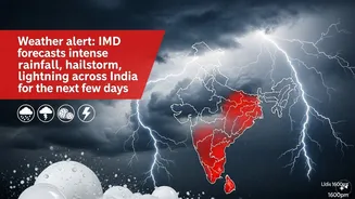


Thunderstorm Alert Issued
The India Meteorological Department (IMD) has issued a significant warning regarding escalating thunderstorm activity across West Bengal, particularly
on April 9. This heightened activity is attributed to a confluence of favorable atmospheric conditions, including a specific wind pattern and substantial moisture influx from the Bay of Bengal. These meteorological factors are conducive to widespread thunderstorms across several districts of the state during the April 8-9 period. The Regional Meteorological Centre in Kolkata has further elaborated that an east-west trough stretching from northwest Uttar Pradesh to Manipur, coupled with an upper air cyclonic circulation situated over Chhattisgarh, are the primary drivers behind the anticipated widespread thunderstorms. This meteorological setup creates an environment ripe for significant weather disturbances.
Regional Rainfall Predictions
In South Bengal, areas like Kolkata, East Midnapore, and the districts of North and South 24 Parganas, along with Howrah and Nadia, are expected to experience light to moderate rain on April 9. The IMD's forecast indicates that thunderstorms, accompanied by lightning and wind speeds reaching 30-40 kmph, are likely to occur in these specific regions. For the remaining districts of South Bengal, similar weather phenomena are predicted to occur at a few places. Meanwhile, North Bengal is also under the weather watch, with districts such as Darjeeling, Jalpaiguri, Kalimpong, Cooch Behar, and Alipurduar anticipated to receive fairly widespread rain and thundershowers on the same day. Isolated thunderstorms with lightning and winds up to 50 kmph are also a possibility in these northern areas. This indicates a broad swathe of the state will be affected by significant weather events.
Extended Forecast and Temperature Trends
The rainfall is not expected to dissipate immediately after April 9. In North Bengal, light to moderate rainfall is forecast to persist in regions like Darjeeling and Alipurduar from April 10 through April 14. Conversely, the weather scenario in South Bengal is projected to improve from April 10 onwards. Rainfall is expected to become more isolated, with dry weather conditions anticipated to dominate across most of the southern districts between April 11 and April 12. In terms of temperature, daytime temperatures are predicted to remain largely stable on April 9. However, following this, a gradual increase of 4–6°C is expected across the entire state over the subsequent four days, suggesting a transition towards warmer conditions after the initial spell of rain and thunderstorms.
Safety Advisories and Precautions
The IMD has issued crucial safety advisories due to the potential hazards associated with these thunderstorms. Residents are alerted to the risks of lightning strikes, which can be dangerous. There's also a possibility of damage to temporary structures, uprooting of trees, and disruptions to power and communication lines. Furthermore, standing crops may suffer damage, and reduced visibility during heavy rain could pose challenges for traffic in urban centers. The public is strongly advised to remain indoors during thunderstorm activity, avoid seeking shelter under trees or near electric poles, and to stay away from water bodies. In a separate warning for maritime activities, fishermen are cautioned against venturing into the sea along and off the West Bengal and north Odisha coasts for the next 24 hours due to the forecast of squally winds reaching up to 60 kmph.