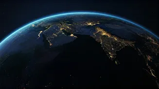








A Shifting Nightscape
Recent analysis from NASA's Black Marble initiative, spanning nearly a decade of satellite observations, reveals a surprisingly nuanced picture of Earth's
artificial illumination. Contrary to a uniform brightening, the data indicates a complex interplay of factors leading to significant regional variations. While the planet's overall nighttime radiance saw a notable increase of 34% between 2014 and 2022, this surge is accompanied by areas experiencing a distinct dimming. This bidirectional transformation highlights how human activities, from technological advancements to geopolitical events, are creating a dynamic and often contrasting evolution of our planet's illuminated footprint after sunset. The project meticulously isolates human-generated light, offering a clear view of these intricate changes.
Regional Contrasts Unveiled
Examining specific regions illustrates the multifaceted nature of these nighttime light shifts. In the United States, for instance, increased urbanization and population growth led to brighter cityscapes on the West Coast, while many East Coast areas dimmed due to the adoption of energy-efficient LED lighting and economic restructuring. Europe, driven by conservation policies and a commitment to reducing light pollution, also displayed a decline in nighttime brightness, with France leading in dark-sky initiatives. Conversely, emerging economies in sub-Saharan Africa and Southeast Asia have experienced substantial brightening due to expanding electrification and infrastructure projects. Asia, particularly China and northern India, showed some of the most significant increases in illumination, reflecting rapid development. Conversely, areas embroiled in conflict or experiencing economic instability, such as Ukraine, Lebanon, Yemen, Afghanistan, and Venezuela, showed sharp dimming, a direct consequence of war, damaged infrastructure, or economic collapse.
Black Marble's Illuminating Technology
NASA's Black Marble product is a sophisticated tool designed to provide an unadulterated view of human-generated light. It employs advanced techniques to filter out interference from natural phenomena like moonlight, cloud cover, snow, and atmospheric distortions. The Visible Infrared Imaging Radiometer Suite (VIIRS) instrument, aboard satellites like Suomi-NPP, NOAA-20, and NOAA-21, captures light across a broad spectrum, from green to near-infrared. This capability allows scientists to precisely monitor a variety of artificial light sources, including urban sprawl, industrial operations, and even the lights of fishing fleets at sea. This technology has evolved into one of the most detailed, long-term archives of Earth's nighttime luminosity, moving beyond earlier, less dynamic composite maps.
Beyond Pretty Pictures
The value of the Black Marble data extends far beyond the creation of visually striking maps. Nighttime light measurements serve as a crucial resource for researchers across diverse fields. Scientists utilize this data to track the pace of urban expansion, assess the progress of disaster recovery efforts, monitor widespread power outages, gauge industrial output, and even understand migration patterns. Furthermore, the information provides critical insights into the growing concern of light pollution, which poses significant challenges for astronomers observing the night sky, impacts ecological systems and animal behavior, and is increasingly recognized for its potential effects on human health, particularly circadian rhythms. The ability to observe these changes over time offers a unique perspective on global development and its environmental consequences.