






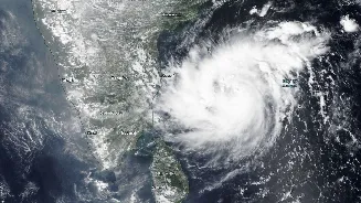

The Bay of Bengal is churning once again as Severe Cyclonic Storm Akvan gathers strength, putting coastal regions on high alert. This is the third major system in recent weeks, following the impacts of Cyclones Murasu and Arnab.
The Latest Threat: What We Know About Akvan
Severe Cyclonic Storm Akvan
is currently moving over the west-central Bay of Bengal and is expected to make landfall around noon on November 20. According to the India Meteorological Department (IMD), the storm is predicted to cross the coast between Narsapur in Andhra Pradesh and Puri in Odisha. As of the latest updates on November 19, the storm was located several hundred kilometres off the coast of Andhra Pradesh and Odisha, moving northwards. Authorities have issued a red message for the coasts of North Andhra Pradesh, Yanam, and South Odisha. Forecasts predict maximum sustained wind speeds of 90-100 kmph, with gusts reaching up to 110 kmph at landfall. In preparation, officials in Odisha have already begun evacuating tens of thousands of people from vulnerable low-lying areas. Heavy to extremely heavy rainfall is expected along coastal Andhra Pradesh and Odisha, with warnings also in effect for parts of West Bengal. Fishermen have been advised to stay out of the sea until the system passes.
A Season of Storms: Murasu and Arnab
Akvan arrives on the heels of an active post-monsoon cyclone season. In early November, Severe Cyclonic Storm Murasu made landfall in Andhra Pradesh between Bapatla and Prakasam districts on November 2. Murasu caused significant damage to crops and property and resulted in several fatalities. Just a week before that, Very Severe Cyclonic Storm Arnab battered the same coastline, making landfall on October 28 between Kakinada and Konaseema districts. Arnab was the first named storm of the 2026 season and rapidly intensified before hitting the coast, causing widespread damage to infrastructure and agriculture and forcing the evacuation of over 180,000 people in Andhra Pradesh and Odisha. The back-to-back impacts of Arnab and Murasu have left coastal communities particularly vulnerable as they now brace for Akvan.
The Story Behind the Names
Ever wonder where these storm names come from? They aren't chosen at random. Cyclones in the North Indian Ocean, which includes the Bay of Bengal and the Arabian Sea, are named by the Regional Specialised Meteorological Centre (RSMC) in New Delhi, operated by the IMD. The names are pulled from a list submitted by 13 member countries of a World Meteorological Organization panel. These countries are Bangladesh, India, Iran, Maldives, Myanmar, Oman, Pakistan, Qatar, Saudi Arabia, Sri Lanka, Thailand, the UAE, and Yemen. The names are used sequentially from the list. 'Arnab' was a name contributed by Bangladesh, meaning 'ocean'. 'Murasu', a Tamil word for a traditional drum, was a name given by India. The current storm, 'Akvan', was suggested by Iran. A storm is only given a name when it intensifies to a Cyclonic Storm, with wind speeds of at least 62 km/h.
Why the Bay of Bengal Is a Cyclone Hotspot
The Bay of Bengal's geography and climate make it particularly prone to cyclonic storms. Its semi-enclosed, funnel-like shape can amplify storm surges, while the sea surface temperatures are consistently warm, often above the 28°C threshold needed to fuel these powerful systems. The Bay also receives a significant inflow of fresh, warm water from major rivers like the Ganga and Brahmaputra. This freshwater forms a layer on top of the saltier sea water, which heats up more easily and provides abundant moisture and energy for cyclones to form and intensify. Furthermore, conditions like weak vertical wind shear (the difference in wind speed and direction at different altitudes) allow storms to develop a stable, organised structure. These factors, especially during the post-monsoon season (October to December), create a perfect breeding ground for cyclones.