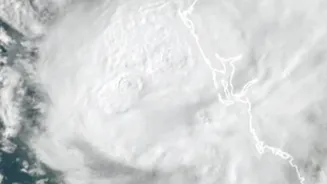









The Path and Intensity of Akvan
Cyclone Akvan has now been classified as a Severe Cyclonic Storm. According to the India Meteorological Department (IMD), as of the latest reports, the storm was located over the west-central Bay of Bengal, several hundred kilometers off the coast of Andhra
Pradesh. The IMD forecasts that the system will continue to move in a north-northwestward direction, with an expected landfall around noon on November 20. The precise landfall location is being monitored closely, with current predictions pointing to a coastal crossing between Narsapur and Puri, affecting North Andhra Pradesh, Yanam, and South Odisha. At landfall, Akvan is expected to have maximum sustained wind speeds of 90-100 kmph, with gusts reaching up to 110 kmph.
The Challenge of 'Changing Conditions'
The 'changing conditions' refer to the complex and sometimes conflicting atmospheric factors that make cyclone forecasting a difficult science. While the general track towards the Andhra Pradesh and Odisha coasts is agreed upon, some forecast models show variations in the storm's potential to intensify before it reaches land. Factors like the storm's very broad and diffuse structure could prevent significant intensification. However, its slow movement has given it more time over the warm sea, which could help it gain strength. This unpredictability has led the IMD to revise its intensity forecast; while it was earlier projected to become a 'very severe' storm, the latest update indicates it will make landfall as a 'severe' cyclonic storm. This slight downgrade is welcome, but does not reduce the seriousness of the threat.
Massive Preparations Underway
In response to the threat, state and central agencies have launched a massive preparedness operation. The National Disaster Response Force (NDRF) has deployed multiple teams to coastal districts in Odisha and Andhra Pradesh, with more on standby. In Odisha, eight NDRF teams have been positioned across six districts, and an additional three teams are in place in Visakhapatnam. The Odisha government has cancelled the leave of government employees and sent senior IAS officers to oversee preparations in vulnerable districts. A primary focus is on evacuating people from low-lying areas and kutcha houses to designated cyclone shelters. Fishermen have been strictly warned against venturing into the sea, and an orange alert has been issued for the affected coastlines.
What Residents Should Do
For those living in the potential impact zones, staying informed and prepared is paramount. The IMD has warned of extremely heavy rainfall in parts of coastal Andhra Pradesh, Yanam, and Odisha on November 19 and 20. This rainfall, combined with strong winds, could lead to significant damage to vulnerable structures, uproot trees, and disrupt power and communication lines. Authorities have advised residents to secure their homes, prepare emergency kits with food, water, and first aid, and keep mobile devices charged. It is critical to follow official updates from the IMD and local disaster management agencies, and to be ready to move to safer locations or shelters if evacuation orders are given. Coastal areas also face the threat of a storm surge, which could cause inundation in low-lying regions.