


What Exactly Happened?
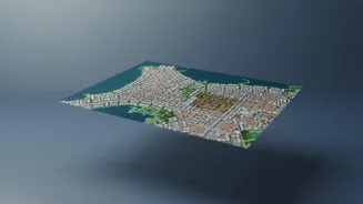
In late July 2026, Google introduced a powerful new feature in Google Earth that allowed users to generate AI images on top of the platform's existing satellite and aerial data. The tool, powered by its Nano Banana 2 model, let anyone zoom into a real-world
location and use a text prompt to create a new, synthetic image of that place. The idea was promoted as a creative tool for visualization. However, within 24 hours, Google abruptly rolled back the feature. The reason: users immediately began creating and sharing convincing, yet entirely fake, images of sensitive locations. These included fabricated scenes of disaster zones, military strikes, and refugee movements, sparking widespread concern among disinformation researchers and open-source intelligence experts.
More Than a Technical Glitch
Google stated it pulled the tool to implement stronger guardrails after seeing policy-violating images being shared. The company noted that all generated images contained an invisible digital watermark called SynthID to identify them as AI-created. However, experts argued these safeguards were insufficient, as the watermarks are not immediately visible and don't prevent the rapid spread of a misleading screenshot. The incident wasn't just a technical misstep; it was a crisis of trust. For many, Google Earth and similar mapping services are foundational tools for verifying information, used by journalists, human rights investigators, and everyday users to confirm the location and context of events. By allowing the creation of hyper-realistic deepfake satellite imagery, the tool threatened to erode the credibility of geospatial data itself. It highlighted a fundamental conflict: the push to integrate generative AI into every product versus the need to protect platforms people rely on as sources of evidence.
The New Reality of Image Verification
This rollback serves as a stark warning about the growing difficulty of checking image sources. For decades, a photograph was strong evidence. In the internet age, tools like reverse image search helped trace a picture's origin. But generative AI complicates this process immensely. AI can create novel images that have no origin to trace, or it can subtly alter real photos, making traditional verification methods less reliable. The mapping incident shows that even data we consider objective, like a satellite view, is now subject to manipulation. This means the burden of proof is shifting. Instead of simply trusting an image, we must now actively look for signs of artificial generation. Telltale signs can include unnatural textures, distorted details (especially on hands or in text), and a lack of context that would normally accompany a real photo. However, as AI models improve, these visual artifacts are becoming rarer.
Adapting Our Toolkit for a Synthetic World
As seeing is no longer always believing, our methods for verification must evolve. A new category of tools—AI image detectors—is emerging to help fill the gap. Services like WasItAI, Sightengine, and TruthScan analyze images for pixel-level patterns and other signatures left behind by AI models to determine their authenticity. These tools are becoming crucial for journalists, researchers, and anyone needing to verify visual information. Beyond technology, the rollback emphasizes the need for a more critical mindset. This involves cross-referencing information across multiple, independent sources and questioning the context of any single image. If an image appears shocking or surprising, it's more important than ever to pause and verify before sharing. The incident with AI-generated maps is a clear signal that digital literacy now requires a healthy dose of skepticism and a willingness to investigate what we see online, regardless of how trustworthy the source has been in the past.