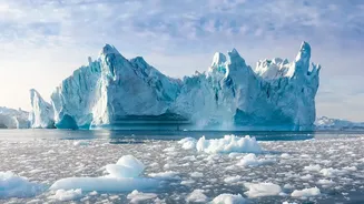








Visualising an Unthinkable Number
It can be difficult to comprehend the scale of 11.3 trillion tonnes of ice. It is enough frozen water to bury the entire continental United States five feet deep. Another way to picture it is to imagine the water spread across all of Sweden, where it would
form a layer 25 metres thick. This colossal loss of mass, tracked by an international team of scientists using data from 27 different satellite missions, has already had a measurable impact on our planet: it has raised the global average sea level by 3.14 centimetres. While that might not sound like much, every centimetre of sea-level rise puts millions more people at risk of coastal flooding and erosion.
How Is the Ice Being Lost?
This comprehensive scientific assessment, known as the Ice Sheet Mass Balance Inter-comparison Exercise (IMBIE), revealed a crucial detail: the ice is not just melting from the top down. In fact, only about 16% of the ice loss was due to warmer air causing surface melting. A stunning 84% was driven by what scientists call 'ice dynamics'. This is where warming ocean waters are melting the ice sheets from below, causing glaciers to speed up and discharge massive quantities of ice directly into the sea much faster than they can be replenished by snowfall. This dynamic response to a warming ocean is the primary driver of the long-term trend.
An Accelerating Trend
The rate of loss hasn't been steady; it has dramatically accelerated. The study shows that ice loss climbed sharply starting in the 1990s. In the 1980s, Antarctica was losing about 48 billion tonnes of ice per year; by the 2010s, that figure had soared to 202 billion tonnes annually. Greenland saw a similar jump, going from around 60 billion tonnes per year in the 1980s to 264 billion in the 2010s. While there was a temporary slowdown between 2020 and 2023 due to unusually high snowfall in East Antarctica and milder summers in Greenland, scientists caution this does not reverse the long-term trend. Together, the two ice sheets are now responsible for about a quarter of all global sea-level rise.
Why It Matters for India
A few centimetres of sea-level rise in a global average translates to a significant threat for a country with a 7,500-kilometre coastline and numerous low-lying cities. India is particularly vulnerable because the Indian Ocean is warming rapidly. Major metropolitan areas like Mumbai, Kolkata, and Chennai are already facing increased risks of frequent and severe flooding. This isn't a distant problem; it's happening now. Recurrent floods in Mumbai disrupt transport and the economy, while saltwater intrusion threatens freshwater supplies in Chennai. The threat is compounded in areas where the land itself is sinking, a process known as subsidence. Beyond the cities, coastal erosion is a major concern, with studies indicating that about a third of India's coastline is vulnerable.
The Human and Economic Cost
The consequences of rising seas are not just environmental but deeply human and economic. The UN warns that millions of people in low-lying South Asian deltas, including in and around Mumbai and Kolkata, are at immediate risk of displacement. A city doesn't have to be permanently underwater to suffer severe impacts. More frequent and intense flooding can damage critical infrastructure, disrupt supply chains, and impact key economic sectors like fishing and tourism. Saltwater seeping into farmland can ruin crops and threaten food security. The new data on ice loss provides a stark reminder that what happens in the planet's coldest regions has direct and costly consequences for communities thousands of kilometres away.