





A Deluge Out of Nowhere
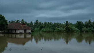
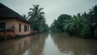
In early August, parts of central Kerala were shattered by a catastrophic deluge. After a period of deficit monsoon, a sudden, violent burst of rain triggered deadly landslides and flash floods, particularly in the hilly districts of Idukki, Kottayam,
and Pathanamthitta. The event saw rivers like the Pamba and Manimala swell in hours, inundating towns and cutting off communities. With at least 28 confirmed fatalities and thousands displaced into relief camps, the speed of the disaster caught residents and authorities off guard, leaving a trail of destruction that is tragically becoming an annual horror.
The Gap Between Alert and Reality
The India Meteorological Department (IMD) did issue alerts. On August 4, a red alert was in place for eight districts, indicating a forecast of extremely heavy rainfall. However, the reality check came from the nature of the rainfall. The warnings, while geographically broad, struggled to capture the ferocity of the highly localised, cloudburst-like events that occurred. These short, intense downpours unleashed more water than the ground could absorb, leading to rapid runoff and landslides. For the people on the ground, a general red alert did not translate into a specific warning of an imminent, life-threatening landslip in their immediate vicinity, highlighting a critical gap between a weather forecast and an actionable, impact-based warning.
The Science of Surprise Storms
Forecasting these events is a massive scientific challenge. Meteorologists point to the rise of what are called "mesoscale convective systems" – intense, rapidly developing storm cells that are extremely difficult to predict with precision. Standard numerical weather models are better at forecasting large-scale weather patterns over wider areas and longer durations. They often struggle to pinpoint the exact location and timing of a 'mini cloudburst' that can dump over 100mm of rain in a single hour over a few square kilometres. The hilly terrain of Kerala's Western Ghats further complicates this, as it can amplify rainfall in unpredictable ways.
A System Under Unprecedented Strain
While forecasting technology faces limitations, experts argue that the problem is also systemic. The recurring nature of these floods reveals a collision between a changing climate and decades of unsustainable development. The natural sponges of the landscape—forests, wetlands, and paddy fields that once absorbed excess rainwater—have shrunk dramatically due to quarrying, construction, and land-use changes. This means that when extreme rain does fall, the water has nowhere to go, rushing down slopes and into floodplains with greater speed and destructive power. Even with perfect forecasts, the state's very topography has been altered in ways that make it more vulnerable.
From Forecast to Actionable Intelligence
The path forward requires a paradigm shift from just predicting weather to managing risk. Experts and even citizen-led initiatives are calling for more hyper-local monitoring and decentralised warning systems. This involves investing in a denser network of Doppler radars and automatic rain gauges to improve 'nowcasting' – short-term, high-resolution forecasts. It also means strengthening the 'last mile' of communication, ensuring that even if a forecast is broad, local authorities are empowered and equipped to translate it into specific evacuation orders based on local vulnerabilities. The recent tragedy underscores that technology alone is not enough; it must be integrated with robust local governance and community preparedness.