



What Are Atmospheric Rivers?
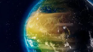
Atmospheric rivers are long, narrow bands of concentrated water vapor that transport moisture from the tropics toward the poles. These 'rivers in the sky' can stretch for thousands of kilometers and carry more water than some of the world's largest land-based
rivers. They are a vital part of the global water cycle, responsible for delivering essential rain and snow that replenishes water supplies. On the U.S. West Coast, for example, they can provide up to half of the region's annual precipitation. However, the most powerful of these events can also be destructive, stalling over an area and releasing torrential rain that leads to devastating floods, mudslides, and widespread damage.
How Climate Change Is Rerouting the Flow
The core of the issue lies in basic physics: a warmer atmosphere can hold more moisture. For every degree Celsius of warming, the air's capacity to hold water vapor increases by about seven percent. This means that as global temperatures rise due to greenhouse gas emissions, atmospheric rivers are being supercharged. Studies project they will become longer, wider, and carry significantly more moisture. But it's not just about intensity; their paths are also changing. Research shows a distinct poleward shift in both the Northern and Southern Hemispheres, meaning these moisture-laden storms are tracking toward higher latitudes. This redrawing of the map means regions historically reliant on this precipitation may see less, while areas unaccustomed to such deluges may face them more frequently.
The Consequences: A World of Extremes
The alteration of these atmospheric water routes is intensifying weather extremes globally. More potent atmospheric rivers directly translate to a higher risk of catastrophic flooding. At the same time, the geographic shift in their storm tracks can have the opposite effect elsewhere. Regions that once depended on predictable seasonal rainfall from these systems may find themselves facing prolonged dry spells and an increased risk of drought. This creates a volatile new reality of water management, where some communities must brace for unprecedented floods while others grapple with water scarcity. In short, the planet's water cycle isn't just changing, it's becoming more polarized and less predictable.
Uneven Impacts Across Regions
These changes won't be felt uniformly. Research highlights that different regions will experience the effects in unique ways. For instance, while atmospheric rivers are projected to intensify along the entire U.S. Pacific Coast, the driving mechanisms and specific outcomes will vary. Northern areas may see greater flood risk from storm-driven ocean water rise, while Southern California's impacts may be altered by different atmospheric processes. Globally, climate models project a dramatic increase in the frequency of these events under high-emission scenarios, with some models suggesting the number of atmospheric rivers could increase by over 100% in the summer months by the end of the century. The North Indian Ocean and Greenland are expected to see particularly sharp increases, threatening to disrupt ecosystems and overwhelm infrastructure not built for such heavy precipitation.
What Scientists Are Watching Next
Scientists are working to refine their understanding of these complex systems. While the overall trend of intensification due to warming is clear, researchers are also exploring how natural cycles, like El Niño and La Niña, interact with these human-caused changes. Some studies have noted that while greenhouse gases create a warming effect that boosts atmospheric rivers, industrial aerosols have had a cooling effect that partially counteracted this, though this balance is expected to shift as emissions change. Improving forecasting models is a top priority, as better predictions can give communities anywhere from five to seven days of advance warning to prepare for a major event, allowing water managers and emergency officials to take crucial, life-saving action. A new global map of these water highways is helping to trace their typical journeys, offering a powerful tool for anticipating where and when these extreme events may strike.