



The View from the Ground
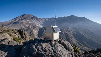
For decades, the foundation of volcano monitoring has been a network of instruments placed directly on or near the volcano itself. These are the frontline sensors, providing a continuous, real-time pulse of the mountain's health. Seismometers are crucial,
acting like a stethoscope to listen for the tell-tale rumbles and swarms of small earthquakes caused by magma moving beneath the surface. Then there are tools to measure ground deformation—the subtle swelling or sinking of the volcano's flanks as its internal magma chamber fills or empties. Instruments like tiltmeters measure tiny changes in the slope's angle, while high-precision Global Positioning System (GPS) stations can track vertical and horizontal ground movement down to the centimetre. Finally, gas sensors analyse the air for changes in the chemical cocktail of gases like sulphur dioxide and carbon dioxide, which can signal that magma is rising. These ground-based tools are incredibly sensitive and provide a constant stream of data, but they have their limits. They can be expensive and dangerous to install and maintain on active, remote, or unstable volcanoes. They also only provide information about the specific points where they are installed, potentially missing the bigger picture.
The Eye in the Sky
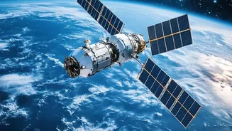
This is where satellite technology revolutionises the field. Orbiting hundreds of kilometres above the Earth, satellites offer a safe and comprehensive way to watch over volcanoes, including those in the most remote corners of the globe. One of the most powerful satellite techniques is Interferometric Synthetic Aperture Radar, or InSAR. By comparing two radar images of the same volcano taken at different times, scientists can create a detailed map of ground deformation across the entire mountain, not just at a few GPS points. This technique can work day or night and through clouds, which is a major advantage during a volcanic crisis. Satellites also carry instruments that can detect invisible signals of unrest. Thermal infrared cameras can spot an increase in ground temperature, a potential sign of magma nearing the surface. Spectrometers can measure the amount of volcanic gases like sulphur dioxide in the atmosphere from space, tracking plumes that could be hazardous to aircraft and communities downwind. While satellites provide incredible breadth, their main drawback can be timing, as they only pass over a specific volcano periodically.
A Powerful Partnership
Neither method is perfect on its own, which is why combining them is standard practice for modern volcanology. They work in synergy, with each method's strengths compensating for the other's weaknesses. For instance, a satellite using InSAR might detect a broad area of swelling on a remote volcano that shows no other signs of life. This 'tip-off' from space can prompt scientists to deploy ground-based instruments like seismometers and gas sensors to get a more detailed, high-frequency look at what's happening. The satellite provides the wide-angle view, while the ground sensors provide the close-up, moment-by-moment details. Ground-based GPS provides highly precise, continuous 3D deformation data at one point, which perfectly complements the broader, but less frequent, spatial map provided by InSAR. This integrated approach allows scientists to build a much more complete and reliable model of what is happening inside a volcano.
From Data to Warning
This combination of eyes in the sky and ears on the ground has proven effective around the world. At Mount St. Helens in the United States, the initial signs of reawakening after its 1980 eruption were carefully tracked with both ground and satellite data. At volcanoes in Italy, Ecuador, and Indonesia, the combination of satellite thermal data, gas measurements, and ground-based seismic monitoring gives authorities a more robust basis for issuing warnings and managing risks. When a satellite detects a thermal anomaly and ground sensors simultaneously record a swarm of earthquakes, the confidence in a forecast increases dramatically. It's this process of cross-verification between different data streams that allows scientists to move from observation to life-saving alerts. This comprehensive monitoring doesn't just help predict an initial eruption; it's also vital for tracking ongoing activity, like the direction of ash plumes that pose a serious threat to aviation.