






The Unforgettable Cost of Delay
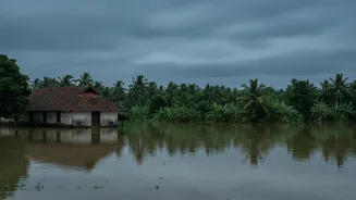
The 2018 monsoon brought Kerala to its knees. Over 400 people lost their lives, and lakhs were displaced as relentless rains triggered catastrophic floods and landslides. Analysis after the deluge pointed to systemic failures, including a lack of specific
early warnings and uncoordinated releases from brimming dams that amplified the disaster. While official rescue systems were overwhelmed, an incredible grassroots response emerged. Kerala’s fishermen, with their intimate knowledge of local waters, voluntarily navigated treacherous currents in their own boats, rescuing an estimated 65,000 stranded people. Their heroism highlighted a crucial truth: when top-down systems falter, local knowledge and community action become the last line of defence. The event served as a painful catalyst, forcing a complete re-evaluation of the state’s approach to disaster management.
The Current State of Warnings
Traditionally, India’s disaster alerts have followed a top-down model. The India Meteorological Department (IMD) and Central Water Commission (CWC) provide forecasts and data, which state-level bodies like the Kerala State Disaster Management Authority (KSDMA) then disseminate to districts and the public. In recent years, technology has advanced this system significantly. The national SACHET portal sends geo-targeted emergency SMS alerts. More recently, India has been testing a more robust, indigenous Cell Broadcast Alert System (CBAS). This technology can send pop-up alerts to all mobile phones connected to specific cell towers, bypassing congested SMS networks and not requiring an internet connection. While this allows for more precise geographic targeting than a blanket state-wide alert, the information flow remains largely centralized, originating from government authorities.
Going Granular: The Hyper-Local Idea
A hyper-local alert system is more than just a geographically targeted message; it represents a fundamental shift in how disaster risk is understood and communicated. Instead of relying solely on broad regional forecasts, it uses a dense network of on-ground sensors to capture real-time, block-level data. Imagine automatic weather stations in every few square kilometres, soil moisture sensors on vulnerable slopes, and river gauges providing continuous data streams. This torrent of information is then fed into AI models that can predict, with far greater accuracy, which specific hamlet is at risk of a flash flood or which hillside is showing signs of an impending landslide. The promise is a warning that is not just timely but also highly specific and actionable, empowering a family to evacuate rather than causing panic across an entire district.
More Than Just an App
Kerala is already moving in this direction. As of 2026, the state has begun rolling out a network of AI-powered automatic weather stations, developed with IIT Ropar, to provide hyper-local forecasts to local bodies and farmers. Furthermore, advanced landslide warning systems that use deep-earth sensors and AI analysis are being deployed in high-risk zones to provide four-stage alerts directly to the KSDMA. The state government has also announced plans for a comprehensive AI-backed disaster management programme to strengthen forecasting. However, the path is not without obstacles. These systems require significant investment in infrastructure, constant maintenance, and a reliable power and communication backbone that can withstand the very disasters they are meant to predict. The real challenge lies in transforming this complex data into simple, trustworthy alerts that people will act on.
People, Not Just Pings
Ultimately, technology alone is not a silver bullet. The KSDMA itself has acknowledged that for any warning system to be effective, it must be “people-centered.” This means moving beyond just broadcasting alerts and actively involving communities in their own safety. Kerala has started pioneering this approach by piloting community-owned disaster management plans in some of its most remote and vulnerable tribal hamlets. These projects integrate the traditional knowledge of indigenous populations with modern scientific mapping, empowering local residents to become key players in risk assessment, planning, and response. This bottom-up approach builds resilience from the ground up, ensuring that when an alert—hyper-local or otherwise—is issued, there is a trained and prepared community ready to act.