



A Confusing Rumble from the Mountains
Seismometers are incredibly sensitive instruments designed to listen for the shudder of the Earth's tectonic plates. But in the geologically volatile Himalayas, they pick up more than just earthquakes. Massive debris flows, landslides, and glacial lake
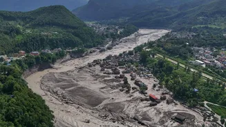
outburst floods—where dams of ice and rock suddenly fail—also generate powerful ground vibrations. A recent catastrophic flood along the Nepal-China border highlighted this challenge when initial reports from agencies like the US Geological Survey flagged a magnitude 4.4 earthquake. Officials and the public were led to believe the disaster was tectonic. However, as devastation swept through downstream valleys, investigators found a different culprit: the signal was not from the earth shifting, but from a colossal glacial collapse. The sheer force of ice and rock crashing down the mountain had mimicked a quake, generating its own seismic event powerful enough to be reclassified as a magnitude 5.2. This initial misreading underscores a high-stakes problem: when every second counts, the wrong diagnosis can lead to the wrong emergency response.
Cracking the Seismic Code
The key to avoiding this confusion lies in the unique signature each event leaves on a seismogram. Investigators have learned to distinguish the seismic grammar of a quake from that of a flood. A tectonic earthquake typically begins with a sharp, high-frequency jolt from what are known as P-waves, which travel quickly through the planet. This is followed by slower, more rolling surface waves. In contrast, the seismic signal from a debris flow or flood is different. It often lacks that initial sharp jolt and is characterized by sustained, longer-period waves. Scientists refer to this as the event's "seismic footprint." By analyzing these patterns, they can do more than just identify the source; they can reconstruct the event itself. Advanced algorithms can now turn the raw seismic data into a rich picture of the flood, estimating its velocity, the volume of water, and the amount of debris it carries. Some methods can even detect the subtle tilting of the ground as the immense weight of the floodwaters pass over, allowing its path to be tracked in real time.
From Signal to Life-Saving Warning
This ability to translate a seismic rumble into a detailed flood profile is a game-changer for early warning systems. Traditional flood monitoring often relies on river gauges, but these are vulnerable and often among the first casualties in a major event, getting washed away or losing power just when they are needed most. Seismic monitoring offers a more resilient alternative. Because seismometers can be located kilometers away from the flood path, they can continue operating and provide crucial data from a safe distance. Research analyzing past events, such as a devastating 1994 glacial lake outburst in Bhutan, showed that seismic stations had unknowingly recorded the flood's signal a full five hours before it reached a downstream village. With today's understanding, that signal could be immediately identified and used to issue a specific, actionable flood warning, giving communities precious hours to evacuate. This transforms a network of earthquake sensors into a dual-use system for disaster preparedness.
A Himalayan Climate Imperative
Nowhere is this technology more critical than in the Himalayas. As climate change accelerates, the region's thousands of glaciers are retreating, feeding rapidly growing glacial lakes. Many of these lakes are dammed by unstable moraines of rock and ice, posing a constant threat of outburst floods, known as GLOFs. The 2015 Gorkha earthquake further destabilized many slopes, increasing landslide risk. These cascading hazards—where a warming climate leads to unstable glaciers, and heavy rains or seismic activity trigger collapses—are becoming more frequent. The ability to use seismic data to detect and characterize these events is therefore not merely a scientific curiosity; it is an essential tool for adaptation in one of the world's most vulnerable regions. It also highlights the need for greater cross-border cooperation on early warning systems between Himalayan nations like Nepal, India, and China, which all share the same river systems and risks.