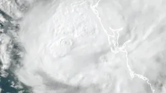









What We Know About Akvan's Path
The India Meteorological Department (IMD) is closely tracking Severe Cyclonic Storm Akvan, which has been moving north-northwestwards over the Bay of Bengal. According to the latest bulletins, the storm is expected to make landfall around noon on November
20. The projected path will see it cross the coast between Narsapur in Andhra Pradesh and Puri in Odisha. As of late on November 18, the system was located approximately 480 km southeast of Narsapur. Upon landfall, it is expected to be a severe cyclonic storm with maximum sustained wind speeds of 90-100 kmph, gusting up to 110 kmph.
Coastal States on High Alert
In response to the IMD's warnings, state governments in Andhra Pradesh and Odisha have activated their disaster management protocols. The IMD has issued a 'Red Message' for the coasts of North Andhra Pradesh, Yanam, and South Odisha. Fishermen have been warned to stay out of the sea for the next several days. In Odisha, the government has announced the closure of schools in six districts and deployed 74 rescue teams from the ODRAF and NDRF. Authorities in Andhra Pradesh have also placed coastal districts on high alert, with preparations underway for potential evacuations from low-lying and vulnerable areas. A storm surge of 1-2 metres above the astronomical tide is likely to inundate low-lying coastal areas of Andhra Pradesh.
The Science of Cyclone Naming
The name 'Akvan' was suggested by Iran and is part of a list of names for tropical cyclones in the North Indian Ocean. This naming system is managed by the World Meteorological Organization/Economic and Social Commission for Asia and the Pacific (WMO/ESCAP) Panel on Tropical Cyclones. The process involves 13 member countries, including India, who each contribute a list of names. These names are then used sequentially. Assigning names to cyclones helps in their identification, creates public awareness, and assists disaster managers and the media in disseminating warnings effectively without confusion, especially if multiple storms are active at the same time.
A Frequent Threat in the Bay
The Bay of Bengal is a known hotspot for tropical cyclones, particularly during the post-monsoon season in October and November. Cyclone Akvan is the third major system to threaten the Andhra Pradesh coast in just the last month, following Cyclones Arnab and Murasu, which made landfall in late October and early November respectively. This frequency underscores the region's vulnerability and the critical importance of India's increasingly sophisticated early warning systems. The IMD now employs a multi-stage alert system, starting with a Pre-Cyclone Watch 72 hours in advance and progressing to Cyclone Alerts (yellow) and Warnings (orange) as a storm nears. These systems, along with initiatives like the National Cyclone Risk Mitigation Project, have been instrumental in improving preparedness and reducing casualties.
How to Stay Safe
Residents in the affected coastal districts are advised to follow official instructions from local authorities and the IMD. It is crucial to stay updated through official channels and avoid spreading rumours. If you are in an area under alert, prepare an emergency kit with essentials like non-perishable food, water, batteries, a first-aid kit, and important documents. Secure your home by boarding up windows and removing loose objects from outside that could become projectiles in high winds. Be aware of your nearest designated cyclone shelter and be prepared to evacuate if instructed to do so by authorities. During the storm, stay indoors and away from windows. After it passes, be cautious of fallen power lines, weakened structures, and contaminated floodwaters.