







Meet ISRO's Newest Sentinel: EOS-05
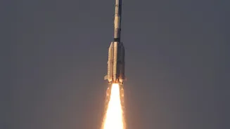
On September 4, 2026, the Indian Space Research Organisation (ISRO) successfully launched its latest Earth observation satellite, EOS-05, aboard the GSLV-F17 rocket. Placed into a Sub-Geosynchronous Transfer Orbit, the satellite is now making its way
to its final orbital slot. This isn't just another satellite joining India's large constellation; EOS-05 is a state-of-the-art spacecraft designed to perform a mission unlike any of its predecessors, fundamentally changing how India can monitor its geographical region. It represents a significant technological leap, establishing a new capability for the nation's space program.
The Geosynchronous Game-Changer
The most significant aspect of EOS-05 is its destination: a geosynchronous orbit approximately 36,000 kilometres above the Earth. Most Earth-imaging satellites, like those in the Cartosat or RISAT series, operate in a Low Earth Orbit (LEO), just a few hundred kilometres up. While LEO satellites can capture incredibly detailed images, they are constantly moving, meaning they only pass over a specific location for a few minutes at a time. In contrast, a satellite in geosynchronous orbit moves in sync with the Earth's rotation. This allows EOS-05 to remain stationed over the same broad region, providing persistent, near-continuous watch over the Indian subcontinent and the surrounding oceans. This trades the extreme close-up detail of LEO for the invaluable advantage of constant presence.
All-Weather Vision with Synthetic Aperture Radar
EOS-05’s imaging power comes from its advanced payload, reported to be a sophisticated Synthetic Aperture Radar (SAR). Unlike optical cameras that depend on sunlight and clear skies, SAR is an active sensor. It sends out its own microwave signals and reads the echoes that bounce back, effectively creating a detailed image of the surface below. This gives it the remarkable ability to see through clouds, haze, rain, and complete darkness. For a country like India, which experiences long monsoon seasons, this all-weather, day-and-night capability is transformative. It ensures that monitoring capabilities are never compromised by weather conditions or the time of day, a critical requirement for disaster management and security surveillance.
A New Era for Monitoring and Security
The unique combination of a fixed viewpoint and all-weather imaging opens up a host of new applications. For disaster management, EOS-05 can provide uninterrupted tracking of developing cyclones, monitor floodwaters in real-time during heavy monsoons, and assess damage from other natural calamities. In terms of national security, the satellite offers an unprecedented strategic advantage, enabling continuous surveillance of land borders and vast maritime territories for monitoring movements and protecting national interests. Beyond security, its data will support a wide range of civilian applications, from monitoring agricultural health and water resources to tracking deforestation and the impact of climate change.
India's Evolving Space Strategy
The deployment of EOS-05 is a key part of India's evolving space strategy. It doesn't replace the high-resolution LEO satellites but rather complements them, creating a multi-layered observation system. While LEO satellites provide detailed tactical imagery, EOS-05 provides the broad, strategic overview. This mission also aligns with the national goal of developing cutting-edge, autonomous space capabilities. As ISRO continues to focus on advanced research and development, the data from such sophisticated platforms is also becoming a key part of India's growing space economy. The commercial arm, NewSpace India Limited (NSIL), is tasked with marketing ISRO's products and services, and the unique data from EOS-05 could create new commercial opportunities in sectors like insurance, agriculture, and infrastructure monitoring.