



The Fire-Breathing Dragon
When a wildfire grows to an immense size and intensity, it can generate what is known as a pyrocumulonimbus cloud (PyroCb), or more simply, a fire-generated thunderstorm. NASA has dubbed it the 'fire-breathing dragon of clouds' for good reason. Unlike
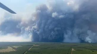
a normal thunderstorm that forms from atmospheric moisture and heat, a PyroCb is born directly from the violent energy of a massive blaze on the ground. Recently, a wildfire in France’s Gironde region became so intense that it produced one of these towering storm clouds, an event that officials stated had never been recorded in the country before. These are not just passive smoke plumes; they are active, self-sustaining weather systems that can dramatically alter the course of a fire.
How a Fire Becomes a Storm
The process begins with extreme heat. A huge wildfire acts like a massive engine, sucking in air and sending a superheated column of air, ash, and smoke shooting upwards at great speed. As this column, or plume, rises into the upper atmosphere, it encounters much lower air pressure, causing it to expand and cool rapidly. The moisture carried within the plume—both from the air and from the burning vegetation—condenses onto the tiny ash particles. This forms a 'pyrocumulus' or fire cloud. If the fire is powerful enough, this updraft can push the cloud to heights of 10 kilometres or more, where temperatures are well below freezing. At these altitudes, it evolves into a full-blown pyrocumulonimbus, complete with the internal mechanics of a thunderstorm.
A Vicious and Unpredictable Cycle
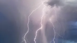
The danger of a fire-generated thunderstorm lies in the vicious feedback loop it creates. Once formed, the cloud is no longer just a symptom of the fire; it becomes a driver of it. Inside the churning cloud, collisions between ice particles and supercooled water droplets generate immense static electricity, resulting in lightning. This lightning can strike miles away from the initial blaze, igniting new fires in fresh, unburnt landscapes. Furthermore, the storm generates its own powerful and erratic winds. Strong downdrafts can slam into the ground and push the fire in unpredictable directions at terrifying speeds, making containment efforts for firefighters exceptionally dangerous and nearly impossible. In some cases, these systems can even produce hail and fire-whirls, similar to tornadoes.
A Frightening Sign of the Times
While pyrocumulonimbus clouds have been documented before, particularly during intense fire seasons in Australia and North America, their appearance in places like Europe is a concerning development. Experts see the increasing frequency and intensity of wildfires as a direct consequence of a warming climate, which creates hotter and drier conditions that act as fuel. These conditions make fires more likely to reach the 'megafire' status required to generate their own weather. The fire-weather feedback loop—where fires release enormous amounts of carbon, further warming the climate and leading to more severe fire conditions—is a critical challenge. The rare event in France serves as a stark reminder that as the planet warms, the behaviour of wildfires is becoming more extreme and unpredictable, posing new threats to ecosystems and communities worldwide.