





A Volcano Beneath The Fens?
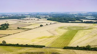
It’s a startling idea, but geologists have confirmed the presence of a vast, ancient volcanic system buried deep beneath the surface of Eastern England. What is now a famously flat landscape, covering parts of Norfolk and Lincolnshire, was once the site
of immense geological turmoil. There are no mountains or craters visible today; the entire structure is hidden, a secret kept by hundreds of metres of younger rock and sediment deposited over countless millennia. Its discovery wasn't made by climbers, but by scientists analysing data from boreholes and magnetic surveys, piecing together a puzzle from deep within the Earth's crust.
A World 450 Million Years Ago
To visit this volcano, you would need a time machine set for the Late Ordovician period, around 454 million years ago. The world was unrecognisable. The land that would become England was part of a microcontinent called Avalonia, located much further south, closer to the equator. It was separated from the landmass that would become Scandinavia by an ancient body of water called the Tornquist Sea. This region was part of an active volcanic zone, similar to the modern-day Pacific 'Ring of Fire'. While the Eastern England volcano was erupting, other volcanic systems were also active, creating the rocks that would eventually form the rugged landscapes of Wales and England's Lake District.
An Eruption of Epic Proportions
The eruption, or series of eruptions, from this volcano were extraordinarily powerful. Scientists classify it as a 'super-Plinian' event, an extremely explosive eruption that blasts ash and gas high into the stratosphere. The evidence for this cataclysm comes from a thin layer of volcanic ash, known as the Kinnekulle tephra, found spread across vast areas of Norway, Sweden, and Poland. For decades, the origin of this ash layer was a geological mystery. But recent analysis has solved it. By studying tiny, resilient zircon crystals found in borehole samples from Norfolk and Lincolnshire, scientists were able to get a precise date for the eruption. The age of the crystals, 454.4 million years, was a near-perfect match for the age of the ash in Scandinavia, proving the ash had travelled across the ancient sea.
How Science Uncovered the Secret
The first clues to this hidden world came from surveys in the 20th century that detected gravitational and magnetic anomalies—subtle changes that suggested unusual rock formations deep underground. Exploratory drilling for other resources provided rock samples, some of which were collected as far back as 80 years ago. It was the application of modern, high-precision dating techniques on these old samples that finally connected the dots. By analysing the decay of uranium into lead within the zircon crystals, researchers could create a geological clock, pinpointing the eruption's date with incredible accuracy and linking it directly to the mysterious ash layer in Europe. This geological detective work solved a decades-old puzzle and completely reshaped the understanding of England's deep past.
From Fiery Mountain to Flat Farmland
So, what happened to this giant volcano? The answer lies in the immense timescale of geology. After its violent period of activity, the volcano went extinct. Over millions of years, the processes of erosion wore it down. The continent of Avalonia drifted north and collided with others, and the landmass that was once a high volcanic peak began to sink. Through subsequent geological periods, including the Jurassic when dinosaurs roamed, the entire area was submerged beneath shallow seas. Layer upon layer of sediment—sands, clays, and chalk—settled on the seabed, burying the volcano's remains ever deeper. Much later, Ice Age glaciers sculpted the final, flat landscape we see today, leaving no surface trace of the fire that once raged below.